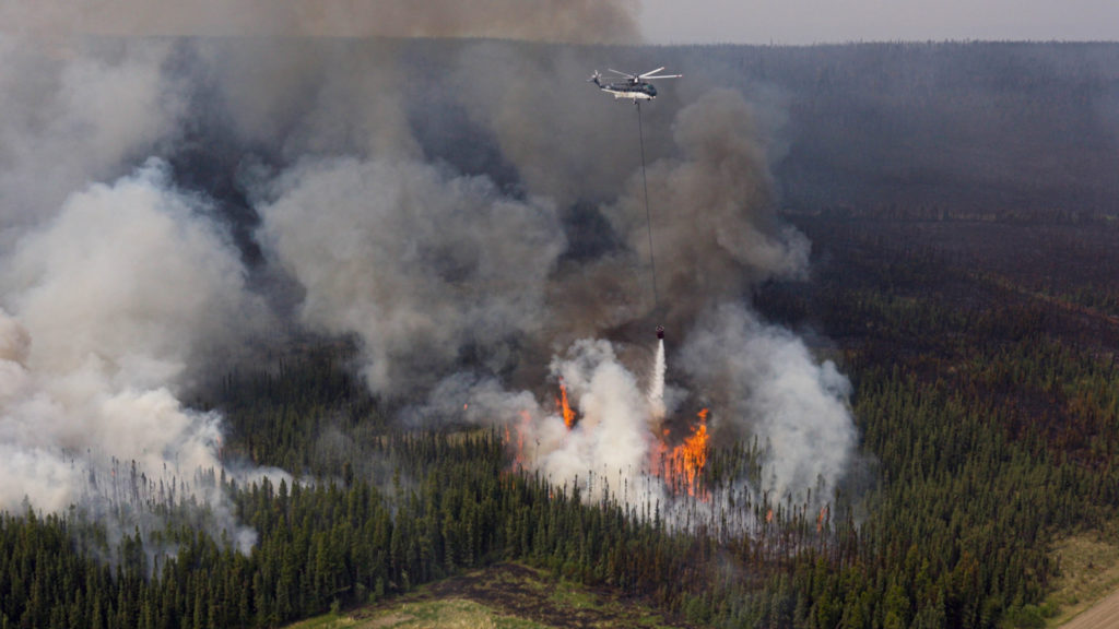
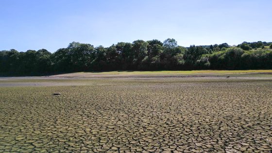
Wildfire seasons in Western Canada are intensifying, with 2023 seeing more than 2,240 fires burning 2.84 million hectares in B.C. and insured losses of $720 million in the Okanagan/Shuswap and $1.3 billion from the 2024 Jasper fire, forcing repeated evacuations at sites such as Artemis Gold’s Blackwater and Cameco’s Cigar Lake. Operators and insurers are now treating wildfire as a core business-interruption risk, driving investment in backup generation for long transmission corridors, detailed continuity planning, and stricter underwriting. Engineers are also redesigning mine layouts and buildings for fire, favouring sites on ridge tops, wider building separation, non-combustible steel roofing and use of natural and linear infrastructure firebreaks.
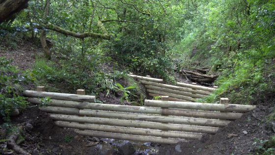
National Trust and United Utilities are installing a series of timber “leaky dams” on moorland and farmland above the Stubbins Estate in Lancashire in a two‑year natural flood management programme to slow runoff into the River Irwell. The structures are designed to back up high flows in small headwater channels while allowing baseflow to pass, temporarily storing stormwater on the floodplain and in upstream depressions. For civil and drainage engineers, the scheme signals continued deployment of low‑cost, nature‑based attenuation measures alongside conventional hard‑engineered defences in upland catchments.
Construction recorded the highest number of worker fatalities in Britain in 2025/26, according to new Health and Safety Executive (HSE) figures on work-related deaths. Although absolute numbers are not yet broken down publicly by sub-sector, the data place construction ahead of manufacturing, agriculture and waste, continuing a long-term pattern of disproportionate risk. The figures will sharpen scrutiny of temporary works design, work-at-height controls and plant–people interface management on sites, particularly for SMEs and subcontractor-heavy projects.
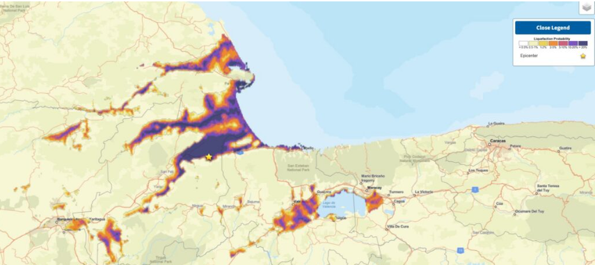
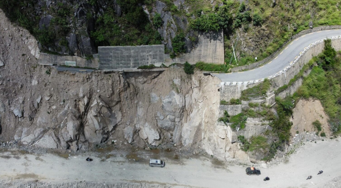
Recent major earthquakes in Venezuela and the southern Philippines have exposed how delayed mapping of landslides and liquefaction can mask the worst damage for days, especially in remote mountain valleys and low-lying coastal plains. Geoscientists are pushing for rapid post-event zonation using satellite interferometry, UAV photogrammetry and pre-existing susceptibility maps to identify blocked river valleys, buried roads and lateral spreading along reclaimed or alluvial ground. For geotechnical teams, this means integrating near-real-time remote sensing with ground reconnaissance to prioritise slope stabilisation, bridge access and lifeline corridor repairs.
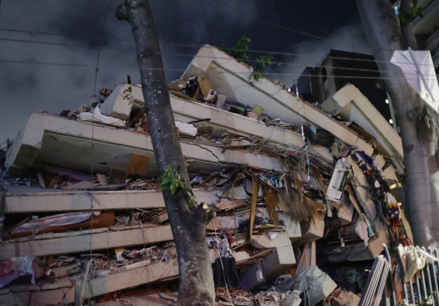
Two shallow earthquakes of magnitude 7.1 and 6.8 struck near Caracas and La Guaira within hours, collapsing mid‑rise reinforced concrete apartment blocks and older unreinforced masonry in hillside barrios, with hundreds confirmed dead and thousands displaced. Liquefaction, lateral spreading and rockfalls have damaged key transport links, including sections of the Caracas–La Guaira motorway and port access roads, complicating access for rescue equipment and temporary shoring. Geotechnical teams are racing to assess slope stability on steep, weathered tropical soils and to prioritise demolition versus retrofit of heavily cracked shear‑wall structures.
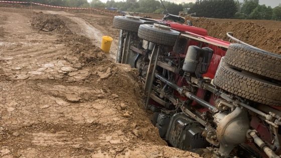
A joint venture contractor on HS2 has been fined £400,000 after a 20 t tipper truck left the edge of an excavation ramp, leaving the driver with multiple serious injuries. The incident involved a temporary earthworks access ramp where the truck overran the unprotected edge and rolled into the excavation. The case signals renewed scrutiny of haul road and ramp design, edge protection, and traffic management on major UK infrastructure sites, particularly for heavy earthmoving plant.
Calls are growing for the UK Government to consult coastal erosion communities more regularly when updating Shoreline Management Plans (SMPs), which guide long-term decisions on hold-the-line, managed realignment and no-active-intervention policies. Local authorities and residents argue that current SMP review cycles and engagement processes do not adequately reflect rapid cliff retreat, increased storm surge impacts and changing sediment transport patterns on vulnerable frontages. More frequent, structured consultation could influence choices on hard defences versus nature-based solutions, funding priorities and property loss compensation frameworks.
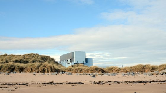
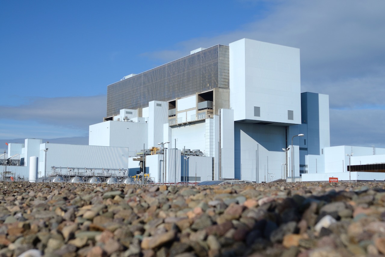
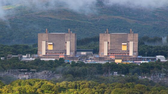
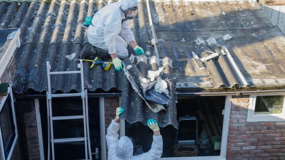
EDF and Trillium Flow Services UK have each received two improvement notices from the Office for Nuclear Regulation over asbestos-related shortfalls at the Torness nuclear power station in East Lothian, Scotland. ONR inspectors identified deficiencies in how asbestos-containing materials were identified and controlled during maintenance activities, prompting formal enforcement action. Contractors and asset owners working on ageing nuclear infrastructure should expect closer scrutiny of asbestos registers, method statements and supervision where legacy insulation and gaskets remain in service.
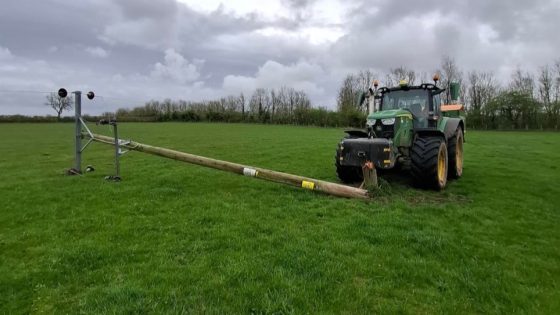
Farm machinery and agricultural vehicles have struck overhead powerlines and other electrical assets 22 times in the past 12 months in the North West of England, prompting a formal safety warning from the regional network operator. Incidents typically involve high-reach kit such as telehandlers, slurry tankers and combine harvesters contacting 11kV and 33kV lines on field margins and farm access tracks. Civil and farm infrastructure designers are being urged to review clearance envelopes, access road alignments and signage to reduce strike risk during peak harvesting and slurry-spreading operations.
Improvement notices have been served by the Office for Nuclear Regulation to EDF and Trillium Flow Services UK Ltd after potential asbestos exposure during a March 2026 valve overhaul on the steam system at Torness Nuclear Power Station, East Lothian. ONR found asbestos had been identified and removed from a similar valve in 2024 but not entered into the site asbestos register, which is meant to be the central record for location and condition of asbestos and was reportedly not consistently consulted in maintenance planning. EDF has suspended all in-house asbestos removal while it addresses failures under the Health and Safety at Work etc Act 1974 and Control of Asbestos Regulations 2012, with Trillium also cited for inadequate work-log close-out and pre-maintenance asbestos assessment.
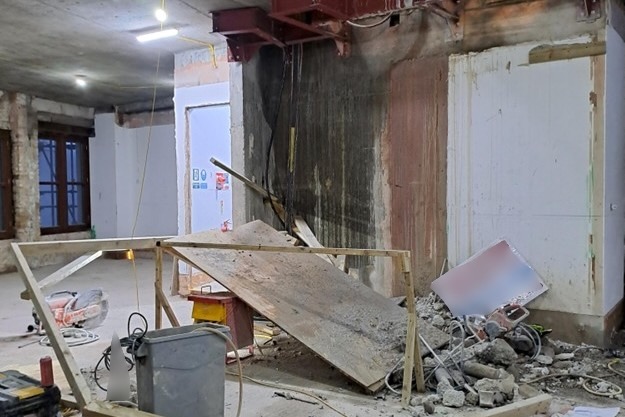
Temporary platform collapse on a Roots Contractors Limited site left drilling operative Steve Zschoch with a fractured neck after he was “folded up like a concertina” beneath the failed structure while working for subcontractor Diacutt Limited. Both firms have now been fined for safety failings relating to the design, installation and verification of the temporary working platform, which was being used for drilling operations. The case reinforces the need for formal temporary works design checks, competent supervision and load-path verification for access platforms on small civil and infrastructure projects.
Sinkholes discovered by Network Rail engineers on a rail bridge outside Purley have forced the closure of all lines between Purley and East Croydon, severing direct rail links between central London and Gatwick Airport. The defect was identified during planned engineering works, prompting immediate suspension of services on this key section of the Brighton Main Line. Geotechnical teams now face urgent investigation of foundation conditions and void extent beneath the bridge, with stabilisation and monitoring requirements likely to dictate the duration of disruption.
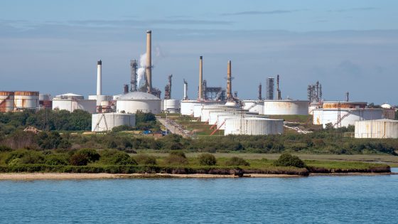
Esso has been fined £1M by the UK Health and Safety Executive after 2.4t of highly flammable liquefied petroleum gas leaked from ageing plant at ExxonMobil’s Fawley Refinery due to failures in managing equipment integrity. The incident, which exposed workers to “life-threatening risks”, stemmed from inadequate inspection and maintenance of pipework and associated fittings in a hazardous area of the site. Process safety engineers and asset managers are likely to face closer scrutiny of inspection regimes, corrosion monitoring, and lifecycle replacement strategies for high-pressure LPG systems.
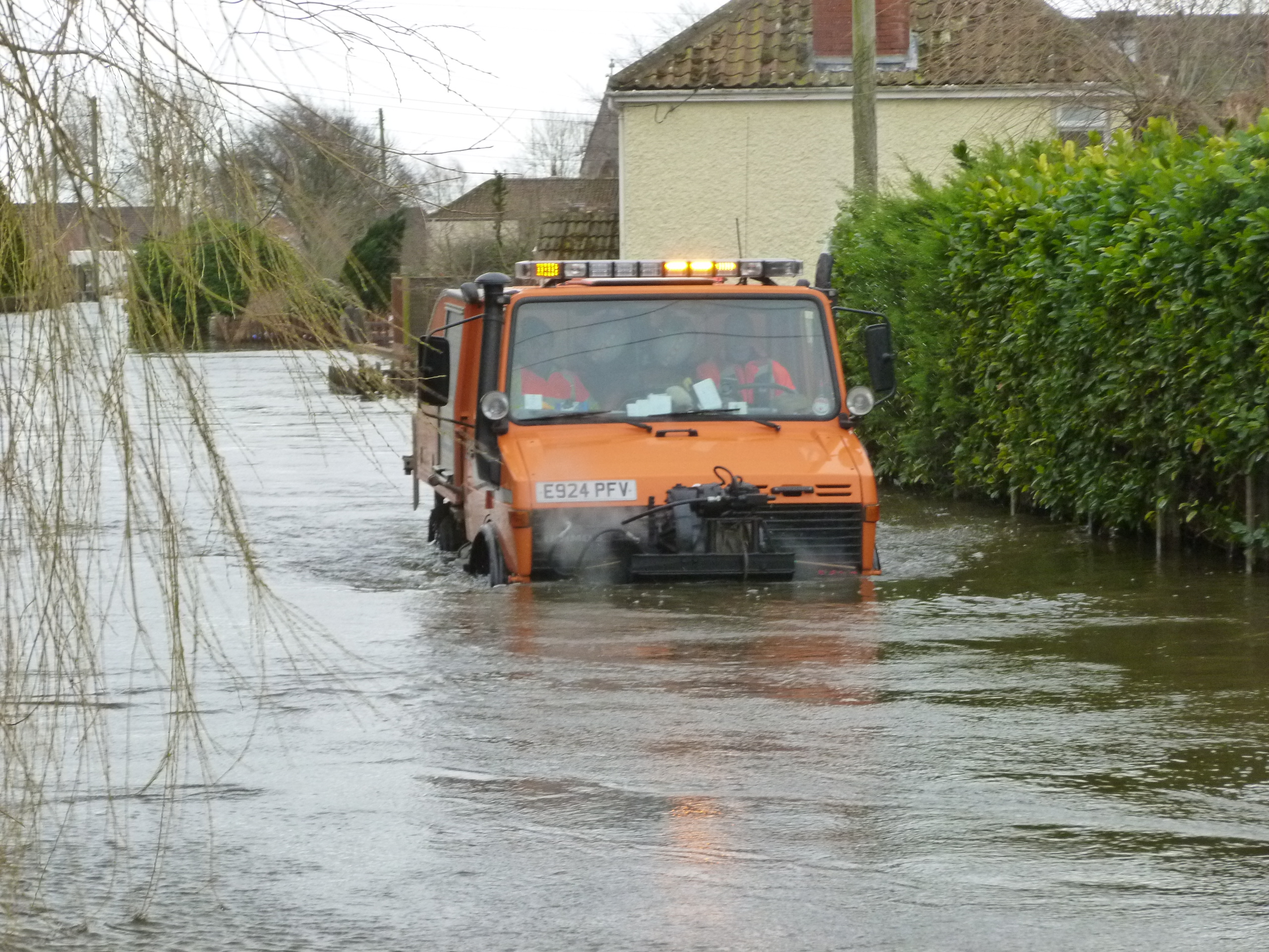
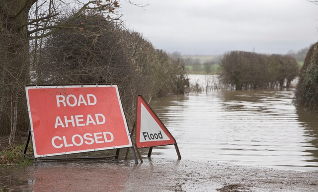
£50M of government funding has been pledged to upgrade flood resilience in Somerset after “severe” winter flooding earlier this year. The package is expected to support works such as raising and strengthening existing earth embankments on the Somerset Levels, improving pump stations and sluices on key drainage rhynes, and expanding temporary and permanent flood storage. For civil and geotechnical teams, the focus will be on embankment stability in saturated ground, long-term seepage control, and designing assets for more frequent high-intensity rainfall.
A magnitude 7.8 earthquake struck offshore Mindanao, Philippines, at a depth of about 32 km, killing at least 19 people and injuring more than 130 across Surigao del Sur, Davao Oriental and neighbouring provinces. Strong shaking triggered widespread liquefaction, lateral spreading and coastal slope failures, damaging bridges, port facilities and low-rise reinforced concrete buildings with soft-storey behaviour. Engineers are prioritising rapid assessment of pile-supported structures on reclaimed land, stability of coastal embankments and the integrity of lifeline corridors linking key mining and agricultural areas.
South West Water has been fined £1.85M at Exeter Magistrates’ Court after a Cryptosporidium contamination at the Hillhead treatment works left tens of thousands of Devon customers without potable tap water in summer 2026. The DWI prosecution centred on failures in disinfection and monitoring barriers required under the Water Supply (Water Quality) Regulations, including inadequate protozoa control and delayed public notification. Other water companies are now ramping up enforcement and risk reviews of treatment works, with particular focus on UV systems, filtration integrity and contingency planning for microbial outbreaks.
Completion of the highest activity radioactive waste management programme at the Trawsfynydd nuclear power station in north Wales marks a key decommissioning milestone after roughly 20 years of work. High‑risk materials from the Magnox-era site have now been retrieved, conditioned and placed into shielded intermediate-level waste stores designed for long-term containment and future transfer to a geological disposal facility. The shift away from active waste handling allows decommissioning teams to focus on structural dismantling, civil works on reactor buildings and progressive reduction of radiological hazards on site.
CIRIA has issued a Good practice guide for managing climate change and extreme weather in land development, the first UK guidance to directly link projected climate impacts with physical changes in geotechnical and geoenvironmental conditions across the full project life cycle. Trigger events cited include the 2022 heatwave, which generated 23,000 subsidence claims and an estimated £219m payout by ABI members, and Storm Babet’s 2023 bridge collapses. The two-part guide combines current climate–geo risk knowledge with a practical framework, diagrams, tools, and case studies to structure consistent assessment of shrink–swell, flooding, groundwater shifts, and landslides.
Escalating extreme rainfall and glacial melt are driving more frequent floods and landslides in Nepal’s Himalayan districts, with Karnali Province’s steep, highly fractured slopes and narrow river valleys particularly exposed. Recent events include debris flows cutting off road access to remote settlements and riverbank erosion undermining gabion walls and informal river training works along the Karnali and Bheri rivers. Engineers are being pushed towards slope stabilisation with bioengineering, improved drainage, and relocation or elevation of critical infrastructure away from active channels and unstable colluvium.
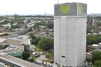
Metropolitan Police say they remain on schedule to submit full Grenfell Tower fire charging files to the Crown Prosecution Service by the end of September, nearly 10 years after the 2017 disaster. The investigation has reviewed the roles of 15,000 individuals and 700 organisations, with 57 people and 20 organisations now suspected of offences including gross negligence manslaughter, misconduct in public office, fraud and health and safety breaches. Evidence gathered includes 165 million electronic files, 14,400 witness statements and over 27,000 physical exhibits such as cladding, insulation, doors and windows.
The Climate Change Committee warns that the “British way of life” faces escalating risk from heat, flooding and drought, with the Institution of Civil Engineers backing calls for rapid, large‑scale adaptation of UK infrastructure. Priority actions flagged include upgrading urban drainage and flood defences for more intense cloudbursts, retrofitting buildings for sustained 40°C heat, and securing water supply resilience against multi‑year droughts. For civil and geotechnical engineers, this signals imminent pressure to redesign assets for higher hydraulic loads, thermal stresses and soil moisture variability within the next planning cycle.
Annual UK asbestos-related deaths of around 5,000, cited by removal specialist Rhodar, are being used to warn that ageing building stock still contains extensive legacy asbestos in insulation boards, sprayed coatings and pipe lagging. The warning targets civil and infrastructure works on schools, hospitals and 1960s–80s public buildings, where intrusive refurbishments, drilling and core sampling risk disturbing poorly documented asbestos-containing materials. Engineers are being urged to tighten pre-construction surveys, update asbestos registers and enforce licensed removal and enclosure protocols on all invasive works.
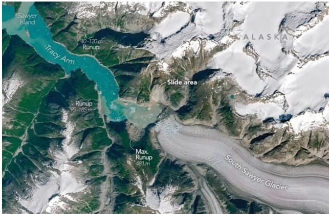
A 10 August 2025 rockslide in Alaska’s Tracy Arm Fjord sent more than 64 million m³ of rock and debris into the water, generating a megatsunami with an estimated maximum run-up of about 481 m along the steep fjord walls, the second-highest recorded after Lituya Bay 1958. The failure was linked to support loss from South Sawyer Glacier’s retreat, with the narrow fjord geometry strongly amplifying wave heights. No casualties occurred, but the near miss for cruise traffic signals a rising landslide–tsunami hazard in deglaciating fjords that must be factored into navigation and infrastructure risk assessments.
Willow Services (Southern) Ltd has been fined £20,000 plus £5,607 costs at Westminster Magistrates’ Court after roofer Mark Smith fell approximately 11 feet through an unguarded loft hatch while re-roofing a house in Waterlooville on 13 May 2024, suffering fractures to his L1 vertebra and hip. HSE investigators found the company had not planned the work at height, failed to install basic fall prevention around the loft opening, and provided no competent supervision. The case signals continued strict enforcement of Regulation 4(1) of the Work at Height Regulations 2005 on small contractors.
Geomechanics, Streamlined.
© 2026 Geomechanics.io. All rights reserved.