Colombia rainfall 64% above average: slope failure lessons for engineers
Reviewed by Joe Ashwell

First reported on Geoengineer.org – News
30 Second Briefing
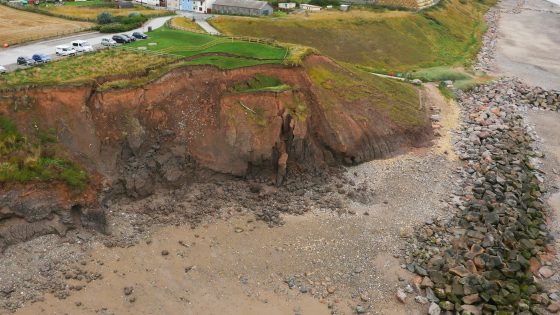
Rainfall 64% above the February average has triggered widespread flooding and landslides across Colombia, killing at least 13 people and affecting more than 10,000, with Antioquia, Cundinamarca and Valle del Cauca among the hardest-hit departments. Rivers including the Magdalena and Cauca have overtopped banks, damaging road embankments, bridge approaches and hillside settlements, and forcing evacuations in multiple municipalities. Geotechnical teams face saturated slopes, debris flows and scour at culvert and retaining-wall foundations, with authorities warning of further failures if intense rainfall persists.
Technical Brief
- Failure mechanisms include shallow translational slides in weathered volcanic soils and debris flows in steep gullies.
- Overtopping and prolonged ponding are driving embankment softening, loss of shear strength and local slope regressions.
- Investigation focus is on mapping active scars, profiling saturated soil horizons and checking culvert/bridge foundations for scour.
- Authorities are deploying drone reconnaissance and rapid LiDAR-based inventories to prioritise unstable slopes near settlements and roads.
- Monitoring measures include temporary piezometers, visual crack mapping and patrols of river training works during peak stages.
- Remediation planning centres on emergency drainage, debris clearance, toe buttressing and selective relocation of exposed households.
- Events reinforce the need for rainfall-threshold early warning systems and slope hazard zoning in Andean transport corridors.
Our Take
Colombia appears only sporadically in our 42 Hazards stories, so a 64% rainfall anomaly with 13 fatalities signals conditions that operators should treat as an outlier stress test for slope stability and drainage design rather than a routine wet season event.
For projects tagged under Failure and Safety in Colombia, such intense rainfall implies that design storms and return periods used in tailings, waste dumps and access-road drainage may now be under-specified, pushing engineers towards more conservative hydrological and geotechnical criteria.
Given the lack of specific project or company names here, this kind of nationwide flooding is likely to affect both formal mines and informal hillside workings, which in our database are often the most exposed to rainfall-triggered landslides due to minimal ground support and ad hoc water management.
Prepared by collating external sources, AI-assisted tools, and Geomechanics.io’s proprietary mining database, then reviewed for technical accuracy & edited by our geotechnical team.
Related Articles

Related Industries & Products
Mining
Geotechnical software solutions for mining operations including CMRR analysis, hydrogeological testing, and data management.
Construction
Quality control software for construction companies with material testing, batch tracking, and compliance management.
CMRR-io
Streamline coal mine roof stability assessments with our cloud-based CMRR software featuring automated calculations, multi-scenario analysis, and collaborative workflows.