Morocco flooding from extreme rainfall and dam releases: stability lessons for engineers
Reviewed by Tom Sullivan

First reported on Geoengineer.org – News
30 Second Briefing
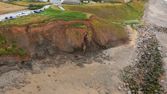
More than 140,000 people have been evacuated from low-lying towns and rural communities in northwestern Morocco after extreme rainfall and emergency releases from multiple upstream dams caused major flooding along several river valleys. Rapid drawdown and high downstream discharges are stressing ageing embankment protections, inundating agricultural terraces and damaging road and bridge approaches, with several river crossings reportedly overtopped. Geotechnical teams now face urgent inspections of dam abutments, spillway structures and saturated slopes, alongside rapid debris clearance to reopen key access routes for relief and repair works.
Technical Brief
- Rapid drawdown is likely inducing transient pore pressure gradients within dam shells and abutment contacts.
- Monitoring priorities include continuous piezometer readings, settlement markers on embankments and crack mapping on spillway training walls.
- Remediation options will centre on riprap replacement, local grouting of seepage zones and temporary berms at eroded toes.
- For similar basins with cascade dams, coordinated operating rules and updated PMP/PMF studies become critical design inputs.
Our Take
Within the 42 Hazards stories in our database, Morocco and northwestern Africa appear far less frequently than high-profile flood regions like South Asia, so this event is likely to prompt re‑rating of hydrological design assumptions for dams and urban drainage in the country.
For projects tagged with Failure and Safety in our coverage, post‑event investigations often lead to revised spillway operating rules and updated probable maximum flood estimates; Moroccan dam operators can expect similar regulatory scrutiny around reservoir management and emergency release protocols after this flooding.
The scale of evacuations in northwestern Morocco will be a reference case for future project ESIAs in the region, with lenders and insurers likely to demand more detailed flood‑risk modelling and community evacuation planning even for inland infrastructure schemes.
Prepared by collating external sources, AI-assisted tools, and Geomechanics.io’s proprietary mining database, then reviewed for technical accuracy & edited by our geotechnical team.
Related Articles

Related Industries & Products
Construction
Quality control software for construction companies with material testing, batch tracking, and compliance management.
Mining
Geotechnical software solutions for mining operations including CMRR analysis, hydrogeological testing, and data management.
CMRR-io
Streamline coal mine roof stability assessments with our cloud-based CMRR software featuring automated calculations, multi-scenario analysis, and collaborative workflows.
HYDROGEO-io
Comprehensive hydrogeological testing platform for managing, analysing, and reporting on packer tests, lugeon values, and hydraulic conductivity assessments.
GEODB-io
Centralised geotechnical data management solution for storing, accessing, and analysing all your site investigation and material testing data.