Green River Desimone levee failure: stability lessons for flood engineers
Reviewed by Tom Sullivan

First reported on Geoengineer.org – News
30 Second Briefing
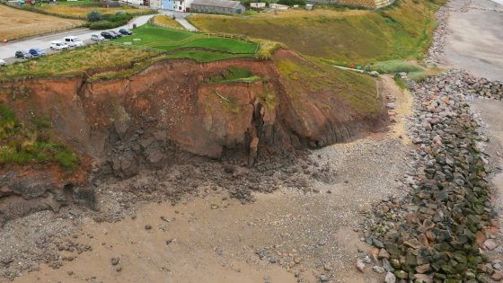
A levee breach on the Desimone levee along Washington’s Green River near Tukwila occurred under atmospheric river rainfall, with river levels peaking near 22 feet after a rapid 15‑foot rise in one week, exceeding six decades of recorded stages. The failure, a vehicle‑sized opening caused by internal erosion under prolonged high hydraulic loading, triggered flash flood warnings and evacuations for more than 45,000 residents in low‑lying areas. Emergency works using large sandbags and temporary fill stabilised the embankment, but saturated foundation soils and elevated groundwater leave wider regional levee and slope stability at risk from further storms.
Technical Brief
- Internal erosion risk was known pre-failure, with emergency seepage control measures already installed in the Desimone levee.
- Breach geometry was highly localised, described as roughly the size of a passenger vehicle opening.
- Emergency stabilisation used large sandbags and temporary fill placed by heavy equipment to buttress the eroded section.
- Response actions were coordinated under flash-flood warning protocols, triggering formal evacuation notices in low-lying Green River communities.
- Regional geotechnical risk increased by prior atmospheric river flooding, leaving foundation soils saturated and pore pressures elevated before this event.
- Ongoing monitoring should prioritise piezometric levels, seepage emergence and slope deformation along adjacent levee reaches and valley slopes.
- For ageing US levee systems, the case reinforces the need for continuous condition assessment and adaptive seepage-control upgrades under more frequent extreme storms.
Our Take
Among the 17 Hazards stories in our database, this Green River failure is one of the few that couples rapid river stage rise (15 ft in a week) with legacy levee systems, signalling that older urban flood defences in places like Tukwila, Kent and Renton are likely to be critical weak points during atmospheric river sequences.
The 10‑year Sacramento River levee improvement horizon in the United States, contrasted with the relatively short 1 km new levee at Ormenio in Greece, suggests North American operators facing Green River–type events may need to prioritise staged upgrades and interim risk‑reduction measures rather than waiting for full corridor rebuilds.
With fatalities highlighted in Shenzhen and Tahiti failures in the same Hazards category, the non‑fatal but disruptive Green River incident underscores that geotechnical teams in the Pacific Northwest should treat ground stability around levees as a safety issue on par with major slope and foundation collapses, not just a flood‑control problem.
Prepared by collating external sources, AI-assisted tools, and Geomechanics.io’s proprietary mining database, then reviewed for technical accuracy & edited by our geotechnical team.
Related Articles

Related Industries & Products
Mining
Geotechnical software solutions for mining operations including CMRR analysis, hydrogeological testing, and data management.
Construction
Quality control software for construction companies with material testing, batch tracking, and compliance management.
CMRR-io
Streamline coal mine roof stability assessments with our cloud-based CMRR software featuring automated calculations, multi-scenario analysis, and collaborative workflows.
HYDROGEO-io
Comprehensive hydrogeological testing platform for managing, analysing, and reporting on packer tests, lugeon values, and hydraulic conductivity assessments.
GEODB-io
Centralised geotechnical data management solution for storing, accessing, and analysing all your site investigation and material testing data.