Over 2,500 poor-condition US dams: satellite risk insights for dam engineers
Reviewed by Tom Sullivan

First reported on Geoengineer.org – News
30 Second Briefing
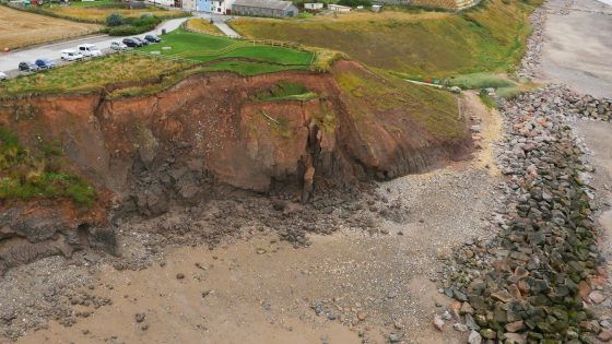
Satellite analysis of more than 16,700 US dams shows over 2,500 structures are both in poor condition and classified as high-hazard potential, meaning failure would likely cause loss of life. Geoscientists report many of these ageing embankment and concrete gravity dams lack adequate spillway capacity, suffer from seepage and erosion issues, and sit downstream of growing urban development. The findings point to large unfunded backlogs in dam safety upgrades, with implications for risk-based inspection, emergency drawdown planning and prioritisation of remedial works.
Technical Brief
- Work is limited to surface deformation; internal erosion, piping and spillway structural defects remain undetected by InSAR alone.
Our Take
Within the 19 Hazards stories in our coverage, the United States features more often for tailings and flood-control issues than for conventional mine-slope failures, so a large population of structurally poor dams signals a growing interface risk for downstream mining and industrial facilities.
For U.S.-based Projects tagged under Safety and Research, operators are increasingly being pushed by insurers and regulators to integrate remote-sensing data into dam safety cases, meaning satellite-derived condition assessments are likely to become a de facto baseline rather than an optional add-on.
A finding that thousands of U.S. dams are in poor condition implies that many smaller, legacy structures may fall outside current capital planning cycles, which in practice can delay remediation on industrial and mine-related water-retention dams until after a near-miss or regulatory intervention.
Prepared by collating external sources, AI-assisted tools, and Geomechanics.io’s proprietary mining database, then reviewed for technical accuracy & edited by our geotechnical team.
Related Articles

Related Industries & Products
Mining
Geotechnical software solutions for mining operations including CMRR analysis, hydrogeological testing, and data management.
Construction
Quality control software for construction companies with material testing, batch tracking, and compliance management.
CMRR-io
Streamline coal mine roof stability assessments with our cloud-based CMRR software featuring automated calculations, multi-scenario analysis, and collaborative workflows.
HYDROGEO-io
Comprehensive hydrogeological testing platform for managing, analysing, and reporting on packer tests, lugeon values, and hydraulic conductivity assessments.
GEODB-io
Centralised geotechnical data management solution for storing, accessing, and analysing all your site investigation and material testing data.