Geomechanics, Streamlined.
© 2026 Geomechanics.io. All rights reserved.
Seequent’s OpenGround Civil 3D Extension links live geotechnical data from OpenGround into Autodesk Civil 3D, allowing borehole logs, interpreted strata and lab test results to update directly within corridor, grading and earthworks models. Designers can generate 3D ground models, cross-sections and surfaces that automatically reflect new investigations, rather than relying on static AGS or CSV imports. The workflow reduces manual rework and helps geotechnical and civil teams keep alignments, cut/fill volumes and foundation layouts consistent with the latest ground model.
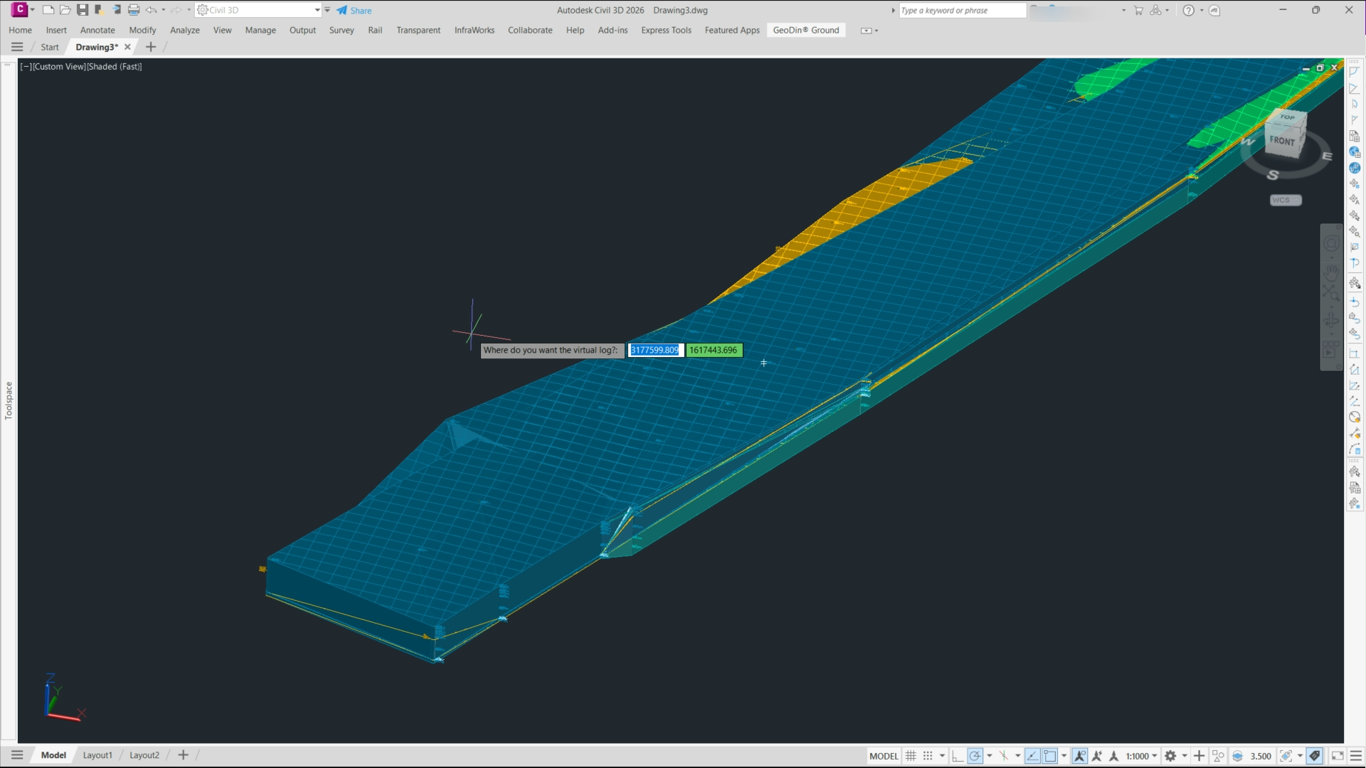
GeoDin Ground, a free Autodesk Civil 3D plug-in, replaces manual borehole imports by directly linking Civil 3D models to GeoDin® geotechnical databases and AGS/Excel borehole logs. The tool generates dynamic 3D subsurface models, including stratigraphy, groundwater levels and geotechnical layers, that update automatically as borehole data change. For designers, this means borehole positions, interpreted soil horizons and material properties are embedded in corridors, alignments and earthworks, reducing data re-entry and improving consistency between geotechnical interpretation and Civil 3D design.
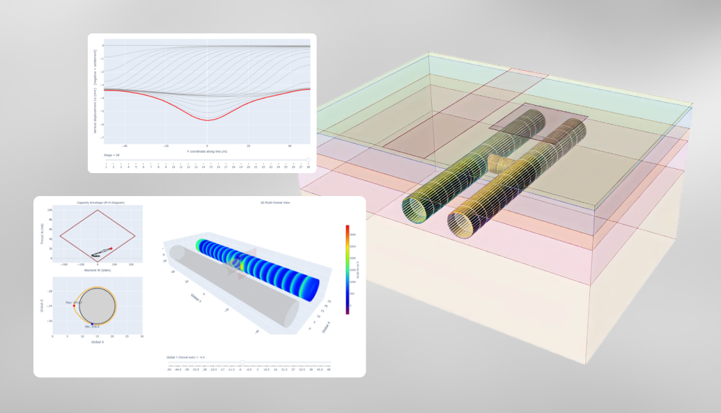
Scripting in RS3 now lets tunnel designers automatically extract lining forces, moments, and displacements at every section along a 3D model, instead of manually interrogating individual cross-sections. Users can generate full lining design envelopes, export results to spreadsheets or custom reports, and rapidly iterate on reinforcement or segment thickness without re-running the finite element analysis. For geotechnical teams, this shifts effort from repetitive post-processing to checking design assumptions, load cases, and ground–structure interaction behaviour across the entire tunnel.
Greenbase’s Envago platform is being deployed to help mining companies comply with Australia’s new mandatory climate reporting regime under AASB S2, which requires disclosure of climate-related risks, Scope 1–3 emissions and governance alongside financial statements. Envago replaces spreadsheet-based workflows by integrating data from site operations, energy meters and procurement systems into a single emissions and ESG reporting environment. For mine operators, this means earlier alignment with AASB S2 assurance expectations and reduced manual reconciliation effort across multiple assets and joint ventures.
Micromine has launched its 2026 Half-Year Release, rolling out upgrades across all eight products in its geology, mine design, scheduling, fleet management and processing software suite as part of a Weir-backed push for a connected mining ecosystem. The release tightens integration between exploration tools such as Micromine Origin and mine planning modules like Micromine Beyond, and links them more directly with operational platforms including Micromine Pitram. For engineers, the move signals more consistent data models and workflows from resource modelling through short-interval control and plant performance monitoring.
Viridien has launched Evergreen Data Solution, an AI‑powered subsurface data platform that automates transformation of large, complex geoscience datasets so asset teams can access and trust results more quickly. Built on Viridien’s existing digital transformation stack, it applies data science workflows to seismic, geological and petrophysical data, targeting shorter interpretation cycle times from exploration through development planning. For mine planners and resource geologists, the tool aims to tighten model update loops, standardise multi‑source inputs and reduce manual data conditioning effort.
Yorkshire Water has appointed Jacobs to a £32M artificial intelligence services framework to support operation and maintenance of its water and wastewater assets across the region. The multi-year agreement is expected to deploy data-driven tools for network monitoring, leakage detection and predictive maintenance on treatment works and buried infrastructure. For civil and geotechnical practitioners, the framework signals growing demand for asset condition analytics, integration of sensor data with hydraulic models, and AI-assisted planning of renewal and resilience upgrades.
Leica has launched a new RTC series of terrestrial 3D laser scanners that combine the speed and on-site registration of the RTC360 with the robustness and higher accuracy of the ScanStation P‑Series, targeting surveying, construction, industrial plants, public safety and infrastructure workflows. Three performance tiers allow users to step up to more demanding scan jobs without replacing their full hardware stack, supporting incremental upgrades across project portfolios. A new Livelink data service, integrated into the Cyclone Field 360 mobile app, streams multi-scanner datasets directly to Hexagon GeoCloud so field, office and cloud models stay synchronised in near real time.
Eclipse Data Innovations has expanded its SourceOne EKPS platform so operations teams at large industrial and mining sites can build custom, AI-powered workflow tools directly from their own time-series and event data using natural language prompts. The upgrade is aimed at tasks such as plant downtime analysis, shift handover reporting and maintenance planning, without needing bespoke coding or separate data-science projects. For engineers, this points to faster deployment of site-specific decision-support apps tightly coupled to existing historians, MES and fleet management systems.
Mark Stuart, joint managing director of Stuart Energy and a specialist in temporary power and equipment hire for construction sites, has joined waste compliance and reuse platform MukAway as a non-executive director. MukAway, which digitises waste movements and reuse documentation for infrastructure and civils projects, is positioning the appointment to support expansion into a wider contractor and plant-hire client base. For geotechnical and civil teams, this signals growing integration between site power logistics, plant fleets and compliant soil and aggregate reuse workflows.
A New Civil Engineer webinar examines how the rapid spread of BIM, CDEs and asset management platforms on major infrastructure schemes is creating a looming “data handover gap” at project close-out. Speakers focus on integrating design, construction and O&M datasets into a single, validated asset information model that meets ISO 19650 requirements rather than leaving owners with fragmented PDFs, native models and sensor feeds. For geotechnical and civil teams, the discussion stresses early definition of data schemas for ground models, as-built records and inspection regimes to avoid costly rework at commissioning.
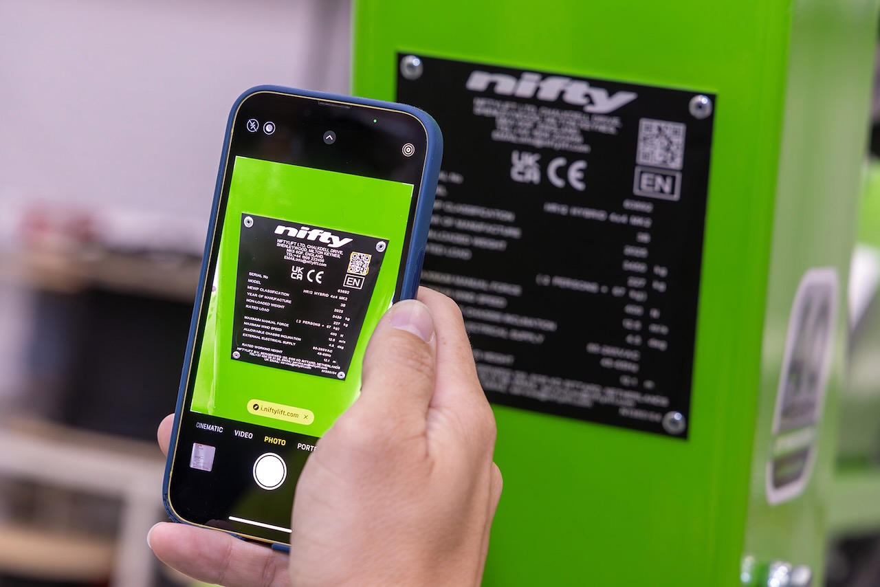
Niftylift has launched MyNifty, a machine-specific online support hub that consolidates manuals, technical documentation, error code lookup, cage overload override reset codes and NiftyPRO video guidance into a single portal. Operators, hire companies and service technicians can access a dedicated page for each model by scanning a QR code on the serial plate or entering the serial number via the Niftylift website, using any mobile device. Most machines in current service already carry QR-coded plates, while older units can be brought into the system through a serial-number QR search tool.
WSP’s AI specialists describe deploying machine learning tools across UK infrastructure portfolios to cut manual inspection and analysis time for engineers. Applications include automated defect detection on large image datasets from bridge and tunnel surveys, and predictive maintenance models that flag high‑risk assets before failure using historic condition, loading and environmental data. The approach is being embedded into WSP’s digital asset management workflows, raising questions for practitioners about data quality, model validation and how to integrate AI outputs into existing inspection and safety regimes.
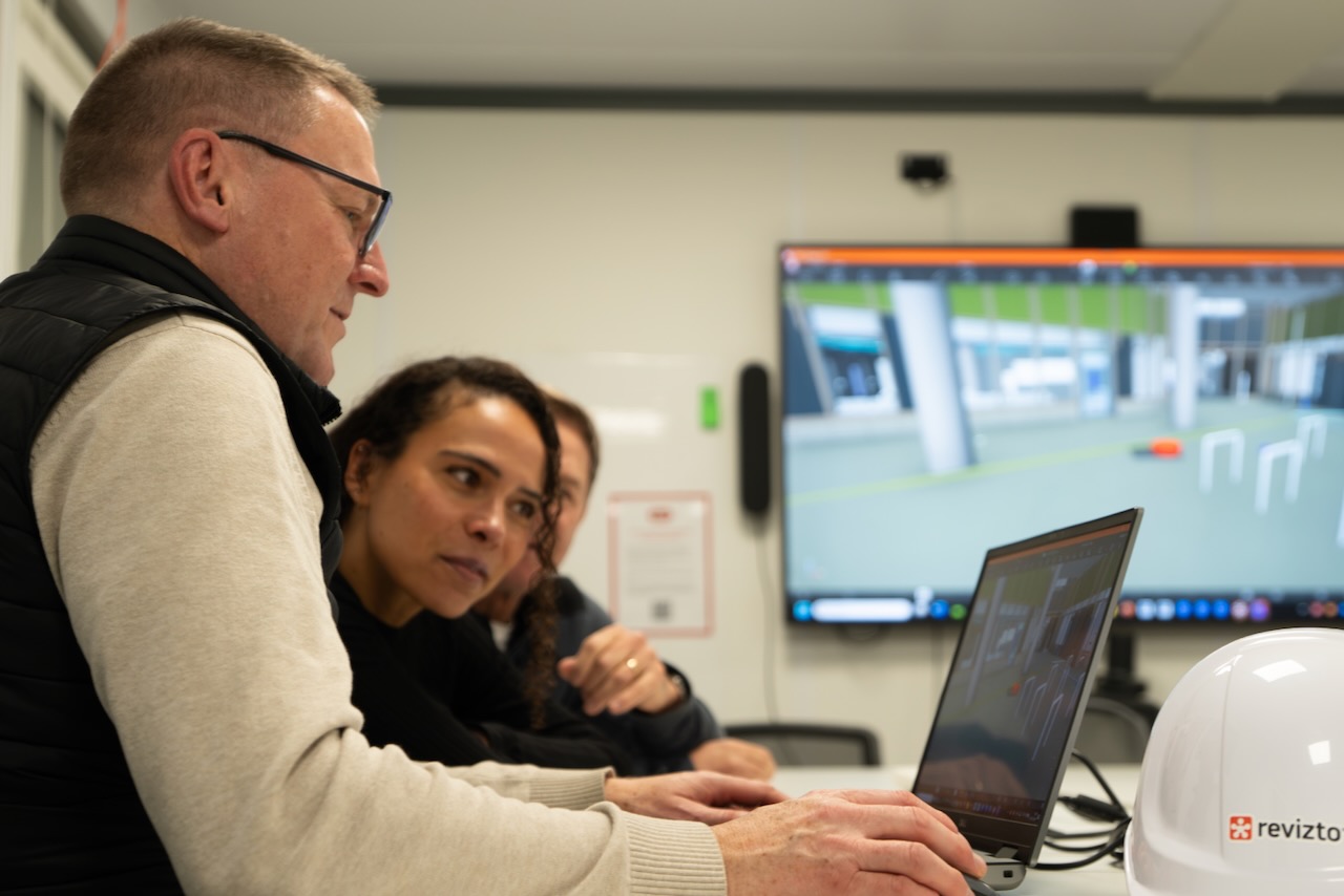
Bouygues UK is using Revizto BIM tools to run live, fully navigable 3D walk-throughs of the 47,000 m² Moorfields and UCL Centre for Eye Health, enabling clinicians to test operating theatre layouts, medical gas outlet positions and patient flows months before work reaches those areas. A single shared model for more than 100 daily onsite users across 20 disciplines has cut clash detection from about a week to 10–15 minutes, with issues logged and resolved in real time. The specialist eye hospital complex is scheduled to open to patients in summer 2027.
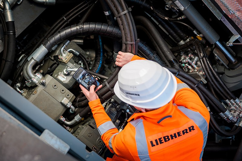
Liebherr Nenzing has launched an AI-based app to identify parts and schedule maintenance for its deep foundation equipment and crawler cranes up to 400 t capacity. Components can be located via photo recognition, QR code scan, multilingual text search in over 100 languages, or item number, with results cross-checked against the official Liebherr parts catalogue to avoid mis-orders when nameplates are damaged. The app also uses machine operating hours to propose upcoming service intervals, listing required parts, consumables and fluids in optimised quantities for each maintenance kit.
WT is expanding its digital project controls to give asset owners near real-time visibility of cost, schedule and risk across multi‑billion‑dollar transport and civil infrastructure programmes, building on its quantity surveying and project advisory work. Integrated dashboards consolidate data from planning, procurement and delivery systems, replacing static monthly reports with live variance tracking and forecast out‑turn costs. For geotechnical and civil teams, this means earlier warning of scope creep, ground risk contingencies and interface clashes, tightening change control on complex major works.
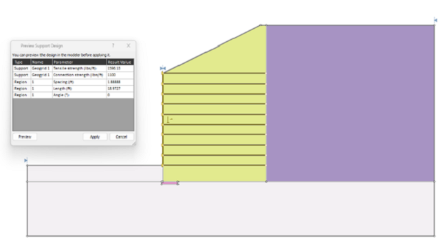
Rocscience has launched Support Designer in Slide2, allowing engineers to specify a target factor of safety for slope or excavation models and automatically compute required support parameters such as bolt length, spacing, and capacity. The tool works with limit equilibrium analyses, adjusting support patterns to meet user-defined FoS rather than relying on manual trial‑and‑error iterations. This shift to target‑driven design could tighten geotechnical optimisation workflows, particularly for complex reinforced slopes, retaining structures, and underground excavations.
RadiXplore is using its Xplor platform to mine decades of underused historical exploration data, aiming to improve discovery rates as new greenfield finds become scarcer and drilling costs rise. Co-founders Russel Menezes and Teryne Young are applying machine learning and pattern-recognition workflows to legacy geochemical assays, drill logs and geophysical surveys to re‑rank targets without commissioning new campaigns. For geologists and explorers, the approach could shift budgets from broad regional drilling to data-driven infill and re-interpretation of existing tenements.
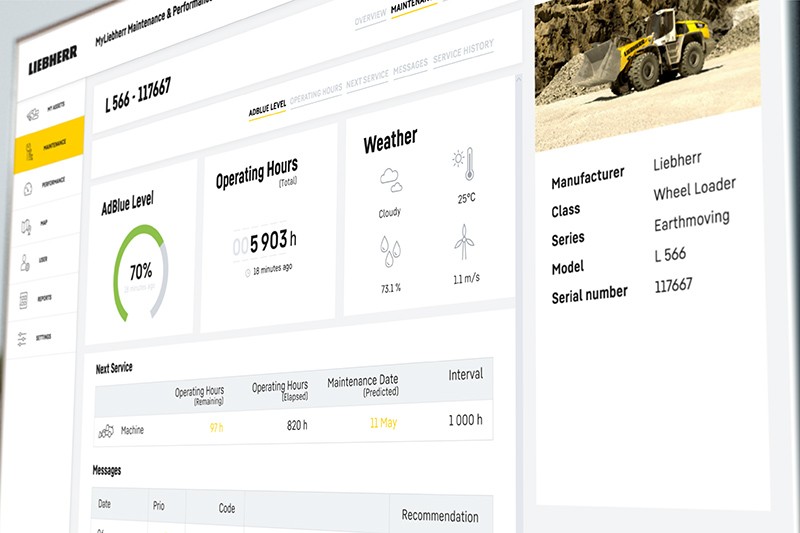
Liebherr is rolling out its expanded MyLiebherr Performance and MyLiebherr Maintenance digital services for earthmoving and material handling fleets in Australia, the UK, Ireland, Canada and the USA, with six months’ free access. The maintenance module gives workshop managers a fleet-wide status overview with traffic light condition coding, cause-specific alerts (e.g. upcoming services, low fluid levels), machine-level service histories and geo-tracked locations to plan bundled interventions. The performance module tracks utilisation, idle hours, fuel consumption versus a global average, and weighing data, enabling group comparisons by machine type or operation to tighten scheduling and cut operating costs.
ABAX has launched ABAX Tachograph to bring 2.5–3.5‑tonne light commercial vehicles into compliance with the EU Mobility Package’s Smart Tachograph 2 (SMT2) rules taking effect on 1 July for international transport. The system integrates LCVs and existing HGVs on a single Smart Operations platform, adding automated tachograph data downloads, violation analysis and driver data management rather than a separate standalone unit. ABAX is targeting fleets facing the 2026 full compliance deadline, aiming to simplify cross‑border operations and reduce manual admin around drivers’ hours enforcement.
Munnelly Group has appointed former Heathrow and Wilson James executive Tom Emery as managing director of Weston Analytics to accelerate its technology, data and innovation strategy across construction logistics and project delivery. Emery, who has led large operational portfolios and digital transformation in aviation, transport, security and workforce operations, will build scalable digital and analytical tools to support faster operational decision-making and better use of site and programme data. CEO Paul David Munnelly said Weston Analytics is central to the group’s Target2030 plan and its role as a full project lifecycle delivery partner.
Advanced investigation methods such as cone penetration testing with pore pressure (CPTu), seismic CPT and high‑resolution pressuremeter testing are generating terabytes of geotechnical data per project, yet much of it remains locked in PDFs, spreadsheets and unstructured lab reports. Centralised, cloud-based platforms with AGS-compliant data models, API links to lab information management systems and automated validation rules are being promoted to standardise borehole, in situ and lab datasets across portfolios. For practitioners, the key gains are faster ground model iteration, more defensible design parameters and easier reuse of legacy site investigation data on brownfield schemes.
CSCS Smart Check has been upgraded with a new API that records GPS coordinates, site ID or name, and the reason for each card scan (pre‑induction, induction, re‑induction, routine check, site entry or other), feeding data from both the web portal and app into approved access and induction systems. The changes are designed to support Building Safety Act compliance and strengthen workforce planning. Combined with CSCS Alliance Workforce Insights, which aggregates anonymised data from over 2.3 million cardholders across 37 schemes, the platform now gives a more granular geographic view of skills and occupational density.
Genesis Energy, New Zealand’s largest electricity retailer and a major generator, has gone live on Workday’s enterprise AI platform to consolidate management of its 1000-plus workforce and financial operations. The deployment brings HR, payroll and finance onto a single cloud system, replacing multiple legacy tools and manual workflows across its thermal, hydro and wind generation assets. For mining and heavy-industry peers, the move signals growing adoption of integrated, AI-enabled back-office platforms to support large asset fleets and complex shift-based labour models.