Geomechanics.io

  • Free Tools
Sign UpLog In

Geomechanics.io

Geomechanics, Streamlined.

© 2026 Geomechanics.io. All rights reserved.

Geomechanics.io

CMRR-ioGEODB-ioHYDROGEO-ioQCDB-ioFree Tools & CalculatorsBlogLatest Industry News

Industries

MiningConstructionTunnelling

Company

Terms of UsePrivacy PolicyLinkedIn
    Projects
    Sustainability
    Safety

    Adaptive pathways in UK coastal management: design lessons for engineers

    January 28, 2026|

    Reviewed by Tom Sullivan

    Adaptive pathways in UK coastal management: design lessons for engineers

    First reported on New Civil Engineer

    30 Second Briefing

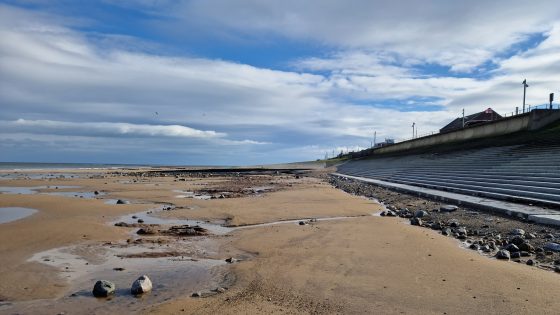
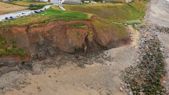
    Storm Goretti’s impact on North East Yorkshire and Eastern Scotland is reviving concern over how Storm Babet in 2023 stripped and reprofiled beaches, exposing the limits of fixed “hold-the-line” coastal defences. Engineers are being urged to adopt adaptive pathways planning, sequencing measures such as managed realignment, dune and beach nourishment, and periodic crest raising rather than relying solely on hard sea walls and rock armour. The approach hinges on trigger points tied to beach levels, overtopping rates and asset condition, enabling long-term, staged investment under rising sea levels and more frequent extreme storms.

    Technical Brief

    • Adaptive pathways require predefined inspection regimes to verify beach profiles and defence condition after each major storm.
    • Governance is framed around Shoreline Management Plans, with adaptive pathways nested within existing SMP policy units.
    • For other UK coasts, similar storm‑driven profile losses would rapidly erode nominal design safety factors for overtopping.

    Our Take

    Within the 36 Hazards stories in our coverage, the UK features frequently for flood and coastal risk, so a long-term adaptive pathways approach in North East Yorkshire and Eastern Scotland is likely to become a reference model for other high-exposure coastlines.

    Using a defined 2025–26 storm season horizon after events like Storm Babet (2023) signals a shift from purely historical design standards towards scenario-based planning, which typically favours modular defences and staged retreat options over single, fixed-line sea walls.

    For UK practitioners, framing schemes around storm seasons rather than individual events tends to strengthen the business case for integrated catchment and coastal projects, allowing safety, sustainability and asset-management budgets to be aligned over multiple funding cycles.

    Geotechnical Software for Modern Teams

    Centralise site data, logs, and lab results with GEODB-io, CMRR-io, and HYDROGEO-io.

    No credit card required.

    • Save and export unlimited calculations
    • Advanced data visualisation
    • Generate professional PDF reports
    • Cloud storage for all your projects

    Prepared by collating external sources, AI-assisted tools, and Geomechanics.io’s proprietary mining database, then reviewed for technical accuracy & edited by our geotechnical team.

    Related Articles

    Melbourne sinkhole investigations: geotechnical lessons for tunnel project teams
    Hazards
    in 4 months

    Melbourne sinkhole investigations: geotechnical lessons for tunnel project teams

    A sinkhole roughly 8–10 m wide and several metres deep has opened on the AJ Burkitt Reserve sporting oval in Heidelberg, directly adjacent to the North East Link tunnel alignment in Melbourne’s northeast. Victorian Infrastructure Delivery Authority has confirmed the “surface hole” is in the vicinity of active tunnelling operations, leading to a work pause while engineers and emergency crews carry out geotechnical investigations and monitoring. No injuries or structural damage have been reported, but the area remains fully cordoned off pending cause determination and stability assessment.

    Colombia rainfall 64% above average: slope failure lessons for engineers
    Hazards
    8 days ago

    Colombia rainfall 64% above average: slope failure lessons for engineers

    Rainfall 64% above the February average has triggered widespread flooding and landslides across Colombia, killing at least 13 people and affecting more than 10,000, with Antioquia, Cundinamarca and Valle del Cauca among the hardest-hit departments. Rivers including the Magdalena and Cauca have overtopped banks, damaging road embankments, bridge approaches and hillside settlements, and forcing evacuations in multiple municipalities. Geotechnical teams face saturated slopes, debris flows and scour at culvert and retaining-wall foundations, with authorities warning of further failures if intense rainfall persists.

    Morocco flooding from extreme rainfall and dam releases: stability lessons for engineers
    Hazards
    11 days ago

    Morocco flooding from extreme rainfall and dam releases: stability lessons for engineers

    More than 140,000 people have been evacuated from low-lying towns and rural communities in northwestern Morocco after extreme rainfall and emergency releases from multiple upstream dams caused major flooding along several river valleys. Rapid drawdown and high downstream discharges are stressing ageing embankment protections, inundating agricultural terraces and damaging road and bridge approaches, with several river crossings reportedly overtopped. Geotechnical teams now face urgent inspections of dam abutments, spillway structures and saturated slopes, alongside rapid debris clearance to reopen key access routes for relief and repair works.

    Related Industries & Products

    Mining

    Geotechnical software solutions for mining operations including CMRR analysis, hydrogeological testing, and data management.

    CMRR-io

    Streamline coal mine roof stability assessments with our cloud-based CMRR software featuring automated calculations, multi-scenario analysis, and collaborative workflows.

    HYDROGEO-io

    Comprehensive hydrogeological testing platform for managing, analysing, and reporting on packer tests, lugeon values, and hydraulic conductivity assessments.

    GEODB-io

    Centralised geotechnical data management solution for storing, accessing, and analysing all your site investigation and material testing data.

    AllGeotechnicalMiningInfrastructureMaterialsHazardsEnvironmentalSoftwarePolicy