Highway 18 rainfall rockfall: geotechnical lessons and mitigation options
Reviewed by Joe Ashwell

First reported on Geoengineer.org – News
30 Second Briefing
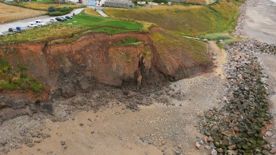
Rainfall-triggered rockfall on Highway 18 in San Bernardino County has blocked lanes and damaged barriers along a steep cut slope, following weeks of intense winter storms that saturated highly fractured granitic and metamorphic rock. Caltrans geotechnical crews report multiple failures from tension cracks and oversteepened slopes above the roadway, with debris reaching the carriageway and impacting existing rockfall fences. Engineers are now assessing options including expanded rock bolting, additional draped mesh, improved surface and subsurface drainage, and revised slope scaling protocols ahead of further atmospheric river events.
Technical Brief
- Field mapping focused on joint set orientation, aperture, and infilled weathered seams controlling kinematic release.
- Investigation teams used drone photogrammetry to map inaccessible faces and delineate active release zones.
- Scaling crews worked under traffic control with spotters and rolling closures to manage rockfall exposure.
- Monitoring options under review include prism targets on key blocks and periodic LiDAR change-detection scans.
- Remediation design is considering upslope catch benches and barrier capacity checks against updated rockfall energy estimates.
- Incident reinforces need for rainfall-intensity thresholds and pre-emptive slope inspections on steep mountain highways.
Our Take
Among the 23 Hazards stories in our database, rainfall-induced failures in the United States are increasingly concentrated in steep, road-cut environments like those in Southern California, suggesting agencies may need to revisit design storm assumptions and rockfall protection standards for mountain highways.
San Bernardino County’s combination of fractured rock slopes and intense storm cells means that even short-duration rainfall can trigger failures, so operators planning projects in similar Southern California terrain are increasingly favouring continuous monitoring and rapid-response slope inspection protocols after major rain events.
Within the 916 tag-matched pieces on Projects–Failure–Safety, several U.S. highway items point to agencies trialling AI-based image and LiDAR analysis for early detection of unstable rock masses, which could be directly applicable to corridors such as Highway 18 where access for manual inspection is limited.
Prepared by collating external sources, AI-assisted tools, and Geomechanics.io’s proprietary mining database, then reviewed for technical accuracy & edited by our geotechnical team.
Related Articles

Related Industries & Products
Mining
Geotechnical software solutions for mining operations including CMRR analysis, hydrogeological testing, and data management.
Construction
Quality control software for construction companies with material testing, batch tracking, and compliance management.
CMRR-io
Streamline coal mine roof stability assessments with our cloud-based CMRR software featuring automated calculations, multi-scenario analysis, and collaborative workflows.
HYDROGEO-io
Comprehensive hydrogeological testing platform for managing, analysing, and reporting on packer tests, lugeon values, and hydraulic conductivity assessments.
GEODB-io
Centralised geotechnical data management solution for storing, accessing, and analysing all your site investigation and material testing data.