Geomechanics.io

  • Free Tools
Sign UpLog In

Geomechanics.io

Geomechanics, Streamlined.

© 2026 Geomechanics.io. All rights reserved.

Geomechanics.io

CMRR-ioGEODB-ioHYDROGEO-ioQCDB-ioFree Tools & CalculatorsBlogLatest Industry News

Industries

MiningConstructionTunnelling

Company

Terms of UsePrivacy PolicyLinkedIn
    AllGeotechnicalMiningInfrastructureMaterialsHazardsEnvironmentalSoftwarePolicy
    Failure
    Safety

    RAIB landslip monitor alert: rapid failure lessons for rail geotechnical teams

    December 22, 2025|

    Reviewed by Tom Sullivan

    RAIB landslip monitor alert: rapid failure lessons for rail geotechnical teams

    First reported on The Construction Index

    30 Second Briefing

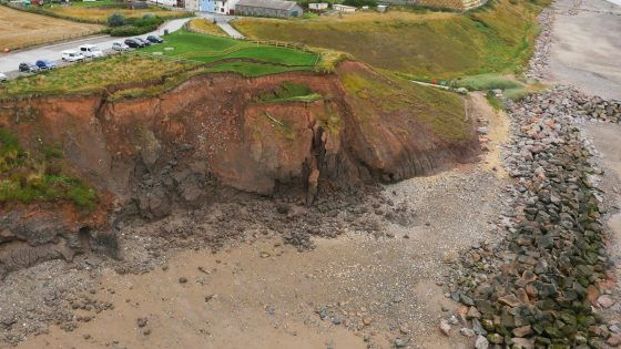
    Railway managers have been warned by the Rail Accident Investigation Branch that Network Rail’s lineside slope monitoring systems may fail to give usable alerts during rapid failures, after an Avanti West Coast train derailed at around 83 mph near Shap Summit on 3 November 2025 when it struck landslip debris. Remote sensors on steel spikes at 2 m spacing recorded sub‑10 mm movements—below the 10–30 mm “green” alert threshold—before being rapidly buried, losing wireless signal and generating no alarm to control. The landslip followed heavy, sustained rainfall that overwhelmed a cutting‑slope drainage channel, and RAIB has urged duty holders to urgently review and, where needed, mitigate these monitoring limitations.

    Technical Brief

    • Remote tilt sensors were installed on steel spikes at 2 m centres along the cutting toe.
    • Monitoring logic used four displacement bands: 10–30 mm (green), 30–60 mm (amber), 60–90 mm (red), >90 mm (black).
    • At Shap the system was physically recording and uploading data but not commissioned to send control-room alerts.
    • Failure mechanism: drainage channel across the upper cutting face lacked capacity, causing saturation and shear failure of the downslope material.

    Our Take

    RAIB’s involvement here, as in the recent Gloucestershire heritage footbridge collapse investigation, signals that UK rail regulators are increasingly scrutinising how temporary works, monitoring systems and operational controls interact, not just the immediate failure mechanism.

    The relatively fine 2 m spacing of steel spike sensors and the multi‑band alert thresholds (10–90 mm) suggest Network Rail is already using comparatively high‑resolution instrumentation on the Shap Summit–Oxenholme corridor, so the key learning is likely to be around alarm logic, response protocols and integration with operations rather than sensor density alone.

    Within our 20 Hazards stories, Network Rail and RAIB feature frequently, indicating that UK mainline infrastructure in areas like the Lake District is generating a disproportionate share of safety‑critical case studies that other asset owners can mine for lessons on earthwork monitoring and risk tolerability at line‑speed operations.

    Geotechnical Software for Modern Teams

    Centralise site data, logs, and lab results with GEODB-io, CMRR-io, and HYDROGEO-io.

    No credit card required.

    • Save and export unlimited calculations
    • Advanced data visualisation
    • Generate professional PDF reports
    • Cloud storage for all your projects

    Prepared by collating external sources, AI-assisted tools, and Geomechanics.io’s proprietary mining database, then reviewed for technical accuracy & edited by our geotechnical team.

    Related Articles

    Melbourne sinkhole investigations: geotechnical lessons for tunnel project teams
    Hazards
    in 4 months

    Melbourne sinkhole investigations: geotechnical lessons for tunnel project teams

    A sinkhole roughly 8–10 m wide and several metres deep has opened on the AJ Burkitt Reserve sporting oval in Heidelberg, directly adjacent to the North East Link tunnel alignment in Melbourne’s northeast. Victorian Infrastructure Delivery Authority has confirmed the “surface hole” is in the vicinity of active tunnelling operations, leading to a work pause while engineers and emergency crews carry out geotechnical investigations and monitoring. No injuries or structural damage have been reported, but the area remains fully cordoned off pending cause determination and stability assessment.

    Colombia rainfall 64% above average: slope failure lessons for engineers
    Hazards
    8 days ago

    Colombia rainfall 64% above average: slope failure lessons for engineers

    Rainfall 64% above the February average has triggered widespread flooding and landslides across Colombia, killing at least 13 people and affecting more than 10,000, with Antioquia, Cundinamarca and Valle del Cauca among the hardest-hit departments. Rivers including the Magdalena and Cauca have overtopped banks, damaging road embankments, bridge approaches and hillside settlements, and forcing evacuations in multiple municipalities. Geotechnical teams face saturated slopes, debris flows and scour at culvert and retaining-wall foundations, with authorities warning of further failures if intense rainfall persists.

    Morocco flooding from extreme rainfall and dam releases: stability lessons for engineers
    Hazards
    11 days ago

    Morocco flooding from extreme rainfall and dam releases: stability lessons for engineers

    More than 140,000 people have been evacuated from low-lying towns and rural communities in northwestern Morocco after extreme rainfall and emergency releases from multiple upstream dams caused major flooding along several river valleys. Rapid drawdown and high downstream discharges are stressing ageing embankment protections, inundating agricultural terraces and damaging road and bridge approaches, with several river crossings reportedly overtopped. Geotechnical teams now face urgent inspections of dam abutments, spillway structures and saturated slopes, alongside rapid debris clearance to reopen key access routes for relief and repair works.

    Related Industries & Products

    Mining

    Geotechnical software solutions for mining operations including CMRR analysis, hydrogeological testing, and data management.

    Construction

    Quality control software for construction companies with material testing, batch tracking, and compliance management.

    CMRR-io

    Streamline coal mine roof stability assessments with our cloud-based CMRR software featuring automated calculations, multi-scenario analysis, and collaborative workflows.

    HYDROGEO-io

    Comprehensive hydrogeological testing platform for managing, analysing, and reporting on packer tests, lugeon values, and hydraulic conductivity assessments.

    GEODB-io

    Centralised geotechnical data management solution for storing, accessing, and analysing all your site investigation and material testing data.