Geomechanics, Streamlined.
© 2026 Geomechanics.io. All rights reserved.
Railway managers have been warned by the Rail Accident Investigation Branch that Network Rail’s lineside slope monitoring systems may fail to give usable alerts during rapid failures, after an Avanti West Coast train derailed at around 83 mph near Shap Summit on 3 November 2025 when it struck landslip debris. Remote sensors on steel spikes at 2 m spacing recorded sub‑10 mm movements—below the 10–30 mm “green” alert threshold—before being rapidly buried, losing wireless signal and generating no alarm to control. The landslip followed heavy, sustained rainfall that overwhelmed a cutting‑slope drainage channel, and RAIB has urged duty holders to urgently review and, where needed, mitigate these monitoring limitations.
Satellite analysis of more than 16,700 US dams shows over 2,500 structures are both in poor condition and classified as high-hazard potential, meaning failure would likely cause loss of life. Geoscientists report many of these ageing embankment and concrete gravity dams lack adequate spillway capacity, suffer from seepage and erosion issues, and sit downstream of growing urban development. The findings point to large unfunded backlogs in dam safety upgrades, with implications for risk-based inspection, emergency drawdown planning and prioritisation of remedial works.
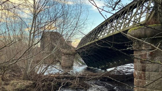
Scour is now confirmed by Moray Council as the likely principal cause of the Garmouth Viaduct collapse over the River Spey on 14 December, after an abrupt change in the river’s flow path is thought to have undermined the masonry or concrete support piers. Engineers are assessing how localised bed erosion and altered hydraulic conditions around the pier foundations triggered the failure. The case will sharpen scrutiny of scour risk assessments, real-time river monitoring and foundation protection measures on older rail and footbridges in dynamic gravel-bed rivers.
A levee breach on the Desimone levee along Washington’s Green River near Tukwila occurred under atmospheric river rainfall, with river levels peaking near 22 feet after a rapid 15‑foot rise in one week, exceeding six decades of recorded stages. The failure, a vehicle‑sized opening caused by internal erosion under prolonged high hydraulic loading, triggered flash flood warnings and evacuations for more than 45,000 residents in low‑lying areas. Emergency works using large sandbags and temporary fill stabilised the embankment, but saturated foundation soils and elevated groundwater leave wider regional levee and slope stability at risk from further storms.
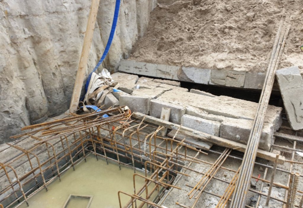
A newly built breeze block retaining wall collapsed into a deep excavation on Old Coast Guard’s Road, Poole, crushing 69-year-old steel-fixer Patrick Grant and prompting a £100,000 fine for principal contractor Matrod Frampton Limited. HSE found the wall had been backfilled before the mortar had set, there was no temporary works design for the wall or other structures, and no temporary works co-ordinator or supervisor had been appointed despite a safety report warning eight days earlier. Rescue was further delayed by reliance on an unstable ladder and the absence of an excavation emergency plan.
Storms Amy and Benjamin have already flooded homes, closed key A-roads and rail links, and overwhelmed ageing culverts and combined sewers, exposing how far UK drainage and flood defences lag current rainfall intensities. Early-season events are overtopping river embankments and bypassing 1-in-100-year design standards in several catchments, forcing emergency pumping and temporary barriers in urban centres. For civil and geotechnical engineers, the message is tighter design margins, more storage and conveyance capacity, and accelerated retrofit of surface water systems before peak winter storms arrive.
A £500 fine has been imposed on McGrath Building & Joinery Contracts Ltd after HSENI found serious asbestos management failings during refurbishment of the Sacred Heart Chapel in Boho, Co. Fermanagh in November 2023. Investigators concluded the principal contractor did not adequately plan, manage or monitor works under Regulation 13(1) of the Construction (Design and Management) Regulations (Northern Ireland) 2016, particularly around identifying and safely removing licensed asbestos. The Enniskillen Magistrates’ Court conviction signals continued regulatory focus on CDM-compliant asbestos surveys and licensed removal on small refurbishment projects.
A magnitude 7.0 earthquake near Yakutat, Alaska, has generated over 160 aftershocks in 24 hours, with shaking felt across southeastern Alaska and into Yukon and British Columbia, raising concern for ageing port, pipeline and road embankment infrastructure on soft coastal sediments. USGS reports shallow crustal rupture along the Fairweather–Queen Charlotte transform system, with peak ground accelerations locally exceeding typical design levels for older structures. Geotechnical teams are prioritising rapid reconnaissance of slope stability, liquefaction-prone deltaic deposits and critical lifelines, including fuel terminals and regional airstrips.
Nuclear Waste Services is exploring an unmanned, highly automated design for the UK’s planned deep Geological Disposal Facility (GDF) for higher-activity radioactive waste, potentially removing routine human presence from underground vaults and access tunnels. Concepts under review include remote-operated emplacement systems, autonomous guided vehicles for waste packages, and fully automated ventilation, monitoring and backfilling operations. For geotechnical and civil designers, this points to layouts, shaft and drift geometries, and ground support that must accommodate robotic handling, long-term remote inspection and minimal maintenance access over many decades.
Prolonged storms in Vietnam have triggered one of the most severe sequences of rainfall-induced hazards in decades, with extensive flooding and more than a dozen landslides reported across Lam Dong province and neighbouring highland areas. Intense, long-duration rainfall on steep, highly weathered slopes has caused rapid slope failures, debris flows and road embankment collapses, cutting key mountain highways and isolating several rural communities. Geotechnical teams now face urgent stabilisation of saturated cut slopes, clearance of landslide debris from narrow carriageways, and reassessment of drainage and slope design criteria for future extreme events.
Record monsoon floods and landslides have killed more than 600 people across Sri Lanka, Indonesia, Thailand and Malaysia, with Sri Lanka’s central highlands and Indonesia’s West Sumatra and South Sulawesi provinces suffering major slope failures. Prolonged rainfall well above seasonal averages has triggered debris flows, embankment breaches and riverbank collapses, overwhelming drainage canals and older flood defences in low-lying urban areas. Geotechnical teams are prioritising emergency slope stabilisation, rapid debris clearance on key highways and reassessment of design rainfall and factor-of-safety assumptions for cut slopes and retaining structures.
A catastrophic landslide in Afaahiti on Tahiti’s southeastern coast has killed at least eight people and left several missing after heavily saturated hillside slopes collapsed during intense rainfall. The failure involved a steep, previously vegetated slope above residential areas, with debris flows destroying multiple homes and blocking local roads that connect to the coastal ring route. Authorities are now assessing residual slope stability, potential for secondary failures, and the need for rapid drainage works, slope reinforcement and revised setback distances for hillside development.
Torrential monsoon rainfall over the past week in North Sumatra has triggered debris-laden flash floods and multiple landslides, killing at least 10 people and leaving six missing in districts including Toba and Samosir. Police and BNPB teams report riverbank failures and slope collapses along road corridors and near settlements, with access to several upland villages cut by washed-out embankments and blocked mountain passes. For geotechnical and civil engineers, the events point to highly saturated residual soils, inadequate slope drainage, and vulnerable transport links in steep catchments during peak monsoon conditions.
Warrenpoint Harbour Authority has been fined £80,000 at Newry Crown Court after 58-year-old employee Kevin McGeough was fatally struck and run over by a 20-tonne Volvo loading shovel at Berth 1 in July 2019. McGeough had been power washing in the dockyard close to the travel route of two large loading shovels transferring wood chip 150 metres across the berth, with one machine carrying about 2 tonnes in a 1.69-metre-high bucket at the time. Investigators found no clearly identified, segregated or physically protected pedestrian routes, exposing workers to uncontrolled vehicle movements.
Heavy rainfall in Sri Lanka’s Central Province triggered a fatal landslide that killed four people when a saturated slope above a narrow local road collapsed onto passing vehicles, according to the Disaster Management Centre. The failure followed several days of intense monsoonal rain that exceeded typical seasonal totals, with local authorities already recording multiple smaller slope instabilities and debris flows in adjacent hill districts. Geotechnical teams are now prioritising rapid slope inspections, temporary drainage and toe protection on weathered residual soils along rural road corridors that lack engineered retaining structures.
A major landslide on the 33‑kilometre Khanh Le Pass in central Viet Nam buried a passenger bus late on Sunday, killing six people and injuring 19. The mountain road, cut into steep terrain with deeply weathered residual soils, is already known for frequent rockfalls and debris slides during intense rainfall. The incident highlights urgent needs for detailed slope stability assessment, improved drainage, and engineered protection measures such as retaining structures, rockfall barriers, and real‑time monitoring on this and similar high‑risk corridors.
A severe geomagnetic storm forecast for mid-November 2025, rated G4–G5 and driven by multiple coronal mass ejections, is prompting grid operators to pre-emptively isolate selected high-voltage transmission circuits to protect large transformers while keeping consumer supply stable. Induced geomagnetically driven currents in long conductors threaten high‑latitude power networks, with likely temporary shutdowns or derating as protection relays trip on rapid voltage and frequency fluctuations. Satellite-based GPS, high‑frequency radio and mobile networks may suffer timing errors and intermittent loss, stressing geotechnical operations that depend on precise positioning, remote monitoring and emergency communications.
Heavy rainfall across Indonesia’s Central Java has triggered multiple landslides, with the most severe in Cibeunying village burying at least 35 houses and cutting a key district road. Steep residual soil slopes, shallow colluvial deposits and deforested hillsides failed after several days of intense rain, with local officials reporting tension cracks and minor slips on adjacent slopes now at risk of progressive failure. Emergency works focus on debris clearance, temporary gabion retaining structures and drainage channels, but long-term stabilisation will require detailed geotechnical mapping and slope zoning.
Asbestos-contaminated coloured play sand has triggered widespread recalls and temporary closures of schools and preschools across Australia and New Zealand after laboratory tests detected tremolite and chrysotile fibres. Authorities are tracing supply chains for multiple imported sand batches and conducting confirmatory bulk and air sampling, with some sites requiring full playground cordons and controlled removal of loose fill. Geotechnical and environmental consultants are being engaged for asbestos risk assessments, remediation design and validation testing, particularly where sand was used over unsealed subgrades or near drainage lines.
Rising water levels in Kenya’s Lake Naivasha have submerged large parts of Kihoto estate, displacing about 7,000 people and forcing the use of tourist boats for evacuation as access roads and ground floors are inundated. Local officials report that the lake has been rising for more than a decade, with recent levels overtopping informal embankments and flooding masonry houses, pit latrines and septic systems. Geotechnical concerns now centre on saturated foundations, slope instability on reclaimed lakebed plots, and contamination risks from submerged sanitation infrastructure.
Mount Semeru in East Java has been raised to the highest alert level after entering a new phase of intense activity, with ash columns reported above several kilometres and villages blanketed in thick deposits. Authorities have ordered mass evacuations from settlements on the volcano’s flanks and along key river valleys that previously channelled lahars in the 2021 eruption. For geotechnical and civil teams, priority issues are ash loading on lightweight roofs, rapid assessment of slope stability on ash-covered road embankments, and lahar risk to bridges and culverts.