Geomechanics.io

  • Free Tools
Sign UpLog In

Geomechanics.io

Geomechanics, Simplified.

© 2025 Geomechanics.io. All rights reserved.

Geomechanics.io

CMRR-ioGEODB-ioHYDROGEO-ioQCDB-ioFree Tools & CalculatorsBlogLatest Industry News

Industries

MiningConstructionTunnelling

Company

Terms of UsePrivacy PolicyLinkedIn
    AllGeotechnicalMiningInfrastructureMaterialsHazardsEnvironmentalSoftwarePolicy
    Projects
    Failure
    Safety

    Llangollen Canal embankment failure: breach mechanics and lessons for engineers

    December 22, 2025|

    Reviewed by Joe Ashwell

    Llangollen Canal embankment failure: breach mechanics and lessons for engineers

    First reported on Geoengineer.org – News

    30 Second Briefing

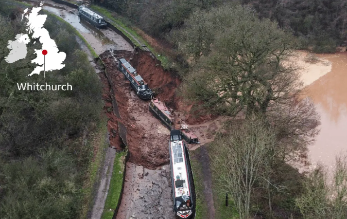
    A man-made embankment on the Llangollen Canal near Whitchurch, Shropshire, failed in the early hours of Monday, creating a large breach that rapidly drained a several‑kilometre pound and triggered a major incident response. The failure occurred on a raised canal section over low-lying farmland, with water overtopping and eroding the embankment before a full breach developed, flooding adjacent fields and damaging access tracks. Canal & River Trust engineers have isolated the affected reach with stop planks and are assessing embankment stability, seepage paths and repair options under constrained access conditions.

    Technical Brief

    • Incident underlines the need for systematic risk-based inspection of ageing canal embankments, especially raised sections over third-party land.

    Our Take

    Within our 22 Hazards stories, the Llangollen Canal failure stands out as one of the few UK civil infrastructure incidents, whereas most hazards coverage is skewed towards mine tailings and pit wall stability rather than navigation embankments.

    For operators in Shropshire and wider UK waterway infrastructure, this type of canal embankment failure highlights similar geotechnical risk modes to older flood embankments and tailings dams, especially where historic earthworks pre-date modern design standards and surveillance practices.

    Given the ‘Projects / Failure / Safety’ tagging, asset owners along the Llangollen Canal corridor may face closer scrutiny of inspection regimes, seepage monitoring, and emergency drawdown provisions, aligning them more with the risk management expectations already common in major mining earthworks projects in our database.

    Geotechnical Software for Modern Teams

    Centralise site data, logs, and lab results with GEODB-io, CMRR-io, and HYDROGEO-io.

    No credit card required.

    • Save and export unlimited calculations
    • Advanced data visualisation
    • Generate professional PDF reports
    • Cloud storage for all your projects

    Prepared by collating external sources, AI-assisted tools, and Geomechanics.io’s proprietary mining database, then reviewed for technical accuracy & edited by our geotechnical team.

    Related Articles

    Shap lineside monitoring warning: slope stability lessons for rail engineers
    Hazards
    2 days ago

    Shap lineside monitoring warning: slope stability lessons for rail engineers

    Lineside monitoring systems on parts of Britain’s rail network may fail to detect embankment or cutting slope movements during extreme rainfall, the Rail Accident Investigation Branch has warned following the 3 November passenger train derailment near Shap, Cumbria. The warning concerns remote condition monitoring equipment installed to trigger alerts for ground instability, which did not prevent the derailment. Geotechnical and asset engineers are being urged to review sensor siting, trigger thresholds and system performance in severe weather, particularly on high-risk slopes.

    RAIB landslip monitor alert: rapid failure lessons for rail geotechnical teams
    Hazards
    3 days ago

    RAIB landslip monitor alert: rapid failure lessons for rail geotechnical teams

    Railway managers have been warned by the Rail Accident Investigation Branch that Network Rail’s lineside slope monitoring systems may fail to give usable alerts during rapid failures, after an Avanti West Coast train derailed at around 83 mph near Shap Summit on 3 November 2025 when it struck landslip debris. Remote sensors on steel spikes at 2 m spacing recorded sub‑10 mm movements—below the 10–30 mm “green” alert threshold—before being rapidly buried, losing wireless signal and generating no alarm to control. The landslip followed heavy, sustained rainfall that overwhelmed a cutting‑slope drainage channel, and RAIB has urged duty holders to urgently review and, where needed, mitigate these monitoring limitations.

    Over 2,500 poor-condition US dams: satellite risk insights for dam engineers
    Hazards
    4 days ago

    Over 2,500 poor-condition US dams: satellite risk insights for dam engineers

    Satellite analysis of more than 16,700 US dams shows over 2,500 structures are both in poor condition and classified as high-hazard potential, meaning failure would likely cause loss of life. Geoscientists report many of these ageing embankment and concrete gravity dams lack adequate spillway capacity, suffer from seepage and erosion issues, and sit downstream of growing urban development. The findings point to large unfunded backlogs in dam safety upgrades, with implications for risk-based inspection, emergency drawdown planning and prioritisation of remedial works.

    Related Industries & Products

    Mining

    Geotechnical software solutions for mining operations including CMRR analysis, hydrogeological testing, and data management.

    Construction

    Quality control software for construction companies with material testing, batch tracking, and compliance management.

    CMRR-io

    Streamline coal mine roof stability assessments with our cloud-based CMRR software featuring automated calculations, multi-scenario analysis, and collaborative workflows.

    HYDROGEO-io

    Comprehensive hydrogeological testing platform for managing, analysing, and reporting on packer tests, lugeon values, and hydraulic conductivity assessments.

    GEODB-io

    Centralised geotechnical data management solution for storing, accessing, and analysing all your site investigation and material testing data.