Geomechanics.io

  • Free Tools
Sign UpLog In

Geomechanics.io

Geomechanics, Simplified.

© 2025 Geomechanics.io. All rights reserved.

Geomechanics.io

CMRR-ioGEODB-ioHYDROGEO-ioQCDB-ioFree Tools & CalculatorsBlogLatest Industry News

Industries

MiningConstructionTunnelling

Company

Terms of UsePrivacy PolicyLinkedIn
    Failure
    Safety
    Projects

    Shap lineside monitoring warning: slope stability lessons for rail engineers

    December 22, 2025|

    Reviewed by Joe Ashwell

    Shap lineside monitoring warning: slope stability lessons for rail engineers

    First reported on New Civil Engineer

    30 Second Briefing

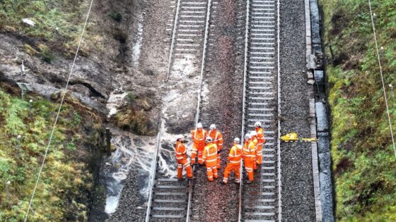
    Lineside monitoring systems on parts of Britain’s rail network may fail to detect embankment or cutting slope movements during extreme rainfall, the Rail Accident Investigation Branch has warned following the 3 November passenger train derailment near Shap, Cumbria. The warning concerns remote condition monitoring equipment installed to trigger alerts for ground instability, which did not prevent the derailment. Geotechnical and asset engineers are being urged to review sensor siting, trigger thresholds and system performance in severe weather, particularly on high-risk slopes.

    Technical Brief

    • Inspectors are reviewing how monitoring hardware is mounted relative to potential slip planes and failure geometries.
    • Trigger logic and alarm hierarchies are being examined for masking, suppression or filtering of transient instability signals.
    • Monitoring resilience in severe weather is being checked, including power supply robustness and communications redundancy.
    • Remedial options under consideration include relocating sensors, adding independent geotechnical instruments and revising threshold settings.

    Our Take

    RAIB’s warning on lineside slope monitoring at Shap sits alongside its recent findings on the Gloucestershire heritage footbridge strike, signalling that UK rail risk exposure is currently split between geotechnical instability and worksite/plant interface errors rather than a single dominant failure mode.

    With Network Rail named in the related Shap investigation summary, this incident increases pressure on British route asset managers to verify whether existing slope monitoring specifications are adequate for rapid failures in high‑rainfall corridors such as Cumbria, rather than relying on generic national standards.

    Among the 21 Hazards stories in our coverage, RAIB appears repeatedly, suggesting that its recommendations are now a primary driver for safety‑critical changes on UK rail projects, especially where legacy infrastructure and modern monitoring systems intersect.

    Geotechnical Software for Modern Teams

    Centralise site data, logs, and lab results with GEODB-io, CMRR-io, and HYDROGEO-io.

    No credit card required.

    • Save and export unlimited calculations
    • Advanced data visualisation
    • Generate professional PDF reports
    • Cloud storage for all your projects

    Prepared by collating external sources, AI-assisted tools, and Geomechanics.io’s proprietary mining database, then reviewed for technical accuracy & edited by our geotechnical team.

    Related Articles

    RAIB landslip monitor alert: rapid failure lessons for rail geotechnical teams
    Hazards
    1 day ago

    RAIB landslip monitor alert: rapid failure lessons for rail geotechnical teams

    Railway managers have been warned by the Rail Accident Investigation Branch that Network Rail’s lineside slope monitoring systems may fail to give usable alerts during rapid failures, after an Avanti West Coast train derailed at around 83 mph near Shap Summit on 3 November 2025 when it struck landslip debris. Remote sensors on steel spikes at 2 m spacing recorded sub‑10 mm movements—below the 10–30 mm “green” alert threshold—before being rapidly buried, losing wireless signal and generating no alarm to control. The landslip followed heavy, sustained rainfall that overwhelmed a cutting‑slope drainage channel, and RAIB has urged duty holders to urgently review and, where needed, mitigate these monitoring limitations.

    Over 2,500 poor-condition US dams: satellite risk insights for dam engineers
    Hazards
    2 days ago

    Over 2,500 poor-condition US dams: satellite risk insights for dam engineers

    Satellite analysis of more than 16,700 US dams shows over 2,500 structures are both in poor condition and classified as high-hazard potential, meaning failure would likely cause loss of life. Geoscientists report many of these ageing embankment and concrete gravity dams lack adequate spillway capacity, suffer from seepage and erosion issues, and sit downstream of growing urban development. The findings point to large unfunded backlogs in dam safety upgrades, with implications for risk-based inspection, emergency drawdown planning and prioritisation of remedial works.

    Garmouth Viaduct scour collapse: hydraulic failure lessons for bridge engineers
    Hazards
    5 days ago

    Garmouth Viaduct scour collapse: hydraulic failure lessons for bridge engineers

    Scour is now confirmed by Moray Council as the likely principal cause of the Garmouth Viaduct collapse over the River Spey on 14 December, after an abrupt change in the river’s flow path is thought to have undermined the masonry or concrete support piers. Engineers are assessing how localised bed erosion and altered hydraulic conditions around the pier foundations triggered the failure. The case will sharpen scrutiny of scour risk assessments, real-time river monitoring and foundation protection measures on older rail and footbridges in dynamic gravel-bed rivers.

    Related Industries & Products

    Mining

    Geotechnical software solutions for mining operations including CMRR analysis, hydrogeological testing, and data management.

    Construction

    Quality control software for construction companies with material testing, batch tracking, and compliance management.

    CMRR-io

    Streamline coal mine roof stability assessments with our cloud-based CMRR software featuring automated calculations, multi-scenario analysis, and collaborative workflows.

    HYDROGEO-io

    Comprehensive hydrogeological testing platform for managing, analysing, and reporting on packer tests, lugeon values, and hydraulic conductivity assessments.

    GEODB-io

    Centralised geotechnical data management solution for storing, accessing, and analysing all your site investigation and material testing data.

    AllGeotechnicalMiningInfrastructureMaterialsHazardsEnvironmentalSoftwarePolicy