Geomechanics.io

  • Free Tools
Sign UpLog In

Geomechanics.io

Geomechanics, Simplified.

© 2025 Geomechanics.io. All rights reserved.

Geomechanics.io

CMRR-ioGEODB-ioHYDROGEO-ioQCDB-ioFree Tools & CalculatorsBlogLatest Industry News

Industries

MiningConstructionTunnelling

Company

Terms of UsePrivacy PolicyLinkedIn
    AllGeotechnicalMiningInfrastructureMaterialsHazardsEnvironmentalSoftwarePolicy
    Projects
    Safety
    Sustainability

    UK unmanned nuclear waste GDF: design and safety notes for tunnel engineers

    December 10, 2025|

    Reviewed by Joe Ashwell

    UK unmanned nuclear waste GDF: design and safety notes for tunnel engineers

    First reported on New Civil Engineer

    30 Second Briefing

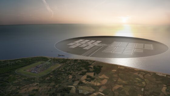
    Nuclear Waste Services is exploring an unmanned, highly automated design for the UK’s planned deep Geological Disposal Facility (GDF) for higher-activity radioactive waste, potentially removing routine human presence from underground vaults and access tunnels. Concepts under review include remote-operated emplacement systems, autonomous guided vehicles for waste packages, and fully automated ventilation, monitoring and backfilling operations. For geotechnical and civil designers, this points to layouts, shaft and drift geometries, and ground support that must accommodate robotic handling, long-term remote inspection and minimal maintenance access over many decades.

    Technical Brief

    • Safety case development must show passive protection of workers and public without relying on underground intervention.
    • Remote systems must remain operable and fail-safe over repository timescales measured in many decades.
    • Design teams must treat underground areas as permanently inaccessible, influencing fire, egress and rescue strategies.
    • Monitoring systems will need redundancy and diversity to detect anomalies without physical inspection access.
    • Automation reduces occupational exposure underground but transfers risk to control software, cyber security and interfaces.
    • Lessons from this GDF concept could inform automation and exclusion strategies in other high-hazard underground works.

    Our Take

    Within the 12 Hazards stories in our database, the United Kingdom features more often in relation to regulatory and design debates than actual construction incidents, so any move by Nuclear Waste Services towards an ‘unmanned’ deep facility will likely be scrutinised mainly through a safety-case and governance lens rather than recent accident history.

    Across the 533 tag-matched pieces on Projects, Safety and Sustainability, long-lived underground facilities (mines, caverns, repositories) increasingly rely on remote monitoring and reduced manning, suggesting NWS can draw on maturing practices from deep mining and hydrocarbon storage when justifying remote or autonomous operation concepts.

    For a UK repository, an unmanned operational concept would shift a large part of the safety argument from occupational risk management to long-term system reliability and maintainability, meaning geotechnical design, passive barrier performance and remote inspection regimes will carry more weight than conventional underground workforce safety measures.

    Geotechnical Software for Modern Teams

    Centralise site data, logs, and lab results with GEODB-io, CMRR-io, and HYDROGEO-io.

    No credit card required.

    • Save and export unlimited calculations
    • Advanced data visualisation
    • Generate professional PDF reports
    • Cloud storage for all your projects

    Prepared by collating external sources, AI-assisted tools, and Geomechanics.io’s proprietary mining database, then reviewed for technical accuracy & edited by our geotechnical team.

    Related Articles

    Alaska M7.0 earthquake: geotechnical risk takeaways for coastal infrastructure
    Hazards
    4 days ago

    Alaska M7.0 earthquake: geotechnical risk takeaways for coastal infrastructure

    A magnitude 7.0 earthquake near Yakutat, Alaska, has generated over 160 aftershocks in 24 hours, with shaking felt across southeastern Alaska and into Yukon and British Columbia, raising concern for ageing port, pipeline and road embankment infrastructure on soft coastal sediments. USGS reports shallow crustal rupture along the Fairweather–Queen Charlotte transform system, with peak ground accelerations locally exceeding typical design levels for older structures. Geotechnical teams are prioritising rapid reconnaissance of slope stability, liquefaction-prone deltaic deposits and critical lifelines, including fuel terminals and regional airstrips.

    Vietnam landslides after extreme rainfall: slope stability lessons for engineers
    Hazards
    7 days ago

    Vietnam landslides after extreme rainfall: slope stability lessons for engineers

    Prolonged storms in Vietnam have triggered one of the most severe sequences of rainfall-induced hazards in decades, with extensive flooding and more than a dozen landslides reported across Lam Dong province and neighbouring highland areas. Intense, long-duration rainfall on steep, highly weathered slopes has caused rapid slope failures, debris flows and road embankment collapses, cutting key mountain highways and isolating several rural communities. Geotechnical teams now face urgent stabilisation of saturated cut slopes, clearance of landslide debris from narrow carriageways, and reassessment of drainage and slope design criteria for future extreme events.

    Record floods and landslides in Southeast Asia: geotechnical lessons for engineers
    Hazards
    11 days ago

    Record floods and landslides in Southeast Asia: geotechnical lessons for engineers

    Record monsoon floods and landslides have killed more than 600 people across Sri Lanka, Indonesia, Thailand and Malaysia, with Sri Lanka’s central highlands and Indonesia’s West Sumatra and South Sulawesi provinces suffering major slope failures. Prolonged rainfall well above seasonal averages has triggered debris flows, embankment breaches and riverbank collapses, overwhelming drainage canals and older flood defences in low-lying urban areas. Geotechnical teams are prioritising emergency slope stabilisation, rapid debris clearance on key highways and reassessment of design rainfall and factor-of-safety assumptions for cut slopes and retaining structures.

    Related Industries & Products

    Mining

    Geotechnical software solutions for mining operations including CMRR analysis, hydrogeological testing, and data management.

    Construction

    Quality control software for construction companies with material testing, batch tracking, and compliance management.

    CMRR-io

    Streamline coal mine roof stability assessments with our cloud-based CMRR software featuring automated calculations, multi-scenario analysis, and collaborative workflows.

    HYDROGEO-io

    Comprehensive hydrogeological testing platform for managing, analysing, and reporting on packer tests, lugeon values, and hydraulic conductivity assessments.

    GEODB-io

    Centralised geotechnical data management solution for storing, accessing, and analysing all your site investigation and material testing data.