Geomechanics.io

  • Free Tools
Sign UpLog In

    Geomechanics.io

    Geomechanics, Streamlined.

    © 2026 Geomechanics.io. All rights reserved.

    Geomechanics.io

    CMRR-ioGEODB-ioHYDROGEO-ioQCDB-ioFree Tools & CalculatorsBlogLatest Industry News

    Industries

    MiningConstructionTunnelling

    Company

    Terms of UsePrivacy PolicyLinkedIn
    Projects
    Product
    Safety

    RETTAR 3D spatial sensing: stockyard design, safety and control notes for mines

    April 30, 2026|

    Reviewed by Joe Ashwell

    RETTAR 3D spatial sensing: stockyard design, safety and control notes for mines

    First reported on International Mining – News

    30 Second Briefing

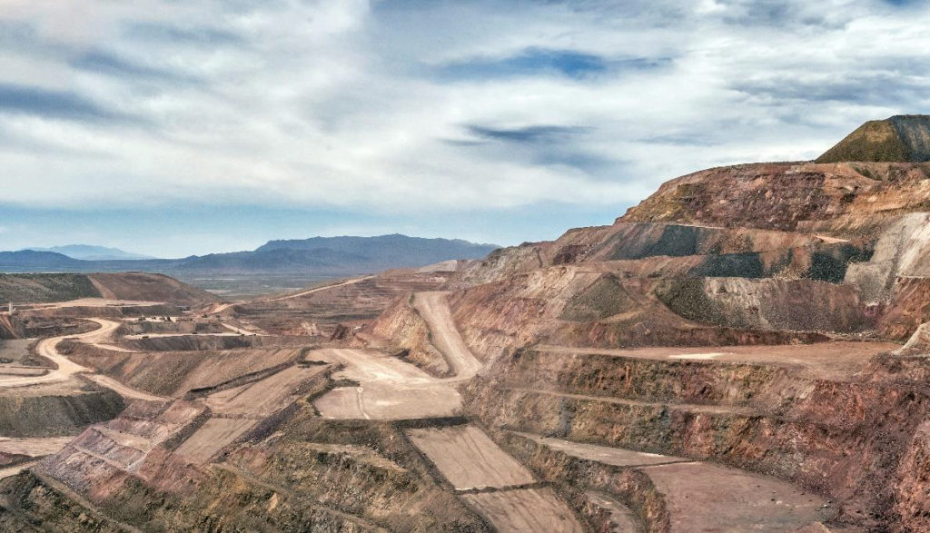
    Beijing-based RETTAR is deploying 3D spatial sensing systems in mines and aggregate stockyards to automate volumetric measurement and material tracking, replacing manual surveys hampered by low visibility and data lag. Using fixed LiDAR scanners and mobile platforms to generate high-density point clouds, the technology delivers near real-time stockpile models and reconciled tonnage estimates across crushers, conveyors and storage pads. For mine planners and plant operators, this enables tighter inventory control, faster reconciliation cycles and reduced on-foot exposure around active stockpiles and loading areas.

    Technical Brief

    • Similar 3D sensing deployments in other large stockyards could support compliance with site-specific isolation, traffic and working-at-height procedures.

    Our Take

    RETTAR’s 3D spatial sensing push sits within a large pool of 2335 tag-matched ‘Projects / Product / Safety’ pieces in our coverage, but relatively few of those focus on stockyard environments, suggesting this could fill a niche in surface material-handling risk management rather than just underground collision avoidance.

    International Mining’s role here mirrors its presence in coverage of Boliden’s ‘green fleets’, indicating that RETTAR’s technology is being positioned alongside other enabling systems for lower-emission, highly automated operations rather than as a standalone safety bolt-on.

    With top mining CEOs convening at the World Mining Congress 2026 under International Mining’s media umbrella, RETTAR’s mine and stockyard sensing offering is likely to be showcased to decision-makers who are already evaluating integrated digital safety platforms across global portfolios.

    Geotechnical Software for Modern Teams

    Centralise site data, logs, and lab results with GEODB-io, CMRR-io, and HYDROGEO-io.

    No credit card required.

    • Save and export unlimited calculations
    • Advanced data visualisation
    • Generate professional PDF reports
    • Cloud storage for all your projects

    Prepared by collating external sources, AI-assisted tools, and Geomechanics.io’s proprietary mining database, then reviewed for technical accuracy & edited by our geotechnical team.

    Related Articles

    Integra’s 74% reserve lift at Florida Canyon: project economics for mine planners
    Mining
    about 15 hours ago

    Integra’s 74% reserve lift at Florida Canyon: project economics for mine planners

    Integra Resources’ updated feasibility study for the Florida Canyon heap leach mine in Nevada lifts proven and probable reserves 74% to 1.1 million oz at 0.31 g/t, raises planned output to 82,000 oz gold per year over eight years, and boosts the 5% NPV to US$601 million using a US$4,200/oz price. All-in sustaining costs climb 43% to US$2,331/oz with recovery steady at 62%, but post-tax free cash flow is projected at US$800 million, averaging US$90 million annually. Integra is drilling 42,500 metres around the existing operation to grow resources and fund its DeLamar gold-silver project in Idaho.

    DRC critical minerals strategy: price-setting and supply risks for mine planners
    Mining
    about 15 hours ago

    DRC critical minerals strategy: price-setting and supply risks for mine planners

    Democratic Republic of Congo has shifted from price-taker to price-setter in cobalt by imposing ARECOMS-managed export quotas and planning state stockpiles of cobalt, coltan and germanium. Cobalt prices have climbed from about $21,000/t in early 2025 to just over $56,000/t, with Kinshasa forecasting $2.3 billion in fiscal revenues this year versus an estimated $617 million without intervention. Advisory input from Vectus Global and new investment moves such as Virtus Minerals’ acquisition of Chemaf signal tighter supply discipline and a push for higher value-added partnerships.

    Ground view Kazakhstan: digitised Soviet data and reserve codes for explorers
    Mining
    about 15 hours ago

    Ground view Kazakhstan: digitised Soviet data and reserve codes for explorers

    Kazakhstan is racing to digitise a vast Soviet-era geological archive, with 1960s seismic data still stored on magnetic tape that can only be read on perhaps three surviving machines using playback needles no longer manufactured since the Brezhnev era. The National Geological Service aims to convert millions of pages of hand-drawn, non-standardised maps into polygons, vectors and points for AI-driven targeting of critical minerals, while also restating Soviet GKZ-classified reserves into KAZRC, JORC or NI 43‑101, with only about 143 of 400–500 major deposits converted so far. More than US$17 billion in recent US–Kazakh trade and investment deals, plus a new memorandum with Saudi Arabia, signal that access to this “pre-paid exploration” data is becoming a key competitive factor for mid-tier and junior explorers.

    Related Industries & Products

    Mining

    Geotechnical software solutions for mining operations including CMRR analysis, hydrogeological testing, and data management.

    Tunnelling

    Specialised solutions for tunnelling projects including grout mix design, hydrogeological analysis, and quality control.

    CMRR-io

    Streamline coal mine roof stability assessments with our cloud-based CMRR software featuring automated calculations, multi-scenario analysis, and collaborative workflows.

    HYDROGEO-io

    Comprehensive hydrogeological testing platform for managing, analysing, and reporting on packer tests, lugeon values, and hydraulic conductivity assessments.

    GEODB-io

    Centralised geotechnical data management solution for storing, accessing, and analysing all your site investigation and material testing data.

    AllGeotechnicalMiningInfrastructureMaterialsHazardsEnvironmentalSoftwarePolicy