Geomechanics.io

  • Free Tools
Sign UpLog In

Geomechanics.io

Geomechanics, Streamlined.

© 2026 Geomechanics.io. All rights reserved.

Geomechanics.io

CMRR-ioGEODB-ioHYDROGEO-ioQCDB-ioFree Tools & CalculatorsBlogLatest Industry News

Industries

MiningConstructionTunnelling

Company

Terms of UsePrivacy PolicyLinkedIn
    Research
    Safety
    Sustainability

    Ordnance Survey flood risk mapping: resilience takeaways for UK transport engineers

    March 17, 2026|

    Reviewed by Tom Sullivan

    Ordnance Survey flood risk mapping: resilience takeaways for UK transport engineers

    First reported on New Civil Engineer

    30 Second Briefing

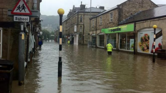
    New analysis by Ordnance Survey maps how climate-driven flood risk intersects with England’s strategic roads and railways, calling for a “clear, forward-looking understanding” of exposure. Using its national topographic database and elevation models, OS identifies low-lying corridors, embankments and cuttings where overtopping, scour and trackbed saturation could disrupt key routes. The work signals a need to integrate updated flood extents into asset management, drainage design and resilience upgrades for highways structures and rail earthworks.

    Technical Brief

    • Similar geospatial screening could be extended to depots, stations and maintenance compounds sharing the same corridors.

    Our Take

    With 34 Hazards stories in our database, the United Kingdom features heavily in flood and climate‑exposure pieces, so Ordnance Survey’s call for forward‑looking risk assessment is likely to feed directly into how UK asset owners benchmark roads and railways against other climate‑sensitive infrastructure.

    New Civil Engineer also appears in coverage of National Highways’ £11bn Lower Thames Crossing sustainability framework, suggesting that OS’s flood‑risk work could be picked up in similar whole‑life resilience and carbon baselining approaches for major English road schemes.

    Many of the 803 tag‑matched Research/Safety/Sustainability items now involve geospatial data and, increasingly, AI, so OS’s analysis is well‑placed to be integrated with predictive tools for route planning and maintenance prioritisation across England’s transport network.

    Geotechnical Software for Modern Teams

    Centralise site data, logs, and lab results with GEODB-io, CMRR-io, and HYDROGEO-io.

    No credit card required.

    • Save and export unlimited calculations
    • Advanced data visualisation
    • Generate professional PDF reports
    • Cloud storage for all your projects

    Prepared by collating external sources, AI-assisted tools, and Geomechanics.io’s proprietary mining database, then reviewed for technical accuracy & edited by our geotechnical team.

    Related Articles

    Construction worker fatalities 2025/26: HSE data and risk lessons for site engineers
    Hazards
    about 9 hours ago

    Construction worker fatalities 2025/26: HSE data and risk lessons for site engineers

    Construction recorded the highest number of worker fatalities in Britain in 2025/26, according to new Health and Safety Executive (HSE) figures on work-related deaths. Although absolute numbers are not yet broken down publicly by sub-sector, the data place construction ahead of manufacturing, agriculture and waste, continuing a long-term pattern of disproportionate risk. The figures will sharpen scrutiny of temporary works design, work-at-height controls and plant–people interface management on sites, particularly for SMEs and subcontractor-heavy projects.

    Melbourne sinkhole investigations: geotechnical lessons for tunnel project teams
    Hazards
    6 months ago

    Melbourne sinkhole investigations: geotechnical lessons for tunnel project teams

    A sinkhole roughly 8–10 m wide and several metres deep has opened on the AJ Burkitt Reserve sporting oval in Heidelberg, directly adjacent to the North East Link tunnel alignment in Melbourne’s northeast. Victorian Infrastructure Delivery Authority has confirmed the “surface hole” is in the vicinity of active tunnelling operations, leading to a work pause while engineers and emergency crews carry out geotechnical investigations and monitoring. No injuries or structural damage have been reported, but the area remains fully cordoned off pending cause determination and stability assessment.

    Landslide and liquefaction mapping after major quakes: priorities for geotechnical teams
    Hazards
    1 day ago

    Landslide and liquefaction mapping after major quakes: priorities for geotechnical teams

    Recent major earthquakes in Venezuela and the southern Philippines have exposed how delayed mapping of landslides and liquefaction can mask the worst damage for days, especially in remote mountain valleys and low-lying coastal plains. Geoscientists are pushing for rapid post-event zonation using satellite interferometry, UAV photogrammetry and pre-existing susceptibility maps to identify blocked river valleys, buried roads and lateral spreading along reclaimed or alluvial ground. For geotechnical teams, this means integrating near-real-time remote sensing with ground reconnaissance to prioritise slope stabilisation, bridge access and lifeline corridor repairs.

    Related Industries & Products

    Construction

    Quality control software for construction companies with material testing, batch tracking, and compliance management.

    CMRR-io

    Streamline coal mine roof stability assessments with our cloud-based CMRR software featuring automated calculations, multi-scenario analysis, and collaborative workflows.

    HYDROGEO-io

    Comprehensive hydrogeological testing platform for managing, analysing, and reporting on packer tests, lugeon values, and hydraulic conductivity assessments.

    GEODB-io

    Centralised geotechnical data management solution for storing, accessing, and analysing all your site investigation and material testing data.

    AllGeotechnicalMiningInfrastructureMaterialsHazardsEnvironmentalSoftwarePolicy