Geomechanics.io

  • Free Tools
Sign UpLog In

    Geomechanics.io

    Geomechanics, Streamlined.

    © 2026 Geomechanics.io. All rights reserved.

    Geomechanics.io

    CMRR-ioGEODB-ioHYDROGEO-ioQCDB-ioFree Tools & CalculatorsBlogLatest Industry News

    Industries

    MiningConstructionTunnelling

    Company

    Terms of UsePrivacy PolicyLinkedIn
    Projects
    Sustainability
    Safety

    National Trust–United Utilities leaky dams: runoff control lessons for drainage engineers

    July 4, 2026|

    Reviewed by Joe Ashwell

    National Trust–United Utilities leaky dams: runoff control lessons for drainage engineers

    First reported on New Civil Engineer

    30 Second Briefing

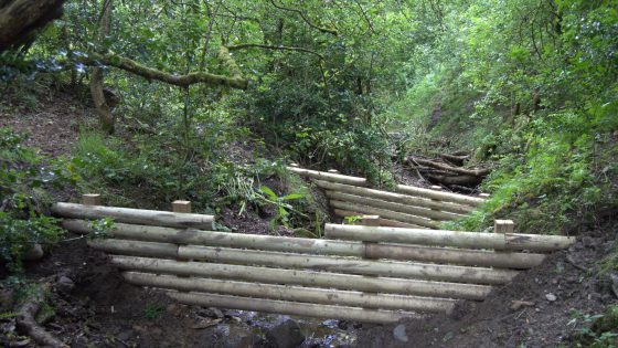
    National Trust and United Utilities are installing a series of timber “leaky dams” on moorland and farmland above the Stubbins Estate in Lancashire in a two‑year natural flood management programme to slow runoff into the River Irwell. The structures are designed to back up high flows in small headwater channels while allowing baseflow to pass, temporarily storing stormwater on the floodplain and in upstream depressions. For civil and drainage engineers, the scheme signals continued deployment of low‑cost, nature‑based attenuation measures alongside conventional hard‑engineered defences in upland catchments.

    Technical Brief

    • Safety management must address working in steep, wet channels with rapidly changing flow conditions during storms.
    • Asset owners will need inspection and maintenance regimes for timber decay, blockage, and post‑storm damage.

    Our Take

    In our database, United Utilities’ recent £30M retrofit of sustainable drainage in Liverpool and the £6M stormwater tank in St Helens show the utility pairing hard infrastructure with nature‑based measures like the Stubbins Estate leaky dams to manage peak flows across the North West catchments.

    The two‑year natural flood management programme at the River Irwell aligns with United Utilities’ wider landscape‑scale work restoring peatlands and woodlands across its North West estate, suggesting the company is treating upstream land management as a core flood and water‑quality control tool rather than a peripheral CSR activity.

    Geotechnical Software for Modern Teams

    Centralise site data, logs, and lab results with GEODB-io, CMRR-io, and HYDROGEO-io.

    No credit card required.

    • Save and export unlimited calculations
    • Advanced data visualisation
    • Generate professional PDF reports
    • Cloud storage for all your projects

    Prepared by collating external sources, AI-assisted tools, and Geomechanics.io’s proprietary mining database, then reviewed for technical accuracy & edited by our geotechnical team.

    Related Articles

    Construction worker fatalities 2025/26: HSE data and risk lessons for site engineers
    Hazards
    2 days ago

    Construction worker fatalities 2025/26: HSE data and risk lessons for site engineers

    Construction recorded the highest number of worker fatalities in Britain in 2025/26, according to new Health and Safety Executive (HSE) figures on work-related deaths. Although absolute numbers are not yet broken down publicly by sub-sector, the data place construction ahead of manufacturing, agriculture and waste, continuing a long-term pattern of disproportionate risk. The figures will sharpen scrutiny of temporary works design, work-at-height controls and plant–people interface management on sites, particularly for SMEs and subcontractor-heavy projects.

    Melbourne sinkhole investigations: geotechnical lessons for tunnel project teams
    Hazards
    6 months ago

    Melbourne sinkhole investigations: geotechnical lessons for tunnel project teams

    A sinkhole roughly 8–10 m wide and several metres deep has opened on the AJ Burkitt Reserve sporting oval in Heidelberg, directly adjacent to the North East Link tunnel alignment in Melbourne’s northeast. Victorian Infrastructure Delivery Authority has confirmed the “surface hole” is in the vicinity of active tunnelling operations, leading to a work pause while engineers and emergency crews carry out geotechnical investigations and monitoring. No injuries or structural damage have been reported, but the area remains fully cordoned off pending cause determination and stability assessment.

    Landslide and liquefaction mapping after major quakes: priorities for geotechnical teams
    Hazards
    3 days ago

    Landslide and liquefaction mapping after major quakes: priorities for geotechnical teams

    Recent major earthquakes in Venezuela and the southern Philippines have exposed how delayed mapping of landslides and liquefaction can mask the worst damage for days, especially in remote mountain valleys and low-lying coastal plains. Geoscientists are pushing for rapid post-event zonation using satellite interferometry, UAV photogrammetry and pre-existing susceptibility maps to identify blocked river valleys, buried roads and lateral spreading along reclaimed or alluvial ground. For geotechnical teams, this means integrating near-real-time remote sensing with ground reconnaissance to prioritise slope stabilisation, bridge access and lifeline corridor repairs.

    Related Industries & Products

    Construction

    Quality control software for construction companies with material testing, batch tracking, and compliance management.

    Mining

    Geotechnical software solutions for mining operations including CMRR analysis, hydrogeological testing, and data management.

    QCDB-io

    Comprehensive quality control database for manufacturing, tunnelling, and civil construction with UCS testing, PSD analysis, and grout mix design management.

    AllGeotechnicalMiningInfrastructureMaterialsHazardsEnvironmentalSoftwarePolicy