Geomechanics.io

  • Free Tools
Sign UpLog In

Geomechanics.io

Geomechanics, Streamlined.

© 2026 Geomechanics.io. All rights reserved.

Geomechanics.io

CMRR-ioGEODB-ioHYDROGEO-ioQCDB-ioFree Tools & CalculatorsBlogLatest Industry News

Industries

MiningConstructionTunnelling

Company

Terms of UsePrivacy PolicyLinkedIn
    Product
    Safety
    Projects

    Fluke SmartTrace cable spotter: reducing UK utility strike risk for project teams

    April 29, 2026|

    Reviewed by Tom Sullivan

    Fluke SmartTrace cable spotter: reducing UK utility strike risk for project teams

    First reported on The Construction Index

    30 Second Briefing

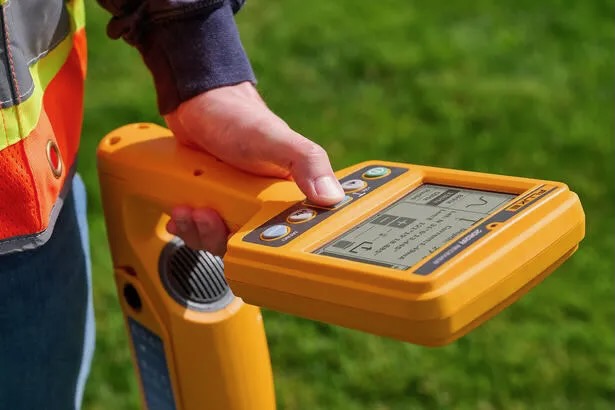
    Fluke has launched the SmartTrace 2082 Series underground locator, which injects signals to trace metallic cables and pipelines down to 6 m depth while identifying ground faults, sheath faults and coating defects where conductors contact earth. The locator connects via Bluetooth to Fluke’s PointMan app, enabling real-time geolocation, mapping and documentation of buried utilities directly on a smartphone for future works planning. Fluke cites around 60,000 utility strikes per year in UK excavations, positioning SmartTrace as a tool to cut strike risk and improve pre-dig surveys.

    Technical Brief

    • SmartTrace 2082 locates underground metallic utilities by actively injecting a tracing signal into the asset.
    • Locator output distinguishes ground faults, sheath faults and coating defects where leakage currents reach surrounding soil.
    • Fault pinpointing supports targeted excavation around damaged joints or corrosion sites, reducing open trench length.
    • Bluetooth link to Fluke’s PointMan app enables in-field as-built capture without separate survey kit.
    • Real-time mapping on smartphones allows immediate update of utility records during pre-dig surveys and trial holes.
    • Digital records from PointMan can be reused on subsequent projects, reducing repeat locating and exposure hours.
    • Fluke positions SmartTrace as part of “digital utility management”, integrating locating, verification and documentation workflows.

    Our Take

    Safety-tagged Product pieces in our database increasingly target integration with digital mapping tools for Projects, so pairing a cable spotter with platforms like PointMan suggests contractors in the United Kingdom are being pushed toward more rigorous as-built capture and clash-avoidance workflows.

    Geotechnical Software for Modern Teams

    Centralise site data, logs, and lab results with GEODB-io, CMRR-io, and HYDROGEO-io.

    No credit card required.

    • Save and export unlimited calculations
    • Advanced data visualisation
    • Generate professional PDF reports
    • Cloud storage for all your projects

    Prepared by collating external sources, AI-assisted tools, and Geomechanics.io’s proprietary mining database, then reviewed for technical accuracy & edited by our geotechnical team.

    Related Articles

    AASB S2 climate reporting: Envago implementation notes for mine operators
    Software
    9 days ago

    AASB S2 climate reporting: Envago implementation notes for mine operators

    Greenbase’s Envago platform is being deployed to help mining companies comply with Australia’s new mandatory climate reporting regime under AASB S2, which requires disclosure of climate-related risks, Scope 1–3 emissions and governance alongside financial statements. Envago replaces spreadsheet-based workflows by integrating data from site operations, energy meters and procurement systems into a single emissions and ESG reporting environment. For mine operators, this means earlier alignment with AASB S2 assurance expectations and reduced manual reconciliation effort across multiple assets and joint ventures.

    Micromine 2026 release: integrated workflows and data notes for mine engineers
    Software
    10 days ago

    Micromine 2026 release: integrated workflows and data notes for mine engineers

    Micromine has launched its 2026 Half-Year Release, rolling out upgrades across all eight products in its geology, mine design, scheduling, fleet management and processing software suite as part of a Weir-backed push for a connected mining ecosystem. The release tightens integration between exploration tools such as Micromine Origin and mine planning modules like Micromine Beyond, and links them more directly with operational platforms including Micromine Pitram. For engineers, the move signals more consistent data models and workflows from resource modelling through short-interval control and plant performance monitoring.

    Viridien Evergreen Data Solution: subsurface data workflows explained for mine planners
    Software
    11 days ago

    Viridien Evergreen Data Solution: subsurface data workflows explained for mine planners

    Viridien has launched Evergreen Data Solution, an AI‑powered subsurface data platform that automates transformation of large, complex geoscience datasets so asset teams can access and trust results more quickly. Built on Viridien’s existing digital transformation stack, it applies data science workflows to seismic, geological and petrophysical data, targeting shorter interpretation cycle times from exploration through development planning. For mine planners and resource geologists, the tool aims to tighten model update loops, standardise multi‑source inputs and reduce manual data conditioning effort.

    Related Industries & Products

    Mining

    Geotechnical software solutions for mining operations including CMRR analysis, hydrogeological testing, and data management.

    Tunnelling

    Specialised solutions for tunnelling projects including grout mix design, hydrogeological analysis, and quality control.

    CMRR-io

    Streamline coal mine roof stability assessments with our cloud-based CMRR software featuring automated calculations, multi-scenario analysis, and collaborative workflows.

    HYDROGEO-io

    Comprehensive hydrogeological testing platform for managing, analysing, and reporting on packer tests, lugeon values, and hydraulic conductivity assessments.

    GEODB-io

    Centralised geotechnical data management solution for storing, accessing, and analysing all your site investigation and material testing data.

    AllGeotechnicalMiningInfrastructureMaterialsHazardsEnvironmentalSoftwarePolicy