Geomechanics.io

  • Free Tools
Sign UpLog In

Geomechanics.io

Geomechanics, Streamlined.

© 2026 Geomechanics.io. All rights reserved.

Geomechanics.io

CMRR-ioGEODB-ioHYDROGEO-ioQCDB-ioFree Tools & CalculatorsBlogLatest Industry News

Industries

MiningConstructionTunnelling

Company

Terms of UsePrivacy PolicyLinkedIn
    Failure
    Safety
    Projects

    Dorking–Horsham landslip: geotechnical failure lessons for rail engineers

    January 28, 2026|

    Reviewed by Joe Ashwell

    Dorking–Horsham landslip: geotechnical failure lessons for rail engineers

    First reported on New Civil Engineer

    30 Second Briefing

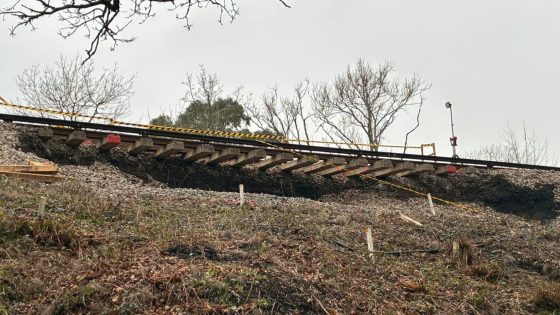
    A landslip south of Ockley station in Surrey has stripped away the embankment supporting one of the two Horsham–Dorking tracks, leaving the rail and sleepers cantilevered in mid‑air and forcing full closure of the route until at least mid‑February. Network Rail engineers now face emergency stabilisation of the failed cutting or embankment, reconstruction of the formation, and re‑ballasting before traffic can resume. The incident will focus attention on drainage, slope monitoring and resilience of Victorian earthworks under increasingly intense winter rainfall.

    Technical Brief

    • Embankment failure appears as a near-vertical scarp with ballast and subgrade completely removed beneath one rail.
    • Failure mechanism likely shallow rotational or translational slip in oversteepened, waterlogged fill or cutting.
    • Investigation will rely on rapid visual inspection, geomorphological mapping, and targeted boreholes or dynamic probing along the slip.
    • Remote condition assessment using LiDAR, photogrammetry and track-mounted geometry cars will define deformation extent and residual capacity.
    • Short-term remediation options include sheet piles, king post walls or soil nails with sprayed concrete facing to re-support the cess.
    • Continuous monitoring with automated total stations, tilt sensors and piezometers would typically be deployed during and after reinstatement.
    • Safety protocols require full line block, exclusion zones at the scarp, and strict plant access control under relevant rail standards.
    • Similar earthwork failures are driving route-wide resilience programmes, prioritising high-risk cuttings and embankments for drainage upgrades.

    Our Take

    Among the 36 Hazards stories in our coverage, UK rail earthwork failures like this Ockley–Surrey landslip are relatively infrequent compared with flood and tunnel incidents, suggesting slope management on secondary routes may now attract closer scrutiny from asset owners.

    The extended route closure ‘until at least mid‑February’ implies a significant loss of track support, which typically triggers full geotechnical re‑design rather than simple reinstatement, with knock‑on implications for similar cuttings on the Dorking–Horsham corridor.

    With this tagged under both Failure and Projects, it is likely to be treated as a capital intervention rather than routine maintenance, meaning designers may push for more conservative earthwork geometries and drainage upgrades on comparable Victorian-era embankments in the United Kingdom network.

    Geotechnical Software for Modern Teams

    Centralise site data, logs, and lab results with GEODB-io, CMRR-io, and HYDROGEO-io.

    No credit card required.

    • Save and export unlimited calculations
    • Advanced data visualisation
    • Generate professional PDF reports
    • Cloud storage for all your projects

    Prepared by collating external sources, AI-assisted tools, and Geomechanics.io’s proprietary mining database, then reviewed for technical accuracy & edited by our geotechnical team.

    Related Articles

    Melbourne sinkhole investigations: geotechnical lessons for tunnel project teams
    Hazards
    in about 1 month

    Melbourne sinkhole investigations: geotechnical lessons for tunnel project teams

    A sinkhole roughly 8–10 m wide and several metres deep has opened on the AJ Burkitt Reserve sporting oval in Heidelberg, directly adjacent to the North East Link tunnel alignment in Melbourne’s northeast. Victorian Infrastructure Delivery Authority has confirmed the “surface hole” is in the vicinity of active tunnelling operations, leading to a work pause while engineers and emergency crews carry out geotechnical investigations and monitoring. No injuries or structural damage have been reported, but the area remains fully cordoned off pending cause determination and stability assessment.

    Nepal’s Himalayan settlements: flood and landslide risk lens for engineers
    Hazards
    3 days ago

    Nepal’s Himalayan settlements: flood and landslide risk lens for engineers

    Escalating extreme rainfall and glacial melt are driving more frequent floods and landslides in Nepal’s Himalayan districts, with Karnali Province’s steep, highly fractured slopes and narrow river valleys particularly exposed. Recent events include debris flows cutting off road access to remote settlements and riverbank erosion undermining gabion walls and informal river training works along the Karnali and Bheri rivers. Engineers are being pushed towards slope stabilisation with bioengineering, improved drainage, and relocation or elevation of critical infrastructure away from active channels and unstable colluvium.

    CCC and ICE climate adaptation warning: design priorities for UK engineers
    Hazards
    4 days ago

    CCC and ICE climate adaptation warning: design priorities for UK engineers

    The Climate Change Committee warns that the “British way of life” faces escalating risk from heat, flooding and drought, with the Institution of Civil Engineers backing calls for rapid, large‑scale adaptation of UK infrastructure. Priority actions flagged include upgrading urban drainage and flood defences for more intense cloudbursts, retrofitting buildings for sustained 40°C heat, and securing water supply resilience against multi‑year droughts. For civil and geotechnical engineers, this signals imminent pressure to redesign assets for higher hydraulic loads, thermal stresses and soil moisture variability within the next planning cycle.

    Related Industries & Products

    Construction

    Quality control software for construction companies with material testing, batch tracking, and compliance management.

    Mining

    Geotechnical software solutions for mining operations including CMRR analysis, hydrogeological testing, and data management.

    QCDB-io

    Comprehensive quality control database for manufacturing, tunnelling, and civil construction with UCS testing, PSD analysis, and grout mix design management.

    AllGeotechnicalInfrastructureHazardsEnvironmental