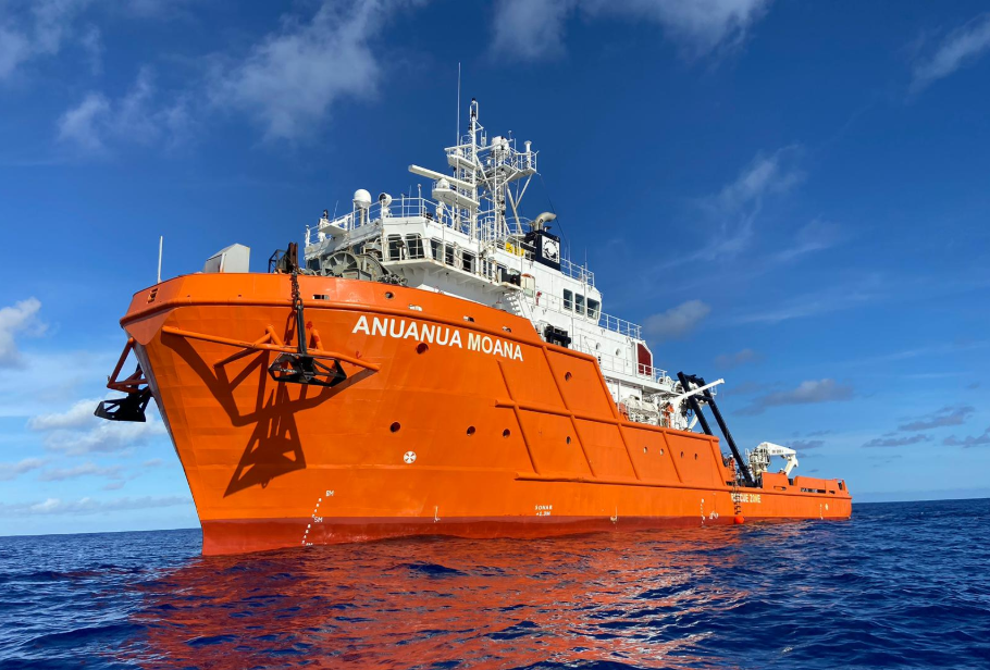
American Ocean Minerals vessel Anuanua Moana: design and survey notes for engineers
Reviewed by Tom Sullivan
First reported on MINING.com
30 Second Briefing
American Ocean Minerals has deployed its 196‑foot research vessel Anuanua Moana as a dedicated deep-sea exploration and environmental monitoring platform across more than 500,000 km² of Cook Islands EEZ and US‑regulated areas, including AOM Area 1 in the Clarion‑Clipperton Zone and AOM Area 2 in the Penrhyn Basin. The ship carries advanced sonar, subsea tracking, a 6,000‑metre‑rated ROV, and onboard geology, chemistry and biology labs, and has already mapped a 23,500 km² licence in 16 days, supporting estimates exceeding 500 million wet tonnes of polymetallic nodules. Backed by a merger with Odyssey Marine Exploration to form a roughly $1 billion US‑controlled critical minerals company, AOMC has secured compliance for two Deep Seabed Hard Mineral Resources Act applications covering 1.4 billion tonnes of inferred resources, while collecting over three years of baseline ecological data for EIAs and feasibility studies amid strong environmental scrutiny.
Technical Brief
- Anuanua Moana’s 2007-built, 196‑foot hull has been retrofitted as a dedicated offshore geoscience platform.
- Single‑platform integration of sonar, subsea tracking, ROV and labs reduces mobilisation/demobilisation downtime between campaigns.
- Onboard geology, chemistry and biology laboratories enable immediate core, nodule and water‑column analysis at sea.
- AOMC has secured compliance for two US Deep Seabed Hard Mineral Resources Act exploration applications.
- Those US‑regulated applications collectively cover more than 1.4 billion tonnes of inferred seabed resources.
- Exploration portfolio spans Cook Islands EEZ licences (Moana Minerals EL3, CIC Limited) plus US‑regulated high‑seas areas.
- AOMC reports more than three years of baseline ecological monitoring to underpin EIAs and feasibility studies.
- Merger with Odyssey Marine Exploration targets a US‑controlled deep‑sea critical minerals entity valued near US$1 billion.
Our Take
The deployment of Anuanua Moana strengthens American Ocean Minerals’ position ahead of its planned all‑stock reverse takeover with Odyssey Marine Exploration to form a roughly US$1 billion Nasdaq‑listed deep‑sea miner, signalling to investors that the merged AOMC vehicle will control both assets and in‑house survey capability in the Clarion‑Clipperton Zone and Cook Islands’ EEZ.
In our database, only a handful of Mining pieces combine ‘Projects’ and ‘Sustainability’ tags with deep‑sea polymetallic nodules for cobalt and copper, so the Atlas project and AOM Area 1/2 work stand out as one of the more advanced attempts to pair multi‑year baseline ecology data with commercial‑scale resource definition in US‑regulated international waters.
The inferred 1.4 billion tonnes of nodules tied to AOM’s DSHMRA applications, together with the 500 million wet tonnes estimate supported by this vessel, put the Clarion‑Clipperton Zone and Cook Islands’ EEZ workstreams into the same strategic league as other large‑scale critical minerals plays in our coverage, potentially giving AOM leverage when competing with TMC and other CCZ‑focused developers for offtake and strategic partners.
Prepared by collating external sources, AI-assisted tools, and Geomechanics.io’s proprietary mining database, then reviewed for technical accuracy & edited by our geotechnical team.
Related Articles

Related Industries & Products
Mining
Geotechnical software solutions for mining operations including CMRR analysis, hydrogeological testing, and data management.
CMRR-io
Streamline coal mine roof stability assessments with our cloud-based CMRR software featuring automated calculations, multi-scenario analysis, and collaborative workflows.
HYDROGEO-io
Comprehensive hydrogeological testing platform for managing, analysing, and reporting on packer tests, lugeon values, and hydraulic conductivity assessments.
GEODB-io
Centralised geotechnical data management solution for storing, accessing, and analysing all your site investigation and material testing data.