Geomechanics.io

  • Free Tools
Sign UpLog In

Geomechanics.io

Geomechanics, Simplified.

© 2025 Geomechanics.io. All rights reserved.

Geomechanics.io

CMRR-ioGEODB-ioHYDROGEO-ioQCDB-ioFree Tools & CalculatorsBlogLatest Industry News

Industries

MiningConstructionTunnelling

Company

Terms of UsePrivacy PolicyLinkedIn
    Product
    Projects

    Dalux SiteWalk and European BIM leadership: practical lessons for project teams

    December 16, 2025|

    Reviewed by Joe Ashwell

    Dalux SiteWalk and European BIM leadership: practical lessons for project teams

    First reported on The Construction Index

    30 Second Briefing

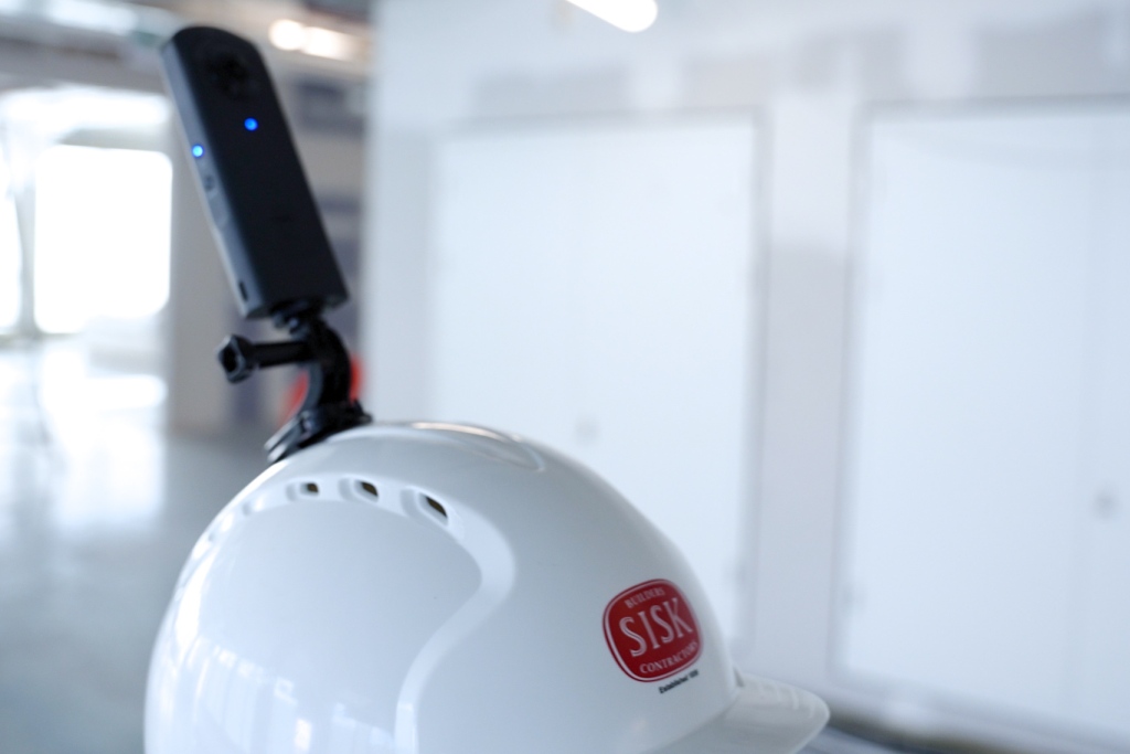
    Dalux claims European BIM leadership after a decade of 40%+ annual growth, with its platform now on 7,800 UK projects, 1.7 million active accounts across Europe and 2024 revenues of about US $100m, all achieved debt-free and without external investment. Its SiteWalk tool in Dalux Field uses helmet-mounted 360° cameras to map images directly onto BIM models, enabling weekly visual progress tracking, integrated quality checklists and ITPs, and remote verification of works on projects such as Great Ormond Street Hospital. Usage has tripled in a year to over one million 360° images captured monthly across 38 countries, with contractors like Sisk reporting reduced reliance on third-party survey providers and wider rollout to smaller sites.

    Technical Brief

    • SiteWalk uses helmet-mounted 360° cameras, with images auto-registered onto the federated BIM model in Dalux Field.
    • Visual records are captured along walking routes, enabling corridor-by-corridor comparison of planned versus as-built conditions.
    • Reality capture is embedded into structured workflows for safety management, approvals, quality inspections and hold points.
    • Integrated checklists and inspection and test plans (ITPs) are linked directly to the 360° imagery for evidence-based sign-off.
    • Reduced reliance on third-party survey or capture providers shifts cost and programme control back to main contractors.

    Our Take

    Within our several Software stories, Dalux is one of the few with a footprint spanning 38 countries and 55 offices, signalling that construction-focused BIM tools are starting to reach the same geographic scale as mainstream enterprise SaaS rather than remaining niche project add‑ons.

    The reported 40%+ annual growth rate to around US$100 million revenue suggests Dalux is approaching the size where UK and EU contractors such as Sisk, Willmott Dixon and Wates may start rationalising overlapping point solutions (e.g. separate 360° capture or progress-tracking tools) in favour of a single platform to simplify data governance.

    Tripling SiteWalk usage and capturing over a million 360° images per month across Europe and the Nordics implies that site-based QA, claims evidence and as‑built verification workflows are rapidly becoming data-heavy; contractors in the UK, Ireland and Germany will need more robust storage, bandwidth and model-management practices than traditional document control systems provide.

    Geotechnical Software for Modern Teams

    Centralise site data, logs, and lab results with GEODB-io, CMRR-io, and HYDROGEO-io.

    No credit card required.

    • Save and export unlimited calculations
    • Advanced data visualisation
    • Generate professional PDF reports
    • Cloud storage for all your projects

    Prepared by collating external sources, AI-assisted tools, and Geomechanics.io’s proprietary mining database, then reviewed for technical accuracy & edited by our geotechnical team.

    Related Articles

    ALLMI Proximity to Slopes tool: stability planning notes for crane engineers
    Software
    about 13 hours ago

    ALLMI Proximity to Slopes tool: stability planning notes for crane engineers

    Proximity to Slopes, a new calculator in the Association of Lorry Loader Manufacturers & Importers (ALLMI) app, now quantifies safe stabiliser leg positions for loader cranes working beside embankments. Users input mat width, horizontal distance from the crane base to the crest, and slope height; the tool then defines a “danger area” where stabilisers must not be placed to avoid loss of stability. For temporary works and lift planners, this offers a quick, standardised check when siting cranes on or near cuttings, bunds and roadside batters.

    From big ideas to delivery: immersive digital twins for project teams
    Software
    2 days ago

    From big ideas to delivery: immersive digital twins for project teams

    Infrastructure designers are increasingly turning to immersive digital twins and extended reality (XR) to close the gap between CAD abstractions and real-world performance, moving beyond static 2D and 3D screens. By integrating live sensor data, construction sequencing and asset operation scenarios into interactive models, project teams can virtually walk through stations, tunnels or bridges, test maintainability clearances and rehearse complex lifts before site work. This shift demands new workflows, with geotechnical, structural and M&E inputs federated in real time rather than exchanged as periodic drawing sets.

    GBM Konect in Bendigo: integrated road asset data and planning lessons for engineers
    Software
    10 days ago

    GBM Konect in Bendigo: integrated road asset data and planning lessons for engineers

    Road maintenance planning in the City of Bendigo has been overhauled using GBM Konect integrated directly with the council’s asset management system, linking live field data from graders, patching trucks and concreting crews to central asset records. Crews now capture condition data, photos and completed works on mobile devices in real time, feeding GIS-based maps that prioritise pavement interventions and reduce duplicated site visits. For contractors and councils, the approach shows how tighter integration between field data capture and asset registers can sharpen programming of resurfacing and rehabilitation works.

    Related Industries & Products

    Construction

    Quality control software for construction companies with material testing, batch tracking, and compliance management.

    Mining

    Geotechnical software solutions for mining operations including CMRR analysis, hydrogeological testing, and data management.

    QCDB-io

    Comprehensive quality control database for manufacturing, tunnelling, and civil construction with UCS testing, PSD analysis, and grout mix design management.

    AllGeotechnicalMiningInfrastructureMaterialsHazardsEnvironmentalSoftwarePolicy