Bentley expands asset analytics: drone, AI and digital twin takeaways for engineers
Reviewed by Tom Sullivan
First reported on The Construction Index
30 Second Briefing
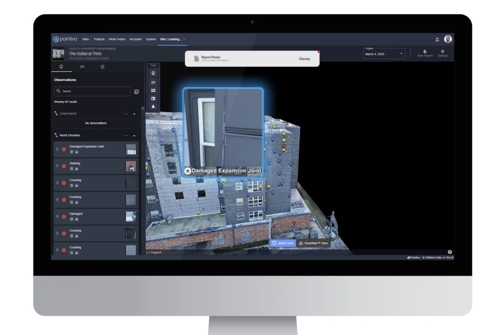
Bentley Systems has acquired Talon Aerolytics and the drone-data and AI assets of Pointivo Technology to expand its Bentley Asset Analytics portfolio, which already includes OpenTower iQ for telecom towers and Blyncsy for road networks. Talon brings an inspection and asset digitisation platform used across wireless telecom, broadband and electric utilities, combining workflow automation, digital twins and AI for recurring tower and line inspections. Pointivo adds patented AI-driven inventory and damage detection, advanced point-cloud processing, automated measurement and geolocated drone capture, aimed at continuous condition assessment for 5G roll-outs and grid modernisation.
Technical Brief
- Both Talon and Pointivo deals closed in December, allowing immediate integration into Bentley’s stack.
- Talon’s platform is already configured for recurring tower and line inspections rather than one‑off survey campaigns.
- Workflow automation in Talon is geared to full asset lifecycle management, not just inspection scheduling.
- Integration with Bentley’s engineering simulation tools enables condition‑to‑performance linkage, e.g. defect → structural response.
- Pointivo’s contribution includes patented AI for inventory and damage detection from large unstructured visual datasets.
- Its toolchain covers advanced point‑cloud processing, automated dimensional measurement and asset condition classification from drone capture.
- High‑fidelity, geolocated drone imagery from Pointivo is optimised for continuous, repeatable condition assessment baselines.
- Bentley reports Talon has a pipeline of enterprise‑wide contracts and profitable growth, de‑risking adoption for large owners.
- Continuous inspection workflows are explicitly targeted at improving maintenance economics and uptime for critical linear and vertical infrastructure.
Our Take
Within the 13 Software stories in our database, Bentley Systems is one of the few infrastructure-focused vendors using M&A to fold specialist analytics (such as Talon Aerolytics and Pointivo) directly into a unified asset platform rather than relying on loose integrations.
Positioning Bentley Asset Analytics and OpenTower iQ out of the United Kingdom gives Bentley Systems a stronger base in a market where transport and utilities owners are already piloting AI-based inspection tools, which can accelerate adoption versus regions with more fragmented asset standards.
For mining and civil operators, the consolidation of Talon and Blyncsy under Bentley Systems suggests future project workflows where drone, roadside and structural condition data are managed in a single environment, reducing the current reliance on bespoke point solutions for each asset class.
Prepared by collating external sources, AI-assisted tools, and Geomechanics.io’s proprietary mining database, then reviewed for technical accuracy & edited by our geotechnical team.
Related Articles


Related Industries & Products
Mining
Geotechnical software solutions for mining operations including CMRR analysis, hydrogeological testing, and data management.
Construction
Quality control software for construction companies with material testing, batch tracking, and compliance management.
CMRR-io
Streamline coal mine roof stability assessments with our cloud-based CMRR software featuring automated calculations, multi-scenario analysis, and collaborative workflows.
HYDROGEO-io
Comprehensive hydrogeological testing platform for managing, analysing, and reporting on packer tests, lugeon values, and hydraulic conductivity assessments.
GEODB-io
Centralised geotechnical data management solution for storing, accessing, and analysing all your site investigation and material testing data.