Geomechanics.io

  • Free Tools
Sign UpLog In

Geomechanics.io

Geomechanics, Streamlined.

© 2026 Geomechanics.io. All rights reserved.

Geomechanics.io

CMRR-ioGEODB-ioHYDROGEO-ioQCDB-ioFree Tools & CalculatorsBlogLatest Industry News

Industries

MiningConstructionTunnelling

Company

Terms of UsePrivacy PolicyLinkedIn
    AllGeotechnicalMiningInfrastructureMaterialsHazardsEnvironmentalSoftwarePolicy
    Standard/Guideline
    Projects
    Sustainability

    Infrastructure Unit and faster consents: key implications for UK project engineers

    March 13, 2026|

    Reviewed by Tom Sullivan

    Infrastructure Unit and faster consents: key implications for UK project engineers

    First reported on New Civil Engineer

    30 Second Briefing

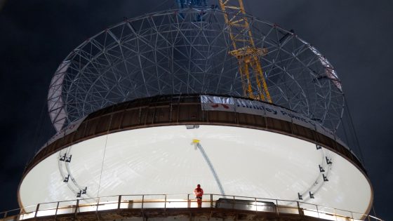
    The UK Government has announced changes to the way the Environment Agency and Natural England handle planning casework, aiming to speed up consents for major housing and infrastructure schemes. A new central Infrastructure Unit will triage and coordinate environmental assessments on nationally significant projects, with standardised templates and earlier engagement intended to cut repeated requests for information. For civil and geotechnical teams, the shift could compress timelines for flood risk, groundwater, habitat and nutrient neutrality assessments, increasing pressure on front‑loaded site investigation and design.

    Technical Brief

    • Government intends to publish clearer service standards for statutory consultee response periods on major schemes.

    Our Take

    Within our 141 Policy stories, the United Kingdom features frequently where consent regimes intersect with infrastructure delivery, so a UK Government-backed Infrastructure Unit will likely be watched as a template by other jurisdictions looking to de-risk major project timelines.

    Because this piece sits at the intersection of the 'Standard/Guideline', 'Projects' and 'Sustainability' tags in our database, it signals that environmental assessment reform is now being framed less as pure regulation and more as a delivery tool for capital projects, especially for transport and energy schemes.

    For UK-based project promoters, a central Infrastructure Unit tied into environmental checks could shift the critical path from local planning bottlenecks to earlier, portfolio-level screening, which in practice may favour well-resourced sponsors who can standardise documentation across multiple schemes.

    Geotechnical Software for Modern Teams

    Centralise site data, logs, and lab results with GEODB-io, CMRR-io, and HYDROGEO-io.

    No credit card required.

    • Save and export unlimited calculations
    • Advanced data visualisation
    • Generate professional PDF reports
    • Cloud storage for all your projects

    Prepared by collating external sources, AI-assisted tools, and Geomechanics.io’s proprietary mining database, then reviewed for technical accuracy & edited by our geotechnical team.

    Related Articles

    Fast-tracking US critical minerals: Oxfam safeguards lens for project teams
    Policy
    about 9 hours ago

    Fast-tracking US critical minerals: Oxfam safeguards lens for project teams

    Fast-tracking US critical minerals projects under President Trump’s March 2025 executive order has seen some mining permits issued in as little as 20 days, prompting Oxfam America to warn that compressed timelines without robust environmental review and community consultation could trigger force majeure events, legal challenges and multimillion-dollar delays. Oxfam policy leads Emily Greenspan and Andrew Bogrand argue that IFC performance standards should be treated as a minimum and that US-backed export credit and development finance should be tied to IRMA’s more stringent audit regime. They also caution that the industry-led Consolidated Mining Standard Initiative could dilute existing benchmarks and that policymakers still underestimate the globalised nature of refining and processing, particularly in regions such as Africa’s Copperbelt.

    Scottish nuclear feasibility study delay: siting implications for project teams
    Policy
    about 17 hours ago

    Scottish nuclear feasibility study delay: siting implications for project teams

    A UK Government-commissioned feasibility assessment on building new nuclear power plants at existing Scottish nuclear sites is now unlikely to be released before the Scottish Parliament elections on 7 May. The study is expected to focus on brownfield nuclear locations such as Hunterston and Torness, assessing grid connection capacity, cooling water availability and regulatory constraints under Scotland’s current anti-nuclear policy. The delay leaves developers and consultants without key data on potential reactor siting, licensing timelines and supporting civil works for any future large-scale or SMR projects.

    Mandatory BNG for NSIPs delayed: design and metric implications for project teams
    Policy
    about 18 hours ago

    Mandatory BNG for NSIPs delayed: design and metric implications for project teams

    Mandatory biodiversity net gain (BNG) for nationally significant infrastructure projects (NSIPs) has been pushed back to November 2026, a six‑month delay from the original May 2026 start. The deferral affects DCO‑consented schemes such as major highways, rail corridors and large energy projects, which will ultimately need to evidence at least 10% biodiversity uplift using habitat units and metric‑based baselines. Designers and environmental consultants gain extra time to refine baseline surveys, habitat creation plans and long‑term management obligations before BNG becomes a legal requirement.

    Related Industries & Products

    Construction

    Quality control software for construction companies with material testing, batch tracking, and compliance management.

    Mining

    Geotechnical software solutions for mining operations including CMRR analysis, hydrogeological testing, and data management.

    HYDROGEO-io

    Comprehensive hydrogeological testing platform for managing, analysing, and reporting on packer tests, lugeon values, and hydraulic conductivity assessments.

    GEODB-io

    Centralised geotechnical data management solution for storing, accessing, and analysing all your site investigation and material testing data.