Geomechanics.io

  • Free Tools
Sign UpLog In

Geomechanics.io

Geomechanics, Streamlined.

© 2026 Geomechanics.io. All rights reserved.

Geomechanics.io

CMRR-ioGEODB-ioHYDROGEO-ioQCDB-ioFree Tools & CalculatorsBlogLatest Industry News

Industries

MiningConstructionTunnelling

Company

Terms of UsePrivacy PolicyLinkedIn
    Projects

    Fermi Exploration’s Perch River uranium project: ExoSphere survey insights for drill design

    January 22, 2026|

    Reviewed by Joe Ashwell

    Fermi Exploration’s Perch River uranium project: ExoSphere survey insights for drill design

    First reported on International Mining – News

    30 Second Briefing

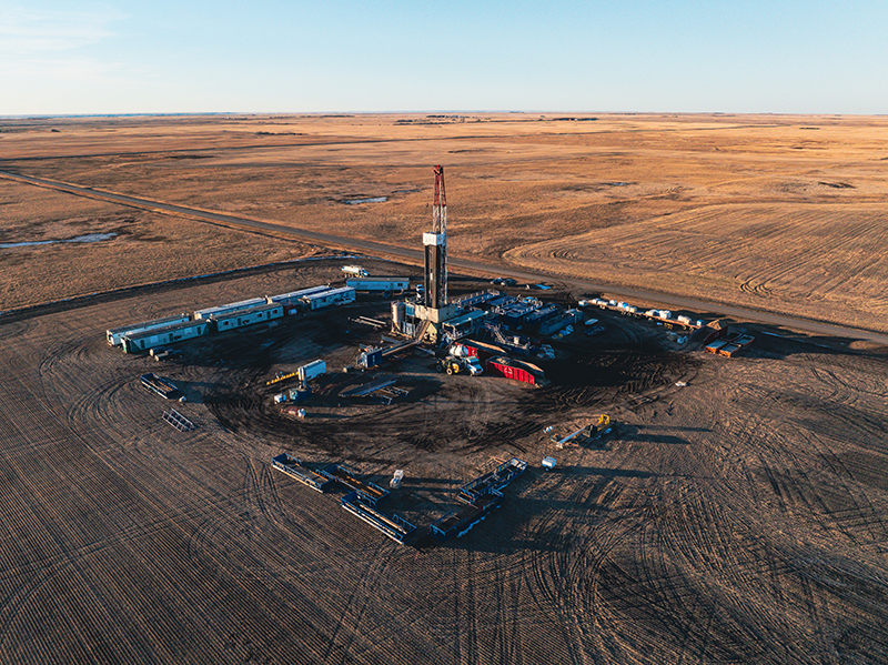
    Deployment of Fleet Space Technologies’ ExoSphere ambient noise tomography platform at Fermi Exploration’s Perch River uranium project in Saskatchewan’s Athabasca Basin is refining subsurface imaging and defining a new high-priority exploration corridor. Satellite-connected geophones are generating 3D velocity models to map structure beneath cover, allowing Fermi to tighten drill targeting and reduce reliance on wide-spaced reconnaissance holes. For geologists and geophysicists, the work signals broader use of rapid passive seismic surveys to de-risk early-stage basement-hosted uranium exploration in deeply covered terrains.

    Technical Brief

    • Integration with existing geophysics and geology at Perch River is refining structural interpretations at depth.

    Our Take

    Uranium items in our database are relatively few compared with gold and battery metals, so Fermi Exploration’s work at Perch River in Saskatchewan stands out as part of a smaller cluster of Athabasca Basin coverage where exploration-stage decisions can materially shift project pipelines.

    For Athabasca Basin uranium, early-stage geophysical targeting like Fleet Space’s ExoSphere at Perch River is strategically important because deep, structurally controlled deposits often sit under thick cover, making conventional drilling campaigns in Canada both capital-intensive and slow to refine.

    Deploying space-enabled geophysics at a greenfield uranium project in Saskatchewan suggests juniors are looking for ways to compress targeting timelines and de-risk initial drill programmes, which can be critical for securing follow-on funding in a market where uranium stories compete with more numerous battery-metal projects in our coverage.

    Geotechnical Software for Modern Teams

    Centralise site data, logs, and lab results with GEODB-io, CMRR-io, and HYDROGEO-io.

    No credit card required.

    • Save and export unlimited calculations
    • Advanced data visualisation
    • Generate professional PDF reports
    • Cloud storage for all your projects

    Prepared by collating external sources, AI-assisted tools, and Geomechanics.io’s proprietary mining database, then reviewed for technical accuracy & edited by our geotechnical team.

    Related Articles

    Sandover ultra high-grade fluorite for Tivan: resource and flowsheet notes for planners
    Mining
    about 8 hours ago

    Sandover ultra high-grade fluorite for Tivan: resource and flowsheet notes for planners

    Ultra high-grade fluorite intercepts from Tivan Limited’s maiden drilling at the Sandover project in the Northern Territory show multiple drill holes returning exceptionally rich mineralisation, positioning the asset as a potentially significant fluorite source. The results come from the first systematic programme over the Sandover tenements, targeting structurally controlled fluorite-bearing zones identified in earlier surface work. For geologists and mine planners, the continuity and grade across several holes will drive follow-up drilling, resource definition and early thinking on beneficiation flowsheets for high-purity CaF₂ products.

    Alligator Energy’s Samphire BFS: ISR design and hydrogeology notes for engineers
    Mining
    about 9 hours ago

    Alligator Energy’s Samphire BFS: ISR design and hydrogeology notes for engineers

    Alligator Energy has started a bankable feasibility study (BFS) on its Samphire uranium project near Whyalla in South Australia, moving the in‑situ recovery (ISR) development closer to a final investment decision as uranium prices trade near 15‑year highs. The BFS will refine wellfield layouts, leach chemistry and processing flowsheets for the Blackbush and Plumbush deposits, building on previous ISR field trials and updated JORC resources. For geotechnical and hydrogeological teams, the work will focus on aquifer characterisation, permeability controls and containment of lixiviant within the target sandstone units.

    FLS Mackay hub for Bowen Basin: maintenance and downtime impacts for miners
    Mining
    about 9 hours ago

    FLS Mackay hub for Bowen Basin: maintenance and downtime impacts for miners

    FLS has opened a large-scale service centre in Mackay, central to the Bowen Basin coalfields, to cut shutdown durations for Queensland miners by bringing overhaul capability for crushers, mills and vibrating screens closer to site. The modern workshop is sized for major components such as SAG mill heads and large cone crusher shells, with overhead lifting, specialised machining and condition-monitoring support integrated under one roof. Locating this capacity in Mackay reduces freight time for heavy equipment, enabling faster turnaround on wear parts and planned maintenance campaigns.

    Related Industries & Products

    Mining

    Geotechnical software solutions for mining operations including CMRR analysis, hydrogeological testing, and data management.

    CMRR-io

    Streamline coal mine roof stability assessments with our cloud-based CMRR software featuring automated calculations, multi-scenario analysis, and collaborative workflows.

    HYDROGEO-io

    Comprehensive hydrogeological testing platform for managing, analysing, and reporting on packer tests, lugeon values, and hydraulic conductivity assessments.

    GEODB-io

    Centralised geotechnical data management solution for storing, accessing, and analysing all your site investigation and material testing data.

    AllGeotechnicalMiningInfrastructureMaterialsHazardsEnvironmentalSoftwarePolicy