BGS ‘higher confidence model’: depth-to-bedrock insights for UK ground engineers
Reviewed by Tom Sullivan
First reported on New Civil Engineer
30 Second Briefing
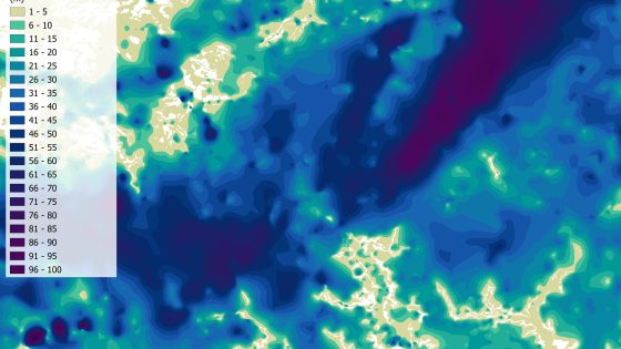
An updated “higher confidence model” from the British Geological Survey refines estimates of superficial deposit thickness above Great Britain’s bedrock, giving engineers improved depth-to-rock data for foundations, earthworks and buried infrastructure. The model integrates existing BGS geological mapping with borehole records and geophysical datasets to reduce uncertainty in areas with complex drift sequences and variable till or alluvium cover. Practitioners can use the outputs to optimise preliminary ground investigation targeting, refine early-stage design assumptions and better screen geohazard susceptibility at corridor and site scale.
Technical Brief
- BGS’s “higher confidence model” outputs a gridded national layer of superficial thickness above bedrock.
- Model development combines legacy 2D geological mapping with point borehole data and areal geophysical coverage.
- Calibration uses borehole-proven rockhead depths to constrain interpolated thickness in data-sparse zones.
- Geophysical inputs allow refinement where drift architecture is complex and borehole spacing is wide.
- Output resolution and confidence flags enable engineers to distinguish screened corridors from locations needing dense investigation.
- For design, the dataset supports early selection of founding strata and approximate excavation volumes for linear schemes.
- BGS limits the model’s use to regional and corridor-scale assessments; it does not replace site-specific GI.
Our Take
Across recent Geotechnical coverage, BGS work in Great Britain has increasingly focused on subsurface characterisation at different scales – from upper 2 m seabed mapping in the UK North Sea to catchment‑scale groundwater studies on the River Tweed – so a higher‑confidence bedrock depth model is likely to be folded into the same toolchain for early‑stage project screening.
The push by BGS to build a national geotechnical data service for UK ground investigation records suggests this new bedrock model will not just be a map but a reference layer that consultants can query alongside GI logs, improving desk‑study reliability before committing to expensive intrusive works.
Prepared by collating external sources, AI-assisted tools, and Geomechanics.io’s proprietary mining database, then reviewed for technical accuracy & edited by our geotechnical team.
Related Articles

Related Industries & Products
Mining
Geotechnical software solutions for mining operations including CMRR analysis, hydrogeological testing, and data management.
Construction
Quality control software for construction companies with material testing, batch tracking, and compliance management.
CMRR-io
Streamline coal mine roof stability assessments with our cloud-based CMRR software featuring automated calculations, multi-scenario analysis, and collaborative workflows.
HYDROGEO-io
Comprehensive hydrogeological testing platform for managing, analysing, and reporting on packer tests, lugeon values, and hydraulic conductivity assessments.
GEODB-io
Centralised geotechnical data management solution for storing, accessing, and analysing all your site investigation and material testing data.