American Ocean Minerals’ Cook Islands mission: baseline data lens for mine planners
Reviewed by Tom Sullivan
First reported on MINING.com
30 Second Briefing
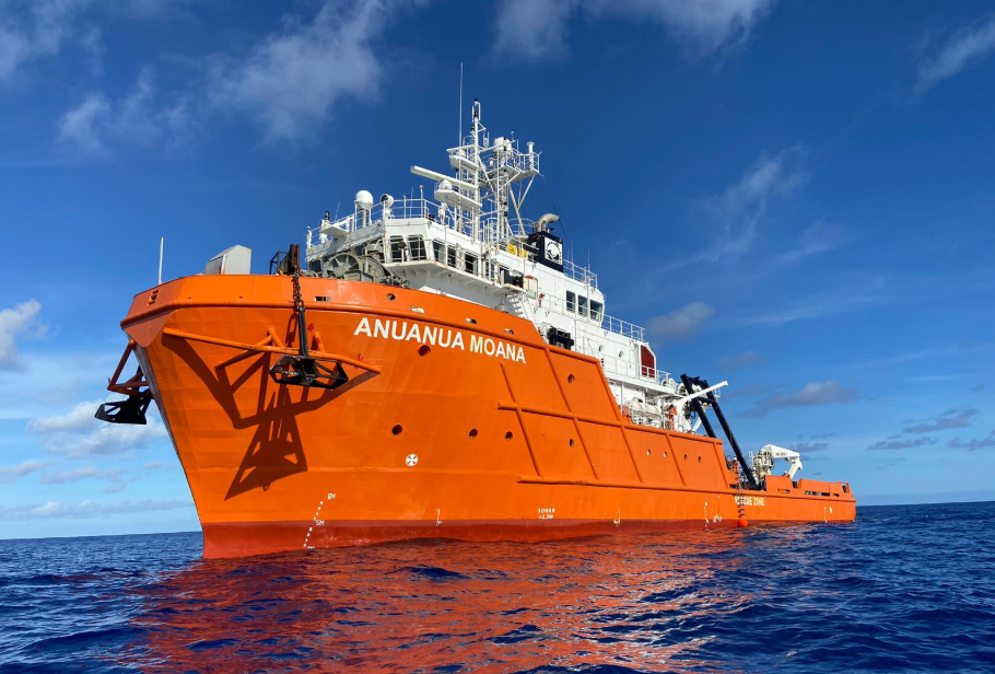
American Ocean Minerals has completed its three‑week Expedition 7 in the Cook Islands’ EEZ, using the 196‑foot research vessel Anuanua Moana to survey 53 sites and collect 60 box cores, 62 multicores and 4,059 physical samples over Moana Minerals’ EL3 polymetallic nodule licence. The campaign integrates sediment physico‑chemistry, macrofaunal and meiofaunal counts, foraminiferal studies, eDNA, bathymetry and water‑column biomass data to define baseline ecological conditions and resource variability. Results will feed directly into Moana Minerals’ Environmental Impact Statement due H1 2027 and a pre‑feasibility study targeted for H2 2026.
Technical Brief
- Anuanua Moana, a 196‑foot vessel built in 2007 and acquired in 2022, has been fully refurbished as AOMC’s central deep‑sea exploration and environmental monitoring platform.
- The vessel was deployed as a shared asset across AOMC’s portfolio, including Moana Minerals’ EL3 licence within the Cook Islands Seabed Minerals Authority regime.
- AOMC’s US‑regulated projects cover more than 1.4 billion tonnes of inferred polymetallic nodule resources under Deep Seabed Hard Mineral Resources Act exploration applications.
- Expedition 7’s integrated sampling explicitly targeted polymetallic nodule resource refinement within the Moana 1 Project Area, not just baseline ecology.
- Biological baselining combined quantitative macrofaunal, meiofaunal and foraminiferal counts with molecular eDNA, enabling taxonomic cross‑validation and detection of cryptic biodiversity.
- Physical and chemical characterisation of sediments was coupled with bathymetry, water‑column biomass and surface marine observations to resolve habitat heterogeneity at survey scale.
- Corporate strategy explicitly links recurring, in‑house vessel deployment to reduced dependence on third‑party ship availability and more consistent long‑term environmental datasets.
Our Take
The inferred 1.4 billion tonnes of polymetallic nodules linked to AOMC’s Clarion‑Clipperton Zone applications, noted in our earlier coverage of its NOAA DSHMRA filings, suggests the Cook Islands work around the Penrhyn Basin is being positioned as a parallel resource base rather than a one‑off exploration play.
Among recent critical‑minerals pieces in our database, American Ocean Minerals is unusual in combining US regulatory exposure (NOAA, Commerce Department) with Cook Islands seabed licences, which could give it optionality between ISA‑linked regimes and national frameworks as permitting norms for deep‑sea mining evolve.
Prepared by collating external sources, AI-assisted tools, and Geomechanics.io’s proprietary mining database, then reviewed for technical accuracy & edited by our geotechnical team.
Related Articles

Related Industries & Products
Mining
Geotechnical software solutions for mining operations including CMRR analysis, hydrogeological testing, and data management.
CMRR-io
Streamline coal mine roof stability assessments with our cloud-based CMRR software featuring automated calculations, multi-scenario analysis, and collaborative workflows.
HYDROGEO-io
Comprehensive hydrogeological testing platform for managing, analysing, and reporting on packer tests, lugeon values, and hydraulic conductivity assessments.
GEODB-io
Centralised geotechnical data management solution for storing, accessing, and analysing all your site investigation and material testing data.