Geomechanics.io

  • Free Tools
Sign UpLog In
Built byBoxcut Studio

Geomechanics.io

Geomechanics, Streamlined.

© 2026 Geomechanics.io. All rights reserved.

Geomechanics.io

CMRR-ioGEODB-ioHYDROGEO-ioQCDB-ioFree Tools & CalculatorsBlogLatest Industry News

Industries

MiningConstructionTunnelling

Company

Terms of UsePrivacy PolicyLinkedIn
    Projects
    Failure
    Safety

    Venezuela earthquakes: geotechnical failure lessons and slope risks for engineers

    June 27, 2026|

    Reviewed by Tom Sullivan

    Venezuela earthquakes: geotechnical failure lessons and slope risks for engineers

    First reported on Geoengineer.org – News

    30 Second Briefing

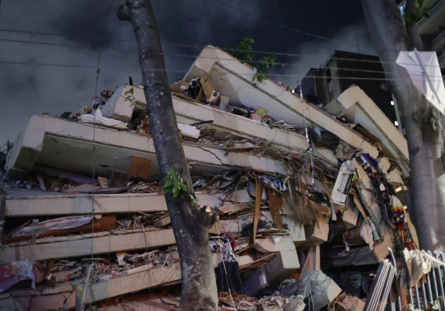
    Two shallow earthquakes of magnitude 7.1 and 6.8 struck near Caracas and La Guaira within hours, collapsing mid‑rise reinforced concrete apartment blocks and older unreinforced masonry in hillside barrios, with hundreds confirmed dead and thousands displaced. Liquefaction, lateral spreading and rockfalls have damaged key transport links, including sections of the Caracas–La Guaira motorway and port access roads, complicating access for rescue equipment and temporary shoring. Geotechnical teams are racing to assess slope stability on steep, weathered tropical soils and to prioritise demolition versus retrofit of heavily cracked shear‑wall structures.

    Technical Brief

    • Emergency engineers are using rapid visual screening to tag buildings red/yellow/green for entry and shoring.
    • Failure investigations will focus on soft-storey mechanisms, captive columns and poor confinement detailing in RC frames.
    • Port and motorway embankments are being inspected for settlement, cracking and lateral spreading before reopening to heavy traffic.
    • Monitoring plans include crack gauges on critical shear walls and inclinometers on reactivated slopes above key corridors.
    • For similar high-seismicity urban corridors, results will likely feed into updated local seismic design and retrofit provisions.

    Our Take

    With no specific projects or mine sites flagged in this incident, operators in Caracas and La Guaira should still treat it as a live stress test of lifeline infrastructure—ports, access roads and power corridors—since in our safety-tagged coverage, secondary disruption to logistics often proves more persistent for industry than direct structural damage.

    Geotechnical Software for Modern Teams

    Centralise site data, logs, and lab results with GEODB-io, CMRR-io, and HYDROGEO-io.

    No credit card required.

    • Save and export unlimited calculations
    • Advanced data visualisation
    • Generate professional PDF reports
    • Cloud storage for all your projects

    Prepared by collating external sources, AI-assisted tools, and Geomechanics.io’s proprietary mining database, then reviewed for technical accuracy & edited by our geotechnical team.

    Related Articles

    Met passes Grenfell files to CPS: legal and design lessons for fire engineers
    Hazards
    about 9 hours ago

    Met passes Grenfell files to CPS: legal and design lessons for fire engineers

    Metropolitan Police have submitted 20 investigation files on the Grenfell Tower fire to the Crown Prosecution Service, covering 20 companies and organisations and 54 individuals. Potential charges span corporate manslaughter, gross negligence manslaughter, health and safety offences, fraud and fraud-related offences, and misconduct in public office, following work by a 220-strong investigation team. The CPS aims to issue charging decisions by June 2027, the fire’s tenth anniversary, a timetable relevant for dutyholders involved in high-rise cladding, fire safety design and regulatory compliance.

    GAD–ORR climate hazard analysis: resilience and asset risk insights for engineers
    Hazards
    2 days ago

    GAD–ORR climate hazard analysis: resilience and asset risk insights for engineers

    Government Actuary’s Department actuaries have delivered probabilistic analysis to the Office of Rail and Road on how climate-related hazards such as extreme rainfall, heat and flooding are evolving across UK rail and strategic road assets. Using long‑term climate projections and hazard frequency–severity modelling, the work maps where risks to embankments, cuttings, track buckling and drainage exceedances are likely to increase. The outputs will feed into ORR’s scrutiny of Network Rail and National Highways’ asset management, resilience upgrades and future capital planning.

    Donlin mine tailings spill scenario: design and risk lessons for engineers
    Hazards
    4 days ago

    Donlin mine tailings spill scenario: design and risk lessons for engineers

    A new draft supplemental environmental impact statement from the US Army Corps of Engineers and BLM models a 27% tailings storage facility failure at NOVAGOLD’s proposed Donlin Gold mine in Alaska, warning a toxic wave could reach Crooked Creek village in 90 minutes, bury it in tailings and leave metal contamination in the Kuskokwim River basin for more than a century. The scenario, far larger than the previously assessed 0.5% spill, projects long-term erosion, groundwater mounding, altered stream channels and persistent reductions in fish abundance, with NGOs demanding analysis of a full dam failure. The 40-million-ounce, 2.22 g/t deposit is permitted for 1.1 million ounces per year over 27 years, but the SEIS outcome could modify, reaffirm or rescind the existing federal permit.

    Related Industries & Products

    Construction

    Quality control software for construction companies with material testing, batch tracking, and compliance management.

    Mining

    Geotechnical software solutions for mining operations including CMRR analysis, hydrogeological testing, and data management.

    CMRR-io

    Streamline coal mine roof stability assessments with our cloud-based CMRR software featuring automated calculations, multi-scenario analysis, and collaborative workflows.

    HYDROGEO-io

    Comprehensive hydrogeological testing platform for managing, analysing, and reporting on packer tests, lugeon values, and hydraulic conductivity assessments.

    GEODB-io

    Centralised geotechnical data management solution for storing, accessing, and analysing all your site investigation and material testing data.

    AllGeotechnicalInfrastructureHazardsEnvironmental