Geomechanics.io

  • Free Tools
Sign UpLog In

Geomechanics.io

Geomechanics, Streamlined.

© 2026 Geomechanics.io. All rights reserved.

Geomechanics.io

CMRR-ioGEODB-ioHYDROGEO-ioQCDB-ioFree Tools & CalculatorsBlogLatest Industry News

Industries

MiningConstructionTunnelling

Company

Terms of UsePrivacy PolicyLinkedIn
    Projects
    Safety
    Sustainability

    Thames Estuary sea level rise: design implications for flood defences to 2100

    August 12, 2026|

    Reviewed by Tom Sullivan

    Thames Estuary sea level rise: design implications for flood defences to 2100

    First reported on New Civil Engineer

    30 Second Briefing

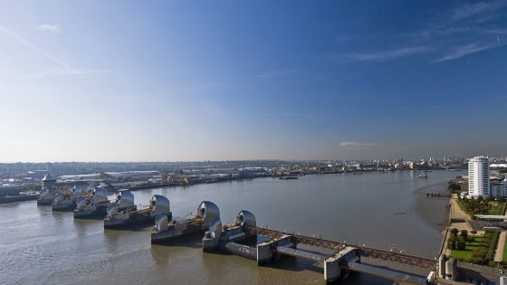
    A 15‑year review of the Environment Agency’s Thames Estuary 2100 (TE2100) Plan finds sea levels in the estuary are rising faster than earlier design assumptions, putting additional pressure on the 520‑square‑kilometre flood risk management area. The findings are expected to trigger earlier or more extensive upgrades to defences including the Thames Barrier, raised tidal walls and embankments, and secondary barriers on tributaries. For geotechnical and civil engineers, this signals a need to revisit crest levels, overtopping criteria, and foundation performance under higher hydraulic loading over the plan horizon to 2100.

    Technical Brief

    • Governance structure ties barrier, wall and embankment interventions to trigger levels derived from observed sea‑level trends.
    • Safety management is framed around maintaining a defined standard of protection for existing communities and critical infrastructure.
    • Findings feed into asset management plans for the Thames Barrier and associated gates, sluices and embankments.
    • Revised projections will influence timing of capital works, including potential new or raised secondary barriers on tributaries.
    • Updated hazard information is expected to tighten design checks on residual risk, emergency drawdown and evacuation planning.
    • Similar long‑horizon coastal strategies will likely need earlier re‑validation of climate allowances and defence crest assumptions.

    Our Take

    A 15‑year review cycle for the TE2100 Plan implies that asset data, modelling outputs and design assumptions will need to be revalidated against evolving climate and sea‑level scenarios, which aligns with New Civil Engineer’s separate coverage of ‘data handover gaps’ on major infrastructure and suggests flood authorities will increasingly demand robust, interoperable asset information from designers.

    For practitioners, the faster‑than‑expected rise in the Thames Estuary raises the likelihood that some interventions originally scheduled towards the back end of the 2100 horizon will be pulled forward, affecting project phasing, capex timing and potentially the design criteria for bridges, tunnels and other critical infrastructure crossing the estuary.

    Geotechnical Software for Modern Teams

    Centralise site data, logs, and lab results with GEODB-io, CMRR-io, and HYDROGEO-io.

    No credit card required.

    • Save and export unlimited calculations
    • Advanced data visualisation
    • Generate professional PDF reports
    • Cloud storage for all your projects

    Prepared by collating external sources, AI-assisted tools, and Geomechanics.io’s proprietary mining database, then reviewed for technical accuracy & edited by our geotechnical team.

    Related Articles
    South Africa chrome mine cave-in: geotechnical failure lessons for engineers
    Hazards
    about 16 hours ago

    South Africa chrome mine cave-in: geotechnical failure lessons for engineers

    Fourteen illegal chrome miners were found dead and at least eight injured after a cave-in near an abandoned shaft by the Nkaneng informal settlement, close to Marikana in South Africa’s North West province, with the collapse estimated around 21:00 on Monday. Police have intensified action against illegal chrome operations in the province, seizing 20 trucks and 15 excavators over the past two years and arresting survivors on suspicion of illegal mining. The incident underlines ongoing geotechnical and safety risks where informal miners re-enter abandoned gold, platinum and chrome workings without ground support or regulated access control.

    Sellafield worker death: ONR findings and safety oversight notes for engineers
    Hazards
    29 days ago

    Sellafield worker death: ONR findings and safety oversight notes for engineers

    A worker at the Sellafield nuclear decommissioning site “died suddenly” during the week commencing 6 July, prompting an immediate review by the Office for Nuclear Regulation (ONR). ONR has confirmed the death was not work-related and that there was no radiological or conventional safety incident affecting the wider site. Routine regulatory oversight of Sellafield’s legacy waste facilities, spent fuel management and construction activities continues unchanged, with no impact reported on nuclear safety cases or site operations.

    BGS River Tweed groundwater survey: flood model lessons for infrastructure engineers
    Hazards
    about 1 month ago

    BGS River Tweed groundwater survey: flood model lessons for infrastructure engineers

    The British Geological Survey has launched a four‑year ground investigation of the River Tweed catchment to characterise groundwater behaviour and its interaction with river levels for improved flood forecasting. Work will include installing new monitoring boreholes, logging groundwater heads and flow paths, and integrating hydrogeological data with existing river‑gauge and rainfall records across the cross‑border catchment. Findings are expected to refine flood models used by local authorities and infrastructure owners, particularly for groundwater‑dominated flood events and prolonged saturation of transport and drainage assets.

    Related Industries & Products

    Construction

    Quality control software for construction companies with material testing, batch tracking, and compliance management.

    Mining

    Geotechnical software solutions for mining operations including CMRR analysis, hydrogeological testing, and data management.

    CMRR-io

    Streamline coal mine roof stability assessments with our cloud-based CMRR software featuring automated calculations, multi-scenario analysis, and collaborative workflows.

    HYDROGEO-io

    Comprehensive hydrogeological testing platform for managing, analysing, and reporting on packer tests, lugeon values, and hydraulic conductivity assessments.

    GEODB-io

    Centralised geotechnical data management solution for storing, accessing, and analysing all your site investigation and material testing data.

    AllGeotechnicalInfrastructureHazardsEnvironmental