Geomechanics.io

  • Free Tools
Sign UpLog In

Geomechanics.io

Geomechanics, Streamlined.

© 2026 Geomechanics.io. All rights reserved.

Geomechanics.io

CMRR-ioGEODB-ioHYDROGEO-ioQCDB-ioFree Tools & CalculatorsBlogLatest Industry News

Industries

MiningConstructionTunnelling

Company

Terms of UsePrivacy PolicyLinkedIn
    Projects

    Northern Ireland DfI AI road stock-take: asset management lessons for engineers

    December 6, 2025|

    Reviewed by Joe Ashwell

    Northern Ireland DfI AI road stock-take: asset management lessons for engineers

    First reported on New Civil Engineer

    30 Second Briefing

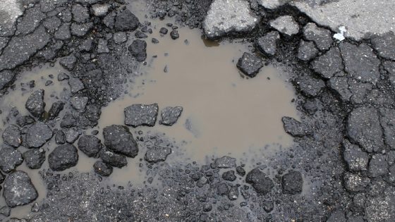
    Northern Ireland’s Department for Infrastructure has commissioned mapping specialist Gaist to deliver a network-wide digital stock-take of its road assets using AI-based condition assessment. High-resolution imaging and machine-learning classification will be used to catalogue carriageway defects, drainage features and street furniture, creating a georeferenced inventory to support maintenance planning amid a mounting roads backlog. For asset managers and pavement engineers, the move signals a shift towards data-driven prioritisation of resurfacing, patching and drainage interventions across the regional network.

    Technical Brief

    • Centralised digital baselines allow future surveys to be compared for deterioration rates and treatment performance.

    Our Take

    Among the 174 Infrastructure stories in our coverage, AI is still relatively niche, so DfI’s use of Gaist’s tools in Northern Ireland positions it alongside only a small subset of UK transport authorities experimenting with AI-led asset condition surveys.

    For UK public bodies like the Department for Infrastructure, AI-based ‘digital stock-takes’ typically become a prerequisite for moving from reactive pothole repairs to risk-based, whole‑network maintenance planning, which can materially change how budgets are defended in Treasury negotiations.

    Because Northern Ireland’s local road network has historically had patchier condition data than some Great Britain regions in our database, a comprehensive AI-derived inventory is likely to expose a larger backlog than legacy records suggest, which can sharpen but also politically complicate prioritisation decisions.

    Geotechnical Software for Modern Teams

    Centralise site data, logs, and lab results with GEODB-io, CMRR-io, and HYDROGEO-io.

    No credit card required.

    • Save and export unlimited calculations
    • Advanced data visualisation
    • Generate professional PDF reports
    • Cloud storage for all your projects

    Prepared by collating external sources, AI-assisted tools, and Geomechanics.io’s proprietary mining database, then reviewed for technical accuracy & edited by our geotechnical team.

    Related Articles

    Strabag’s Pfaffensteig Tunnel contract: design and delivery notes for rail engineers
    Infrastructure
    about 1 month ago

    Strabag’s Pfaffensteig Tunnel contract: design and delivery notes for rail engineers

    Strabag and Group company Züblin have secured the design-and-build structural works for the ABS Gäubahn Nord/Pfaffensteig Tunnel in south-west Germany, centred on an 11km twin-bore rail tunnel linking Stuttgart Airport station directly to the Gäubahn line towards Switzerland. About 9.8km will be driven by two TBMs, with conventional tunnelling for the A8 motorway undercrossing and airport connection, plus a 240m cut-and-cover section, retaining structures, railway underpasses and a grade-separated crossing. A 3km surface section will be upgraded and partially realigned for 200km/h operation, delivered under an integrated project delivery model with Ed. Züblin, Wayss & Freytag and Strabag AG sharing tunnelling, structural and earthworks packages.

    National Grid TBM under the Thames: tunnelling design and risk notes for engineers
    Infrastructure
    3 months ago

    National Grid TBM under the Thames: tunnelling design and risk notes for engineers

    A 271.5‑tonne Herrenknecht Mixshield TBM, Caroline, has started driving a 2.2km electricity cable tunnel with a 4m internal diameter beneath the River Thames in Essex for National Grid’s Grain to Tilbury project, delivered by the Ferrovial BEMO joint venture. The drive will pass through variable Thames estuary ground conditions between 35m‑deep launch and reception shafts of 15m and 12m diameter, with tunnelling continuing into 2026 and overall scheme completion targeted for 2029. The new tunnel will replace the 1969 Thames Cable Tunnel and carry new high‑voltage circuits between Grain and Tilbury substations.

    Panama Canal Mixshield undercrossing: design and tunnelling lessons for engineers
    Infrastructure
    4 months ago

    Panama Canal Mixshield undercrossing: design and tunnelling lessons for engineers

    A 13.46m diameter Herrenknecht Mixshield TBM has broken through into the future Balboa station on Panama Metro Line 3 after completing the first-ever TBM undercrossing of the Panama Canal at depths exceeding 60m below sea level. The 5,600kW, 26,616kNm machine, fitted with an accessible cutterhead and more than 4,500 sensors linked via the Herrenknecht.Connected platform, has achieved peak advance of 150 segment rings (about 300m) per month through mixed sandstone, tuff, breccias and basalt. Around 1.5km of the 4.5km twin-track tunnel remains to final breakthrough.

    Related Industries & Products

    Mining

    Geotechnical software solutions for mining operations including CMRR analysis, hydrogeological testing, and data management.

    Construction

    Quality control software for construction companies with material testing, batch tracking, and compliance management.

    CMRR-io

    Streamline coal mine roof stability assessments with our cloud-based CMRR software featuring automated calculations, multi-scenario analysis, and collaborative workflows.

    HYDROGEO-io

    Comprehensive hydrogeological testing platform for managing, analysing, and reporting on packer tests, lugeon values, and hydraulic conductivity assessments.

    GEODB-io

    Centralised geotechnical data management solution for storing, accessing, and analysing all your site investigation and material testing data.

    AllGeotechnicalMiningInfrastructureMaterialsHazardsEnvironmentalSoftwarePolicy