Geomechanics.io

  • Free Tools
Sign UpLog In

Geomechanics.io

Geomechanics, Streamlined.

© 2026 Geomechanics.io. All rights reserved.

Geomechanics.io

CMRR-ioGEODB-ioHYDROGEO-ioQCDB-ioFree Tools & CalculatorsBlogLatest Industry News

Industries

MiningConstructionTunnelling

Company

Terms of UsePrivacy PolicyLinkedIn
    Projects
    Research
    Safety

    Levee Digital Twin Platform for Yuba River: condition monitoring insights for engineers

    June 12, 2026|

    Reviewed by Tom Sullivan

    Levee Digital Twin Platform for Yuba River: condition monitoring insights for engineers

    First reported on Geoengineer.org – News

    30 Second Briefing

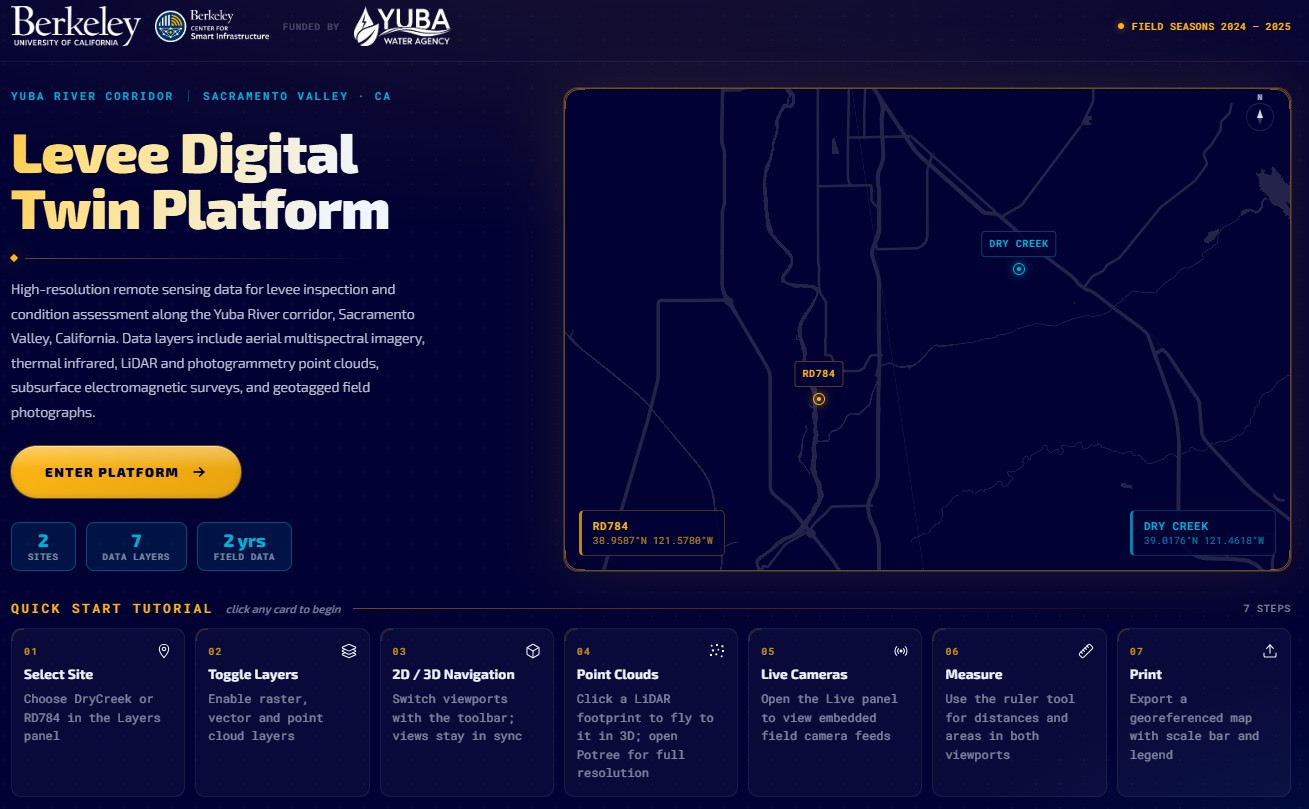
    Researchers at UC Berkeley, funded by Yuba Water, have launched a Levee Digital Twin Platform for the Yuba River corridor, integrating continuous sensor data, geotechnical models and inspection records into an interactive system for levee condition assessment. The platform combines real-time pore pressure and deformation monitoring with historical performance data to flag anomalous behaviour along specific reaches and embankment sections. Engineers can use the tool to prioritise field investigations, refine seepage and stability analyses, and plan targeted remediation before high-flow events.

    Technical Brief

    • Approach provides a template for regulated levee systems globally where dispersed legacy data hinder risk-based safety management.

    Our Take

    Because this piece is tagged under both Research and Safety, it aligns with a small subset of geotechnical coverage where academic institutions like UC Berkeley are directly embedded in operational risk management, which often accelerates the transfer of new modelling methods into agency practice.

    For operators such as Yuba Water, a corridor-scale digital twin in the United States context typically implies better support for real-time flood operations and capital planning, potentially influencing how other Californian water agencies justify upgrades and monitoring spend to regulators and funders.

    Geotechnical Software for Modern Teams

    Centralise site data, logs, and lab results with GEODB-io, CMRR-io, and HYDROGEO-io.

    No credit card required.

    • Save and export unlimited calculations
    • Advanced data visualisation
    • Generate professional PDF reports
    • Cloud storage for all your projects

    Prepared by collating external sources, AI-assisted tools, and Geomechanics.io’s proprietary mining database, then reviewed for technical accuracy & edited by our geotechnical team.

    Related Articles

    CAPG panel at ICSMGE 2026: digital, testing and risk takeaways for geotechnical teams
    Geotechnical
    about 3 hours ago

    CAPG panel at ICSMGE 2026: digital, testing and risk takeaways for geotechnical teams

    The Corporate Associates Presidential Group of ISSMGE will run a dedicated panel at the 21st International Conference on Soil Mechanics and Geotechnical Engineering in Vienna in 2026, focusing on the future of geotechnical engineering practice. Industry leaders from major consulting firms, contractors and equipment suppliers are expected to address digital design workflows, advanced in situ testing, and risk allocation in large infrastructure projects. Outcomes are likely to influence updates to corporate design standards, procurement strategies and adoption of emerging investigation and monitoring technologies.

    Geoquest geosynthetics in Australian roads: design and risk notes for engineers
    Geotechnical
    3 days ago

    Geoquest geosynthetics in Australian roads: design and risk notes for engineers

    Geosynthetics are moving from niche products to standard tools for Australian infrastructure delivery as Geoquest deploys geogrids, geotextiles and geocells to tackle increasingly poor ground and constrained project footprints. The company is customising reinforced soil structures, basal reinforcement and pavement subgrade improvement systems to reduce imported fill volumes, shorten construction programmes and enable construction over soft clays and variable alluvium that would previously require deep piling. For practitioners, the shift allows slimmer pavement designs, higher embankments on marginal soils and more predictable deformation behaviour under traffic loading.

    Vinci–Grupo TDM geosynthetics deal: design–build implications for Andean TSFs
    Geotechnical
    3 days ago

    Vinci–Grupo TDM geosynthetics deal: design–build implications for Andean TSFs

    Vinci Construction has expanded its Latin American ground technologies portfolio by acquiring Grupo TDM’s geosynthetics division in Peru, a regional supplier of geotextiles, geomembranes and geogrids for mining, road and hydraulic works. The deal gives Vinci direct control of design–supply–install capability for reinforced soil walls, basal reinforcement and lining systems on high-embankment highways and tailings storage facilities in the Andes. For geotechnical contractors and designers, this signals stronger OEM-backed support for geosynthetic solutions on steep slopes, soft-ground foundations and aggressive seismic conditions in the region.

    Related Industries & Products

    Mining

    Geotechnical software solutions for mining operations including CMRR analysis, hydrogeological testing, and data management.

    CMRR-io

    Streamline coal mine roof stability assessments with our cloud-based CMRR software featuring automated calculations, multi-scenario analysis, and collaborative workflows.

    HYDROGEO-io

    Comprehensive hydrogeological testing platform for managing, analysing, and reporting on packer tests, lugeon values, and hydraulic conductivity assessments.

    GEODB-io

    Centralised geotechnical data management solution for storing, accessing, and analysing all your site investigation and material testing data.

    AllGeotechnicalMiningInfrastructureMaterialsHazardsEnvironmentalSoftwarePolicy