1960s cold case ground investigation: forensic lessons for geotechnical teams
Reviewed by Joe Ashwell
First reported on New Civil Engineer
30 Second Briefing
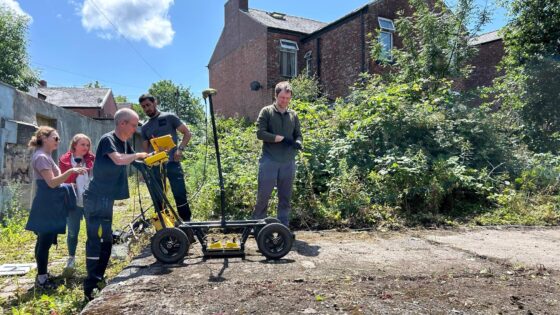
Ground investigation techniques typically used for highways and foundations have been deployed in a 1960s missing person cold case, with RSK geophysicists leading the subsurface search. The team is combining ground-penetrating radar (GPR) with intrusive investigation methods such as boreholes or trial pits to characterise stratigraphy and detect potential burial anomalies. The work shows how standard site investigation tools can be adapted for forensic applications, including in constrained or previously disturbed ground.
Technical Brief
- Forensic deployment required tight coordination with police search protocols and evidential chain-of-custody requirements.
- Survey design had to respect potential crime scene integrity, limiting disturbance from intrusive investigation points.
- Legacy land use and subsequent site disturbance complicated interpretation of subsurface anomalies and stratigraphy.
- Health and safety controls mirrored construction ground investigation, with exclusion zones around plant and intrusive works.
- Data acquisition windows were constrained by daylight, public access management and police operational schedules.
- Findings informed targeted excavation decisions by law enforcement, reducing unnecessary ground disturbance and associated risk.
- Similar forensic applications are likely to influence future GI method statements where police or coronial interfaces exist.
Our Take
RSK’s role in this cold case sits alongside its work on complex brownfield and quarry projects in our database, such as the Fort Halstead redevelopment and the Cheshire silica sand quarry solar scheme, underlining how its ground investigation expertise is being applied in non-traditional, forensic contexts as well as mainstream construction.
For practitioners, the crossover between forensic ground investigation here and RSK’s brownfield work for Barratt David Wilson Homes Kent signals that techniques validated in legal or evidential settings may increasingly be expected as best practice documentation standards on safety-tagged civil projects.
Prepared by collating external sources, AI-assisted tools, and Geomechanics.io’s proprietary mining database, then reviewed for technical accuracy & edited by our geotechnical team.
Related Articles

Related Industries & Products
Construction
Quality control software for construction companies with material testing, batch tracking, and compliance management.
Mining
Geotechnical software solutions for mining operations including CMRR analysis, hydrogeological testing, and data management.
HYDROGEO-io
Comprehensive hydrogeological testing platform for managing, analysing, and reporting on packer tests, lugeon values, and hydraulic conductivity assessments.
GEODB-io
Centralised geotechnical data management solution for storing, accessing, and analysing all your site investigation and material testing data.
QCDB-io
Comprehensive quality control database for manufacturing, tunnelling, and civil construction with UCS testing, PSD analysis, and grout mix design management.