Geomechanics.io

  • Free Tools
Sign UpLog In

    Geomechanics.io

    Geomechanics, Streamlined.

    © 2026 Geomechanics.io. All rights reserved.

    Geomechanics.io

    CMRR-ioGEODB-ioHYDROGEO-ioQCDB-ioFree Tools & CalculatorsBlogLatest Industry News

    Industries

    MiningConstructionTunnelling

    Company

    Terms of UsePrivacy PolicyLinkedIn
    Projects
    Sustainability
    Safety

    Helicopter mine remediation at Nant y Mwyn: design and water quality notes for engineers

    April 9, 2026|

    Reviewed by Tom Sullivan

    Helicopter mine remediation at Nant y Mwyn: design and water quality notes for engineers

    First reported on The Construction Index

    30 Second Briefing

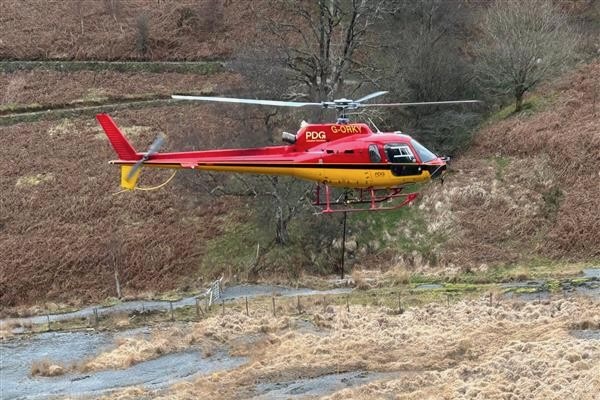
    Natural Resources Wales and the Coal Authority’s Mining Remediation Authority used a PDG helicopter to place 109 bags of stabilisation material along the Nant y Bai riverbank at Nant y Mwyn lead mine, Carmarthenshire, where about 300m³ of spoil was at immediate risk of being washed into the river. The airlift avoided haul roads and heavy plant, limiting ground disturbance and allowing follow‑up hand work to protect rare grassland around the site. Reducing severe spoil erosion is expected to cut cadmium and zinc loading to the Afon Tywi, currently elevated for up to 25 km downstream.

    Technical Brief

    • Nant y Mwyn remediation forms part of the Welsh Government-funded Wales Metal Mines Programme for high-risk legacy sites.
    • Severe spoil erosion along Nant y Bai currently contributes several tonnes of metal contaminants annually to the Afon Tywi.
    • Elevated cadmium and zinc concentrations persist for up to 25 km downstream of the mine, indicating chronic water-quality exceedances.
    • Works were deliberately scheduled before lambing and bird-nesting seasons to comply with ecological timing constraints.
    • Hand placement of materials was mandated in sensitive zones to protect rare grassland and heritage features from mechanical damage.
    • Similar abandoned metal mine sites with steep river-adjacent spoil heaps could adopt helicopter placement to meet strict habitat protections.

    Our Take

    The use of helicopter placement for stabilising material at Nant y Mwyn Mine suggests access or ground-stability constraints severe enough that conventional earthmoving would pose higher safety or erosion risk, a pattern also seen in other steep or highly weathered former metal mines in our database.

    With cadmium and zinc both flagged in the 173 keyword-matched pieces, this incident reinforces that legacy polymetallic lead sites in the United Kingdom often require multi-contaminant strategies rather than single-metal clean-ups, influencing how programmes such as The Wales Metal Mines Programme scope future works and budgets.

    Geotechnical Software for Modern Teams

    Centralise site data, logs, and lab results with GEODB-io, CMRR-io, and HYDROGEO-io.

    No credit card required.

    • Save and export unlimited calculations
    • Advanced data visualisation
    • Generate professional PDF reports
    • Cloud storage for all your projects

    Prepared by collating external sources, AI-assisted tools, and Geomechanics.io’s proprietary mining database, then reviewed for technical accuracy & edited by our geotechnical team.

    Related Articles

    £44.7M Welsh Water enforcement package: design and upgrade notes for engineers
    Environmental
    about 11 hours ago

    £44.7M Welsh Water enforcement package: design and upgrade notes for engineers

    Ofwat has accepted a £44.7M enforcement package from Dŵr Cymru Welsh Water to remediate wastewater network failures and cut sewage spills across Wales. The measures will target storm overflows and underperforming treatment works, with investment directed to upgrading sewer infrastructure, increasing storage capacity and improving process control at key wastewater treatment plants. For civil and environmental engineers, the programme signals near-term demand for hydraulic modelling, network rehabilitation, and construction of additional attenuation and treatment assets under tighter regulatory scrutiny.

    Environment Agency flood risk framework: design and modelling lens for engineers
    Environmental
    about 12 hours ago

    Environment Agency flood risk framework: design and modelling lens for engineers

    The Environment Agency has appointed a consortium led by AtkinsRéalis, with Stantec and Waterman as subconsultants, to deliver professional services for a new flood and coastal risk management framework across England. The framework will support planning, design and appraisal of defences and nature-based solutions for rivers, estuaries and coasts, shaping future capital works and asset management programmes. Consultants can expect significant workloads in hydraulic modelling, coastal processes, climate change allowances and whole-life risk assessments for Environment Agency schemes.

    Nova and RSK Cheshire quarry floating solar: design and stability notes for engineers
    Environmental
    5 days ago

    Nova and RSK Cheshire quarry floating solar: design and stability notes for engineers

    Nova has switched on a floating solar farm at a Cheshire silica sand quarry, delivering on-site power generation for one of the UK’s largest producers of high-quality industrial silica sand. Developed with environmental consultancy RSK, the array is mounted on a buoyant platform system on the quarry lake, preserving limited land area for extraction and processing infrastructure. The installation reduces grid dependence for energy-intensive washing and grading plant, and will require geotechnical and hydraulic checks on anchoring, bank stability and water-level variability over the quarry’s remaining life.

    Related Industries & Products

    Mining

    Geotechnical software solutions for mining operations including CMRR analysis, hydrogeological testing, and data management.

    CMRR-io

    Streamline coal mine roof stability assessments with our cloud-based CMRR software featuring automated calculations, multi-scenario analysis, and collaborative workflows.

    HYDROGEO-io

    Comprehensive hydrogeological testing platform for managing, analysing, and reporting on packer tests, lugeon values, and hydraulic conductivity assessments.

    GEODB-io

    Centralised geotechnical data management solution for storing, accessing, and analysing all your site investigation and material testing data.

    AllGeotechnicalInfrastructureHazardsEnvironmental