Godstone sinkhole repairs: investigation and design lessons for road engineers
Reviewed by Joe Ashwell
First reported on New Civil Engineer
30 Second Briefing
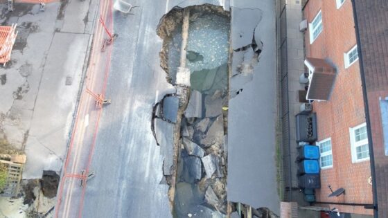
Final repairs have been completed on Godstone High Street, Surrey, 18 months after a major sinkhole caused a full closure and extensive ground stabilisation works. Engineers had to rebuild the carriageway and underlying formation, install new buried services and reinstate drainage after the collapse exposed significant voiding beneath the road. The incident is prompting local authorities and designers to review ground investigation scope, utility mapping and monitoring on similar chalk and solution-feature-prone corridors.
Technical Brief
- Failure mechanism involved collapse into pre-existing chalk solution features, with voids propagating along service corridors.
- Investigation relied on targeted boreholes and dynamic probing to trace lateral extent of karstic voiding.
- Ground-penetrating radar and CCTV surveys were used to locate undermined utilities and hidden cavities beneath the carriageway.
- Remediation design adopted staged bulk infill of voids with low-shrink cementitious grout to avoid further loosening.
- Ongoing monitoring includes periodic level surveys of the carriageway and manholes to detect post-repair settlement.
Our Take
An 18‑month closure for a ground failure in Godstone sits at the more disruptive end of the 18 Hazards stories in our database, signalling that even localised collapses in the United Kingdom can have project-scale programme and diversion impacts similar to major infrastructure incidents.
Because New Civil Engineer also hosts webinars on BIM, CDEs and asset management platforms, this sinkhole case is likely to feed into emerging UK practice on using digital condition data to flag voiding or subsidence risks before they trigger long-duration closures.
For practitioners in Surrey and comparable UK settings, a failure that shuts a high street for over a year underscores the value of pre‑incident ground investigation and contingency planning within town-centre projects, not just on large linear infrastructure schemes that typically dominate safety discussions in our coverage.
Prepared by collating external sources, AI-assisted tools, and Geomechanics.io’s proprietary mining database, then reviewed for technical accuracy & edited by our geotechnical team.
Related Articles

Related Industries & Products
Construction
Quality control software for construction companies with material testing, batch tracking, and compliance management.
Mining
Geotechnical software solutions for mining operations including CMRR analysis, hydrogeological testing, and data management.
CMRR-io
Streamline coal mine roof stability assessments with our cloud-based CMRR software featuring automated calculations, multi-scenario analysis, and collaborative workflows.
HYDROGEO-io
Comprehensive hydrogeological testing platform for managing, analysing, and reporting on packer tests, lugeon values, and hydraulic conductivity assessments.
GEODB-io
Centralised geotechnical data management solution for storing, accessing, and analysing all your site investigation and material testing data.