Geomechanics.io

  • Free Tools
Sign UpLog In

Geomechanics.io

Geomechanics, Streamlined.

© 2026 Geomechanics.io. All rights reserved.

Geomechanics.io

CMRR-ioGEODB-ioHYDROGEO-ioQCDB-ioFree Tools & CalculatorsBlogLatest Industry News

Industries

MiningConstructionTunnelling

Company

Terms of UsePrivacy PolicyLinkedIn
    Projects
    Research
    Safety
    Sustainability

    Deep-sea mining trial impacts on seabed fauna: key findings for project teams

    December 11, 2025|

    Reviewed by Joe Ashwell

    Deep-sea mining trial impacts on seabed fauna: key findings for project teams

    First reported on MINING.com

    30 Second Briefing

    Deep-sea mining tests in the Clarion–Clipperton Zone at 4,280 metres depth, commissioned by Nauru Ocean Resources (a The Metals Company subsidiary), cut macrofaunal density by 37% and species richness by 32% along machine tracks over two years, based on disturbance of 3,000 tonnes of polymetallic nodules. European researchers from the Natural History Museum, University of Gothenburg and the National Oceanography Centre collected 4,350 sediment macrofaunal animals and identified 788 species, mainly polychaete worms, crustaceans and molluscs. The trial used machines only about half the size of planned commercial systems, raising concern that full-scale operations could cause larger, possibly irreversible, benthic impacts.

    Technical Brief

    • Trial disturbed 3,000 tonnes of polymetallic nodules in the Clarion–Clipperton Zone, central Pacific.
    • Work was conducted at 4,280 m water depth, within Nauru Ocean Resources’ NORI contract area.
    • Research campaign spanned five years, including >160 ship-days and ~3 years of laboratory analysis.
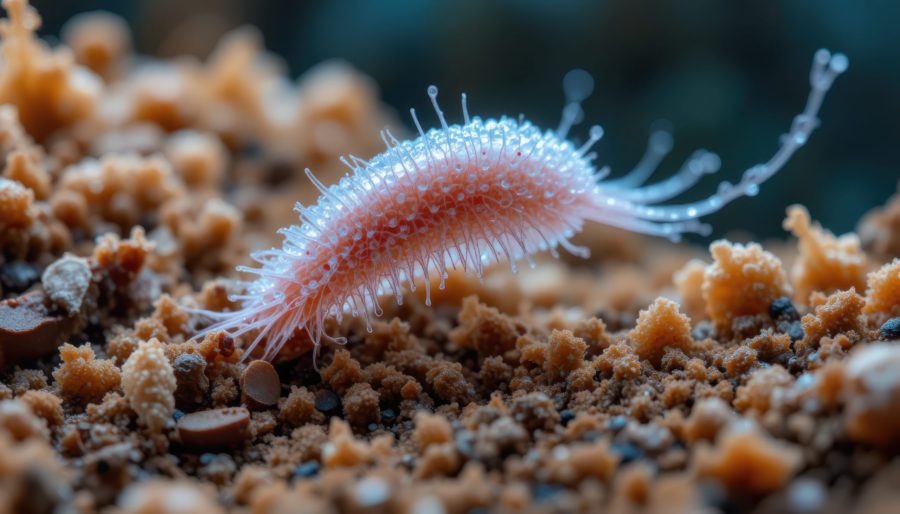
    • Sampling across four expeditions recovered 4,350 sediment macrofaunal specimens, classified into 788 distinct species.
    • Taxa were dominated by polychaete annelids, followed by isopods, tanaids, amphipods, snails and clams.
    • A new solitaire coral species was discovered, indicating incomplete baseline biodiversity knowledge in the CCZ.
    • Authors note impacts were assessed mainly for sediment-dwelling macrofauna, so responses of megafauna and pelagic biota remain unresolved.

    Our Take

    With an estimated 21 billion tonnes of minerals in the Clarion–Clipperton Zone, the 37% macrofaunal density and 32% species richness losses reported here sharpen the trade-off facing cobalt and nickel supply chains that are already under pressure from 2025 quota discussions in conventional producers such as Congo.

    The CCZ’s 6 million km² footprint means that even localised disturbance patterns, if repeated across multiple licence blocks held by operators like Nauru Ocean Resources (linked to The Metals Company), could scale into basin-level ecological change that regulators will need to factor into ISA exploitation rules.

    Among our relatively few Environmental stories, this is one of the more data-rich deep-sea pieces, and the 788 species identified will likely become a reference baseline for future impact assessments that battery-metal offtakers and ESG auditors demand from Pacific polymetallic nodule projects.

    Geotechnical Software for Modern Teams

    Centralise site data, logs, and lab results with GEODB-io, CMRR-io, and HYDROGEO-io.

    No credit card required.

    • Save and export unlimited calculations
    • Advanced data visualisation
    • Generate professional PDF reports
    • Cloud storage for all your projects

    Prepared by collating external sources, AI-assisted tools, and Geomechanics.io’s proprietary mining database, then reviewed for technical accuracy & edited by our geotechnical team.

    Related Articles

    Embedding biodiversity metrics: design and earthworks notes for engineers
    Environmental
    2 days ago

    Embedding biodiversity metrics: design and earthworks notes for engineers

    Construction clients and contractors are starting to embed biodiversity metrics alongside whole‑life carbon assessment, using quantified habitat units and standardised biodiversity net gain (BNG) calculators to track performance through design, procurement and delivery. Supply chains are being asked to evidence habitat creation, connectivity and species outcomes in product data sheets and contracts, linking materials choices and temporary works to measurable on‑site ecological change rather than qualitative statements. For geotechnical and civil teams, this signals future schemes where cut‑and‑fill, drainage, earthworks phasing and landscape design must all be optimised against both carbon and biodiversity targets.

    Natural England nutrients scheme: design implications for Stodmarsh drainage teams
    Environmental
    5 days ago

    Natural England nutrients scheme: design implications for Stodmarsh drainage teams

    Natural England has approved the Stodmarsh stream enhancement scheme under the Habitats Regulations, unlocking nutrient neutrality credits to support several thousand new homes around Ashford, Kent. The scheme centres on watercourse and wetland improvements in the Stodmarsh catchment to offset additional nitrogen and phosphorus loads from new foul drainage. Planners, drainage designers and geotechnical teams will need to integrate on-site attenuation, SuDS and connection strategies that align with the credit conditions tied to the Stodmarsh enhancement works.

    The Metals Company deep-sea data dump: EIA and design notes for engineers
    Environmental
    8 days ago

    The Metals Company deep-sea data dump: EIA and design notes for engineers

    The Metals Company’s NORI and TOML subsidiaries have submitted 2013–2022 exploration data from the eastern Clarion‑Clipperton Zone to the ISA’s DeepData system, including 777 equipment deployments, over 4,800 environmental samples, 76,000 biological records and 69,185 geochemical data points from depths beyond 4,000 m. The dataset now accounts for roughly one‑third of all CCZ entries in DeepData and 54% of biological records in the OBIS‑ISA node, positioning it as a key reference for Environmental Impact Assessments. TMC argues this evidence base is sufficient to start monitored commercial nodule collection, despite ongoing calls from NGOs for a moratorium.

    Related Industries & Products

    Mining

    Geotechnical software solutions for mining operations including CMRR analysis, hydrogeological testing, and data management.

    CMRR-io

    Streamline coal mine roof stability assessments with our cloud-based CMRR software featuring automated calculations, multi-scenario analysis, and collaborative workflows.

    HYDROGEO-io

    Comprehensive hydrogeological testing platform for managing, analysing, and reporting on packer tests, lugeon values, and hydraulic conductivity assessments.

    GEODB-io

    Centralised geotechnical data management solution for storing, accessing, and analysing all your site investigation and material testing data.

    AllGeotechnicalInfrastructureHazardsEnvironmental