Geomechanics.io

  • Free Tools
Sign UpLog In

Geomechanics.io

Geomechanics, Streamlined.

© 2026 Geomechanics.io. All rights reserved.

Geomechanics.io

CMRR-ioGEODB-ioHYDROGEO-ioQCDB-ioFree Tools & CalculatorsBlogLatest Industry News

Industries

MiningConstructionTunnelling

Company

Terms of UsePrivacy PolicyLinkedIn
    AllGeotechnicalMiningInfrastructureMaterialsHazardsEnvironmentalSoftwarePolicy
    Projects
    Sustainability

    The Metals Company deep-sea data dump: EIA and design notes for engineers

    April 17, 2026|

    Reviewed by Joe Ashwell

    The Metals Company deep-sea data dump: EIA and design notes for engineers

    First reported on MINING.com

    30 Second Briefing

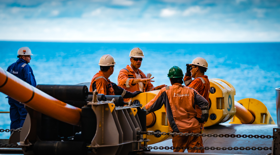
    The Metals Company’s NORI and TOML subsidiaries have submitted 2013–2022 exploration data from the eastern Clarion‑Clipperton Zone to the ISA’s DeepData system, including 777 equipment deployments, over 4,800 environmental samples, 76,000 biological records and 69,185 geochemical data points from depths beyond 4,000 m. The dataset now accounts for roughly one‑third of all CCZ entries in DeepData and 54% of biological records in the OBIS‑ISA node, positioning it as a key reference for Environmental Impact Assessments. TMC argues this evidence base is sufficient to start monitored commercial nodule collection, despite ongoing calls from NGOs for a moratorium.

    Technical Brief

    • Dataset covers abyssal sediments and water column profiling from surface to >4,000 m depth across eastern CCZ.
    • NORI and TOML data collection involved 27 expeditions, including rigorously monitored pilot mining tests.
    • Hundreds of thousands of seafloor images support habitat mapping, nodule field characterisation and faunal distribution analysis.
    • Work is backed by over US$250 million of environmental and resource characterisation investment since 2013.
    • TMC states its findings corroborate NOAA’s 1970s DOMES deep‑ocean mining environmental study outcomes.
    • Environmental Impact Assessment for CCZ nodule collection is now complete and used to justify monitored production.
    • TMC claims CCZ EIAs, in aggregate, exceed the scope of any previous mining project EIAs globally.

    Our Take

    The same Clarion-Clipperton Zone data set now lodged with the ISA and OBIS will likely underpin TMC’s consolidated exploration and commercial recovery permit application that NOAA recently deemed complete, tightening the evidentiary link between environmental baselines and US regulatory review.

    Geotechnical Software for Modern Teams

    Centralise site data, logs, and lab results with GEODB-io, CMRR-io, and HYDROGEO-io.

    No credit card required.

    • Save and export unlimited calculations
    • Advanced data visualisation
    • Generate professional PDF reports
    • Cloud storage for all your projects

    Prepared by collating external sources, AI-assisted tools, and Geomechanics.io’s proprietary mining database, then reviewed for technical accuracy & edited by our geotechnical team.

    Related Articles

    Silt pollution in UK construction: practical control measures for project teams
    Environmental
    3 days ago

    Silt pollution in UK construction: practical control measures for project teams

    Construction’s role in more than one-third of UK carbon emissions is widely acknowledged, but its contribution to acute silt pollution from earthworks, dewatering and runoff from haul roads and stockpiles is still largely overlooked. Fine sediment washed from sites into watercourses can smother spawning gravels, clog culverts and foul SuDS assets, often breaching Environment Agency permits and triggering costly stop-work notices. The piece calls for more rigorous use of silt fences, settlement lagoons and lamella clarifiers, plus better phasing of bulk earthworks to keep disturbed areas and exposed cohesive soils to a minimum.

    FI Real Estate bat roost demolition: licensing and design lessons for project teams
    Environmental
    5 days ago

    FI Real Estate bat roost demolition: licensing and design lessons for project teams

    FI Real Estate Management has been fined £40,000 at Caernarfon magistrates court for unlawfully demolishing buildings on the Peblig Industrial Estate, Caernarfon, that contained bat roosts for three species identified in a 2023 survey. The works proceeded in September 2024 without the required European Protected Species Licence from Natural Resources Wales and before an acceptable replacement bat house design had been agreed with a senior biodiversity officer. The conviction under the Conservation of Habitats and Species Regulations 2017 and the Wildlife and Countryside Act 1981 reinforces that demolition and redevelopment programmes must integrate protected species licensing into design and sequencing.

    DESNZ non-pipeline CO₂ transport pilot: design implications for civil engineers
    Environmental
    9 days ago

    DESNZ non-pipeline CO₂ transport pilot: design implications for civil engineers

    The UK Department for Energy Security and Net Zero has launched a pilot scheme to test non‑pipeline CO₂ transport options to support wider Carbon Capture, Utilisation and Storage deployment beyond fixed trunk lines. The programme will examine road, rail and ship-based movement of captured CO₂ from dispersed industrial sites to storage hubs, targeting clusters that are uneconomic or technically challenging to connect by high-pressure pipeline. For civil and geotechnical engineers, this signals future demand for modular loading terminals, interim storage tanks and upgraded pavements and rail sidings designed for dense liquid CO₂ logistics.

    Related Industries & Products

    Mining

    Geotechnical software solutions for mining operations including CMRR analysis, hydrogeological testing, and data management.

    CMRR-io

    Streamline coal mine roof stability assessments with our cloud-based CMRR software featuring automated calculations, multi-scenario analysis, and collaborative workflows.

    HYDROGEO-io

    Comprehensive hydrogeological testing platform for managing, analysing, and reporting on packer tests, lugeon values, and hydraulic conductivity assessments.

    GEODB-io

    Centralised geotechnical data management solution for storing, accessing, and analysing all your site investigation and material testing data.