Geomechanics.io

  • Free Tools
Sign UpLog In

    Geomechanics.io

    Geomechanics, Streamlined.

    © 2026 Geomechanics.io. All rights reserved.

    Geomechanics.io

    CMRR-ioGEODB-ioHYDROGEO-ioQCDB-ioFree Tools & CalculatorsBlogLatest Industry News

    Industries

    MiningConstructionTunnelling

    Company

    Terms of UsePrivacy PolicyLinkedIn
    Research
    Projects
    Sustainability

    BGS Central North Sea sandstone CO₂ study: storage design insights for engineers

    February 3, 2026|

    Reviewed by Joe Ashwell

    BGS Central North Sea sandstone CO₂ study: storage design insights for engineers

    First reported on New Civil Engineer

    30 Second Briefing

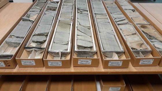
    The British Geological Survey has launched a multi-year programme to map and assess CO₂ storage potential in Triassic and Jurassic sandstone formations beneath the Central North Sea, using legacy hydrocarbon well logs and 3D seismic data. Geoscientists will evaluate porosity–permeability distributions, caprock integrity and pressure limits to define storage units suitable for multi-million-tonne injection linked to UK industrial clusters. Results are expected to guide site selection, well design and monitoring strategies for future offshore carbon storage licences.

    Technical Brief

    • 3D seismic interpretation will be integrated with well correlations to delineate laterally continuous reservoir–seal pairs.
    • Geomechanical modelling will assess in-situ stress regimes and fault reactivation risk under CO₂ injection pressures.
    • Caprock evaluation will focus on shale and mudstone units overlying sandstones, including fault juxtapositions.
    • Outputs are intended to feed into licence-scale dynamic reservoir simulations and plume migration forecasts.
    • Findings are expected to inform offshore well spacing, injector–producer patterns and pressure management strategies.

    Our Take

    Carbon dioxide storage pieces are still only a handful in our Environmental coverage, so work by the British Geological Survey in the Central North Sea signals that subsurface characterisation for CO₂ is moving from concept to more systematic assessment in the UK.

    Using North Sea sandstones for CO₂ storage has strategic implications for the UK, as it can leverage existing offshore infrastructure and skills from hydrocarbons, potentially shortening lead times compared with onshore storage options highlighted in other Environmental research items.

    For UK-based civil and marine contractors, BGS-led appraisal of offshore storage capacity suggests future demand for seabed investigation, well re-entry, and monitoring infrastructure, even though no specific project or licence award is attached to this research yet.

    Geotechnical Software for Modern Teams

    Centralise site data, logs, and lab results with GEODB-io, CMRR-io, and HYDROGEO-io.

    No credit card required.

    • Save and export unlimited calculations
    • Advanced data visualisation
    • Generate professional PDF reports
    • Cloud storage for all your projects

    Prepared by collating external sources, AI-assisted tools, and Geomechanics.io’s proprietary mining database, then reviewed for technical accuracy & edited by our geotechnical team.

    Related Articles

    Embedding biodiversity metrics: design and earthworks notes for engineers
    Environmental
    2 days ago

    Embedding biodiversity metrics: design and earthworks notes for engineers

    Construction clients and contractors are starting to embed biodiversity metrics alongside whole‑life carbon assessment, using quantified habitat units and standardised biodiversity net gain (BNG) calculators to track performance through design, procurement and delivery. Supply chains are being asked to evidence habitat creation, connectivity and species outcomes in product data sheets and contracts, linking materials choices and temporary works to measurable on‑site ecological change rather than qualitative statements. For geotechnical and civil teams, this signals future schemes where cut‑and‑fill, drainage, earthworks phasing and landscape design must all be optimised against both carbon and biodiversity targets.

    Natural England nutrients scheme: design implications for Stodmarsh drainage teams
    Environmental
    5 days ago

    Natural England nutrients scheme: design implications for Stodmarsh drainage teams

    Natural England has approved the Stodmarsh stream enhancement scheme under the Habitats Regulations, unlocking nutrient neutrality credits to support several thousand new homes around Ashford, Kent. The scheme centres on watercourse and wetland improvements in the Stodmarsh catchment to offset additional nitrogen and phosphorus loads from new foul drainage. Planners, drainage designers and geotechnical teams will need to integrate on-site attenuation, SuDS and connection strategies that align with the credit conditions tied to the Stodmarsh enhancement works.

    The Metals Company deep-sea data dump: EIA and design notes for engineers
    Environmental
    8 days ago

    The Metals Company deep-sea data dump: EIA and design notes for engineers

    The Metals Company’s NORI and TOML subsidiaries have submitted 2013–2022 exploration data from the eastern Clarion‑Clipperton Zone to the ISA’s DeepData system, including 777 equipment deployments, over 4,800 environmental samples, 76,000 biological records and 69,185 geochemical data points from depths beyond 4,000 m. The dataset now accounts for roughly one‑third of all CCZ entries in DeepData and 54% of biological records in the OBIS‑ISA node, positioning it as a key reference for Environmental Impact Assessments. TMC argues this evidence base is sufficient to start monitored commercial nodule collection, despite ongoing calls from NGOs for a moratorium.

    Related Industries & Products

    Construction

    Quality control software for construction companies with material testing, batch tracking, and compliance management.

    Mining

    Geotechnical software solutions for mining operations including CMRR analysis, hydrogeological testing, and data management.

    CMRR-io

    Streamline coal mine roof stability assessments with our cloud-based CMRR software featuring automated calculations, multi-scenario analysis, and collaborative workflows.

    HYDROGEO-io

    Comprehensive hydrogeological testing platform for managing, analysing, and reporting on packer tests, lugeon values, and hydraulic conductivity assessments.

    GEODB-io

    Centralised geotechnical data management solution for storing, accessing, and analysing all your site investigation and material testing data.

    AllGeotechnicalInfrastructureHazardsEnvironmental