AtkinsRéalis on the Geotechnical Data Sharing Bill: cost and risk lessons for engineers
Reviewed by Tom Sullivan
First reported on New Civil Engineer
30 Second Briefing
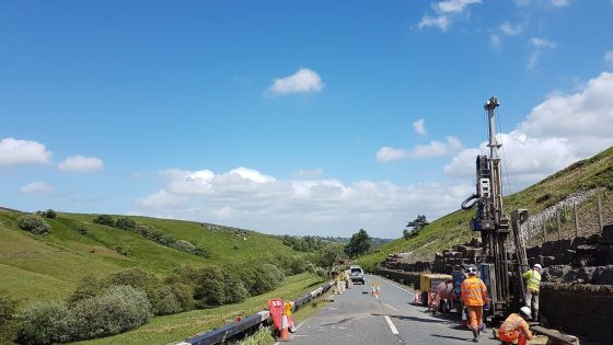
Mandatory sharing of ground investigation data under the proposed Geotechnical Data Sharing Bill is “critical” to cutting project cost and risk, AtkinsRéalis geotechnical engineer and Engineering Geology chair Dr Jacqueline Skipper told NCE. Skipper argues that making borehole logs, in situ test results and laboratory data publicly accessible would reduce duplicated site investigations, improve desk studies and help identify legacy hazards earlier in design. For contractors and consultants, she says the Bill could materially change tender pricing, contingency allowances and early-stage geotechnical risk allocation.
Technical Brief
- Standardised digital formats are implied, enabling direct import into ground models and GIS rather than PDF trawling.
- Earlier access to third-party CPT, pressuremeter and permeability data would tighten geotechnical design parameters and correlations.
- Consultants could reduce provisional sums for “unforeseen ground conditions” where dense historic coverage exists.
- Contractors may re-optimise piling, earthworks balance and temporary works once shared data confirms or refutes desk assumptions.
- For similar linear infrastructure corridors, cumulative shared datasets would progressively de-risk route-wide geotechnical zoning.
Our Take
AtkinsRéalis is increasingly embedded in UK public infrastructure delivery, with recent roles on the Midlands Rail Hub Alliance and Heathrow’s expansion programme, so a statutory framework for sharing ground investigation data would directly affect how it manages subsurface risk across multiple long‑term portfolios.
Our database shows AtkinsRéalis holding sole‑provider and framework positions with several local authorities, including a £96m highways contract with Herefordshire Council, meaning any mandated data‑sharing standard would likely be piloted and stress‑tested first on highways and local transport schemes rather than megaprojects.
Prepared by collating external sources, AI-assisted tools, and Geomechanics.io’s proprietary mining database, then reviewed for technical accuracy & edited by our geotechnical team.
Related Articles
Related Industries & Products
Mining
Geotechnical software solutions for mining operations including CMRR analysis, hydrogeological testing, and data management.
Construction
Quality control software for construction companies with material testing, batch tracking, and compliance management.
HYDROGEO-io
Comprehensive hydrogeological testing platform for managing, analysing, and reporting on packer tests, lugeon values, and hydraulic conductivity assessments.
GEODB-io
Centralised geotechnical data management solution for storing, accessing, and analysing all your site investigation and material testing data.