83% of Britain’s cities heat‑vulnerable: design implications for civil engineers
Reviewed by Joe Ashwell
First reported on New Civil Engineer
30 Second Briefing
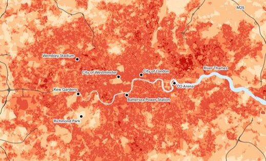
Eighty-three per cent of Britain’s cities – 59 urban areas – are classed as highly vulnerable to urban heat in new spatial analysis by Ordnance Survey, the Met Office and 4 Earth Intelligence. The dataset combines OS building footprints, surface cover and green space with Met Office temperature projections to map local heat exposure at street-block scale. For civil and geotechnical engineers, this points to urgent retrofit of shading, permeable and high-albedo surfaces, and revised pavement and rail design to cope with more frequent extreme surface temperatures.
Technical Brief
- Designers can target tree planting, shading structures and surface material changes to specific high-exposure blocks, not whole boroughs.
- Safety planning can prioritise cooling centres, shaded pedestrian routes and worker heat-stress controls in mapped hotspots.
- Dataset supports compliance reviews against workplace heat-stress guidance and emerging building overheating regulations.
- Scope is limited to Britain’s cities; rural settlements, villages and isolated infrastructure corridors are not characterised.
Our Take
Ordnance Survey’s urban heat work sits alongside its recent climate-driven flood risk mapping for England’s strategic roads and railways, signalling that OS and New Civil Engineer are increasingly framing climate hazards as an integrated infrastructure-planning problem rather than isolated events.
The OS Enhanced Land Cover (ELC) Beta habitat-mapping dataset referenced in our coverage gives local authorities in Britain a ready-made spatial layer to cross-check where high urban heat vulnerability overlaps with limited green or blue infrastructure, which is critical for targeting cooling interventions.
Prepared by collating external sources, AI-assisted tools, and Geomechanics.io’s proprietary mining database, then reviewed for technical accuracy & edited by our geotechnical team.
Related Articles
Related Industries & Products
Construction
Quality control software for construction companies with material testing, batch tracking, and compliance management.
Mining
Geotechnical software solutions for mining operations including CMRR analysis, hydrogeological testing, and data management.
CMRR-io
Streamline coal mine roof stability assessments with our cloud-based CMRR software featuring automated calculations, multi-scenario analysis, and collaborative workflows.
HYDROGEO-io
Comprehensive hydrogeological testing platform for managing, analysing, and reporting on packer tests, lugeon values, and hydraulic conductivity assessments.
GEODB-io
Centralised geotechnical data management solution for storing, accessing, and analysing all your site investigation and material testing data.