Geomechanics.io

  • Free Tools
Sign UpLog In

    Geomechanics.io

    Geomechanics, Streamlined.

    © 2026 Geomechanics.io. All rights reserved.

    Geomechanics.io

    CMRR-ioGEODB-ioHYDROGEO-ioQCDB-ioFree Tools & CalculatorsBlogLatest Industry News

    Industries

    MiningConstructionTunnelling

    Company

    Terms of UsePrivacy PolicyLinkedIn
    Projects
    Product

    OpenGround Civil 3D Extension: live geotechnical models for civil designers

    July 2, 2026|

    Reviewed by Tom Sullivan

    OpenGround Civil 3D Extension: live geotechnical models for civil designers

    First reported on Geoengineer.org – News

    30 Second Briefing

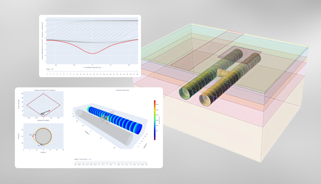
    Seequent’s OpenGround Civil 3D Extension links live geotechnical data from OpenGround into Autodesk Civil 3D, allowing borehole logs, interpreted strata and lab test results to update directly within corridor, grading and earthworks models. Designers can generate 3D ground models, cross-sections and surfaces that automatically reflect new investigations, rather than relying on static AGS or CSV imports. The workflow reduces manual rework and helps geotechnical and civil teams keep alignments, cut/fill volumes and foundation layouts consistent with the latest ground model.

    Technical Brief

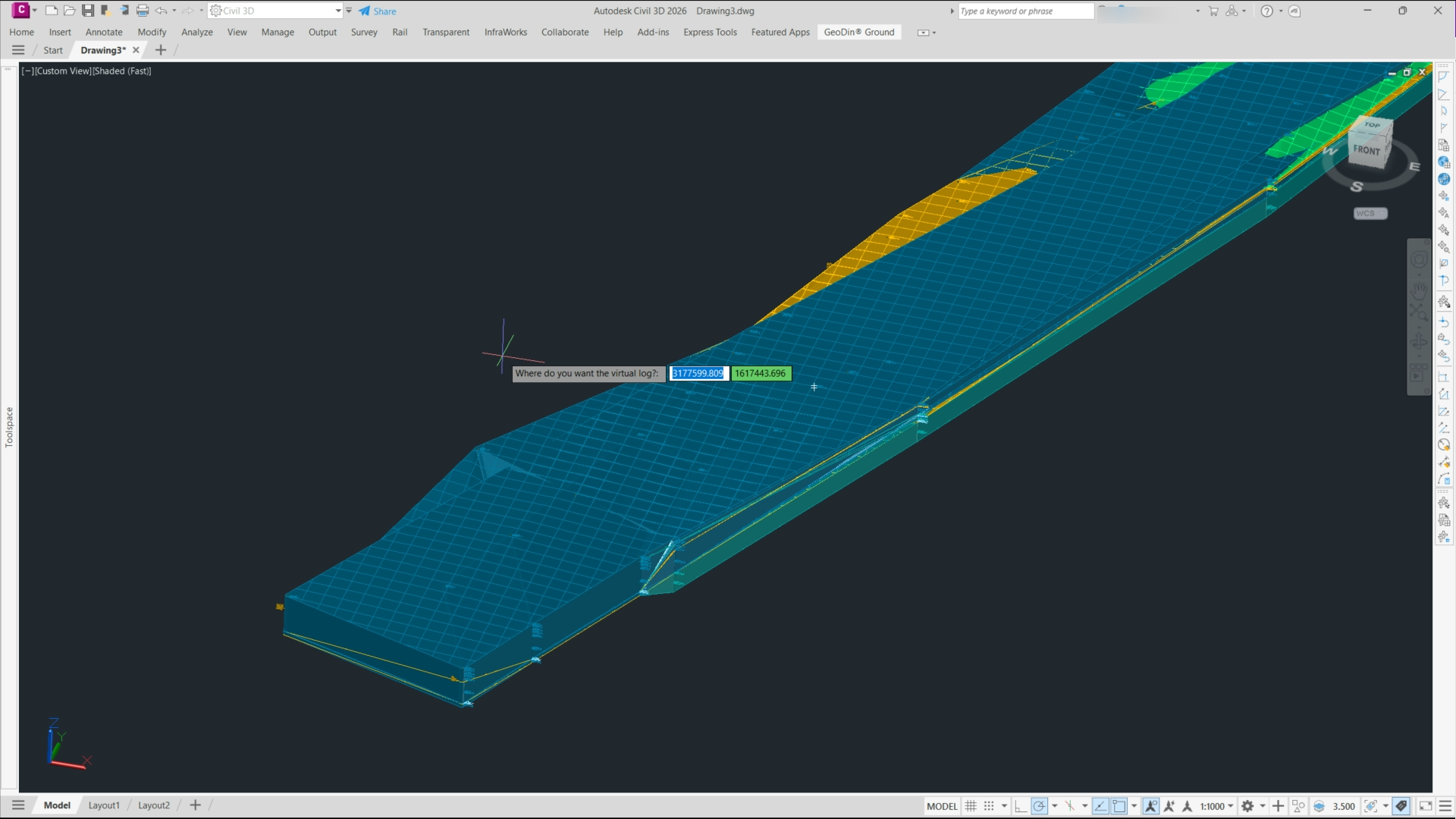
    • Extension installs directly into Autodesk Civil 3D as an add-on, using native Civil 3D objects.
    • Borehole locations are driven from OpenGround coordinates, avoiding manual re-keying of chainages and offsets.
    • Users can filter imported investigations by project, location group, depth range or date of drilling.
    • Log styles, symbols and colours are controlled by OpenGround configuration, enforcing corporate standards across drawings.
    • Interpreted strata from OpenGround are mapped to Civil 3D surfaces via user-defined geology codes and layers.
    • Lab test tables (e.g. strength, consolidation, PSD) are queryable within Civil 3D using OpenGround field names.
    • Data remains read-only in Civil 3D; edits to geology or tests must be made in OpenGround.
    • For multi-contract programmes, a single OpenGround project can feed multiple Civil 3D models with consistent ground data.

    Our Take

    Seequent’s push to make OpenGround data usable directly in Civil 3D lines up with its recent addition of lab-testing workflows to OpenGround (Feb 2026), signalling a move towards a single subsurface data spine feeding both design and reporting tools.

    The 7th Geoprofessionals Data Management Report (Jan 2026) found geoprofessionals spending over 25% of their time on data management; tighter Civil 3D–OpenGround integration is likely aimed at clawing back that time by reducing manual transfer and re‑interpretation of ground models in civil design workflows.

    Geotechnical Software for Modern Teams

    Centralise site data, logs, and lab results with GEODB-io, CMRR-io, and HYDROGEO-io.

    No credit card required.

    • Save and export unlimited calculations
    • Advanced data visualisation
    • Generate professional PDF reports
    • Cloud storage for all your projects

    Prepared by collating external sources, AI-assisted tools, and Geomechanics.io’s proprietary mining database, then reviewed for technical accuracy & edited by our geotechnical team.

    Related Articles

    Scripting in RS3: tunnel liner design envelopes and checks for engineers
    Software
    1 day ago

    Scripting in RS3: tunnel liner design envelopes and checks for engineers

    Scripting in RS3 now lets tunnel designers automatically extract lining forces, moments, and displacements at every section along a 3D model, instead of manually interrogating individual cross-sections. Users can generate full lining design envelopes, export results to spreadsheets or custom reports, and rapidly iterate on reinforcement or segment thickness without re-running the finite element analysis. For geotechnical teams, this shifts effort from repetitive post-processing to checking design assumptions, load cases, and ground–structure interaction behaviour across the entire tunnel.

    GeoDin Ground for Civil 3D: subsurface modelling in practice for designers
    Software
    1 day ago

    GeoDin Ground for Civil 3D: subsurface modelling in practice for designers

    GeoDin Ground, a free Autodesk Civil 3D plug-in, replaces manual borehole imports by directly linking Civil 3D models to GeoDin® geotechnical databases and AGS/Excel borehole logs. The tool generates dynamic 3D subsurface models, including stratigraphy, groundwater levels and geotechnical layers, that update automatically as borehole data change. For designers, this means borehole positions, interpreted soil horizons and material properties are embedded in corridors, alignments and earthworks, reducing data re-entry and improving consistency between geotechnical interpretation and Civil 3D design.

    AASB S2 climate reporting: Envago implementation notes for mine operators
    Software
    21 days ago

    AASB S2 climate reporting: Envago implementation notes for mine operators

    Greenbase’s Envago platform is being deployed to help mining companies comply with Australia’s new mandatory climate reporting regime under AASB S2, which requires disclosure of climate-related risks, Scope 1–3 emissions and governance alongside financial statements. Envago replaces spreadsheet-based workflows by integrating data from site operations, energy meters and procurement systems into a single emissions and ESG reporting environment. For mine operators, this means earlier alignment with AASB S2 assurance expectations and reduced manual reconciliation effort across multiple assets and joint ventures.

    Related Industries & Products

    Construction

    Quality control software for construction companies with material testing, batch tracking, and compliance management.

    Mining

    Geotechnical software solutions for mining operations including CMRR analysis, hydrogeological testing, and data management.

    GEODB-io

    Centralised geotechnical data management solution for storing, accessing, and analysing all your site investigation and material testing data.

    AllGeotechnicalMiningInfrastructureMaterialsHazardsEnvironmentalSoftwarePolicy