Geomechanics.io

  • Free Tools
Sign UpLog In

Geomechanics.io

Geomechanics, Streamlined.

© 2026 Geomechanics.io. All rights reserved.

Geomechanics.io

CMRR-ioGEODB-ioHYDROGEO-ioQCDB-ioFree Tools & CalculatorsBlogLatest Industry News

Industries

MiningConstructionTunnelling

Company

Terms of UsePrivacy PolicyLinkedIn
    AllGeotechnicalMiningInfrastructureMaterialsHazardsEnvironmentalSoftwarePolicy
    Op-Ed
    Sustainability
    Projects

    Managed aquifer recharge for UK floods and droughts: design notes for engineers

    March 13, 2026|

    Reviewed by Joe Ashwell

    Managed aquifer recharge for UK floods and droughts: design notes for engineers

    First reported on New Civil Engineer

    30 Second Briefing

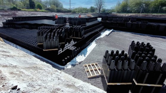
    Stormwater engineer David Schofield argues that large-scale managed aquifer recharge (MAR) using infiltration basins and recharge wells could simultaneously reduce UK surface-water flood peaks and bolster drought resilience. He points to schemes where storm flows are diverted from combined sewers into gravel-filled soakaways and deep injection wells, storing millions of cubic metres in permeable chalk and sandstone rather than building ever-larger attenuation tanks. For geotechnical and civil designers, MAR shifts focus towards subsurface storage capacity, soil permeability, groundwater mounding, and long-term water quality monitoring.

    Technical Brief

    • Managed aquifer recharge is framed as an alternative to escalating hard-defence schemes and river channelisation.
    • The op-ed flags potential clogging of infiltration structures by urban sediments, implying ongoing maintenance and pretreatment.
    • Water quality risks focus on hydrocarbons, metals and pathogens mobilised from urban runoff entering potable aquifers.

    Geotechnical Software for Modern Teams

    Centralise site data, logs, and lab results with GEODB-io, CMRR-io, and HYDROGEO-io.

    No credit card required.

    • Save and export unlimited calculations
    • Advanced data visualisation
    • Generate professional PDF reports
    • Cloud storage for all your projects

    Prepared by collating external sources, AI-assisted tools, and Geomechanics.io’s proprietary mining database, then reviewed for technical accuracy & edited by our geotechnical team.

    Related Articles

    Anglo American Bowen Basin eDNA: habitat data and rehab design notes for engineers
    Environmental
    10 days ago

    Anglo American Bowen Basin eDNA: habitat data and rehab design notes for engineers

    Anglo American is deploying environmental DNA (eDNA) sampling across its Bowen Basin coal operations, including Capcoal, to verify fauna using rehabilitated waste dumps and tailings areas. Environment teams collect air, water and soil samples to detect species such as microbats, small mammals and birds moving through reshaped and revegetated landforms, complementing traditional trapping and camera surveys. The approach gives mine planners finer-grained data on habitat use and succession, informing design of final landforms, drainage lines and vegetation communities for progressive rehabilitation sign-off.

    Environment Agency drone squad: LiDAR enforcement lessons for waste engineers
    Environmental
    24 days ago

    Environment Agency drone squad: LiDAR enforcement lessons for waste engineers

    Environment Agency drones are being deployed more aggressively against organised fly-tipping, with a 33-strong pilot squad logging 272 flight hours since July and preparing to carry light detection and ranging (LiDAR) payloads for high-resolution volumetric mapping of illegal waste sites. Moving LiDAR from manned aircraft to UAVs is intended to give prosecutors precise 3D evidence of waste locations and extents, while a new screening tool cross-checks lorry licence applications against waste permit records to flag suspect operators. Enforcement capacity has been boosted with the joint waste crime unit expanded from 13 to 20 staff, supporting 751 illegal sites shut and 221 prosecutions since March 2025 under a £15.6m enforcement budget.

    Hinkley Point C acoustic fish deterrent: design and permitting lessons for engineers
    Environmental
    about 1 month ago

    Hinkley Point C acoustic fish deterrent: design and permitting lessons for engineers

    An ultrasonic acoustic fish deterrent designed for EDF’s Hinkley Point C cooling water intakes has proved “highly effective” in Swansea University trials, significantly reducing fish approach rates to the intake zone. The system uses targeted sound frequencies to steer multiple species away from the intake channel, aiming to meet Environment Agency requirements on impingement and entrainment without major changes to the intake structure. Trial results may remove the need for a large compensatory saltmarsh scheme on the Severn Estuary, easing local planning and coastal engineering constraints.

    Related Industries & Products

    Construction

    Quality control software for construction companies with material testing, batch tracking, and compliance management.

    CMRR-io

    Streamline coal mine roof stability assessments with our cloud-based CMRR software featuring automated calculations, multi-scenario analysis, and collaborative workflows.

    HYDROGEO-io

    Comprehensive hydrogeological testing platform for managing, analysing, and reporting on packer tests, lugeon values, and hydraulic conductivity assessments.

    GEODB-io

    Centralised geotechnical data management solution for storing, accessing, and analysing all your site investigation and material testing data.