Geomechanics.io

  • Free Tools
Sign UpLog In

Geomechanics.io

Geomechanics, Streamlined.

© 2026 Geomechanics.io. All rights reserved.

Geomechanics.io

CMRR-ioGEODB-ioHYDROGEO-ioQCDB-ioFree Tools & CalculatorsBlogLatest Industry News

Industries

MiningConstructionTunnelling

Company

Terms of UsePrivacy PolicyLinkedIn
    Projects
    Safety
    Sustainability

    Long Baseline Neutrino Facility caverns: geotechnical design notes for engineers

    March 19, 2026|

    Reviewed by Joe Ashwell

    Long Baseline Neutrino Facility caverns: geotechnical design notes for engineers

    First reported on New Civil Engineer

    30 Second Briefing

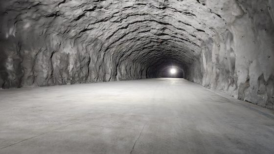
    Excavation is under way 1.5km below ground at the Long Baseline Neutrino Facility in South Dakota to create three caverns, each roughly cathedral-sized, to house the Deep Underground Neutrino Experiment’s liquid-argon detectors. The 1,300km-long beamline from Fermilab to the former Homestake gold mine demands tight control of rock mass behaviour, with extensive pre-grouting, cable bolting and shotcrete linings in complex, stressed Precambrian formations. Construction sequencing, spoil handling through deep shafts and long-term groundwater management are central geotechnical risks for the multi-year programme.

    Technical Brief

    • Rock support design is governed by long-term detector stability requirements, with very tight deformation tolerances.
    • Construction safety planning includes blast vibration limits to protect existing underground infrastructure and sensitive scientific equipment.
    • Lessons on deep excavation safety management are expected to inform future large caverns for nuclear and data facilities.

    Our Take

    Safety-tagged items in our coverage usually concern operational mines or transport tunnels, so the Deep Underground Neutrino Experiment adds a less common angle: long-term geotechnical stability for ultra-sensitive scientific equipment, where even micro-seismicity and minor convergence become performance, not just safety, constraints.

    With no commodity or country attached in the article facts, LBNF/Dune stands out in the Projects and Sustainability tags as a rare example where deep excavation is justified purely by scientific and environmental knowledge goals, which can influence how regulators and local stakeholders weigh risk versus benefit compared with resource-extraction caverns.

    Geotechnical Software for Modern Teams

    Centralise site data, logs, and lab results with GEODB-io, CMRR-io, and HYDROGEO-io.

    No credit card required.

    • Save and export unlimited calculations
    • Advanced data visualisation
    • Generate professional PDF reports
    • Cloud storage for all your projects

    Prepared by collating external sources, AI-assisted tools, and Geomechanics.io’s proprietary mining database, then reviewed for technical accuracy & edited by our geotechnical team.

    Related Articles

    Mitchells Causeway NSW road fix: geotechnical design notes for ground engineers
    Geotechnical
    4 days ago

    Mitchells Causeway NSW road fix: geotechnical design notes for ground engineers

    Two engineering consortia have been shortlisted by the New South Wales Government to design and deliver a fix for Mitchells Causeway on the Great Western Highway at Victoria Pass, closed since March after substantial cracking and ground movement were detected. The move follows an industry briefing and on-site inspection involving 20 Australian and international firms, signalling complex geotechnical and structural stabilisation requirements on this steep Blue Mountains section. Outcomes will directly affect detour durations, heavy vehicle access and long-term slope and pavement performance on this key freight and commuter corridor.

    Mexico City’s sinking crisis mapped by NISAR: geotechnical design notes for engineers
    Geotechnical
    10 days ago

    Mexico City’s sinking crisis mapped by NISAR: geotechnical design notes for engineers

    Mexico City’s subsidence has been mapped in new detail by the NASA–ISRO NISAR L-band radar mission, revealing metropolitan zones sinking by more than 50cm per year over clay-rich former lakebed deposits. Interferometric SAR time-series show differential settlement across key infrastructure corridors, with some districts exhibiting cumulative subsidence of several metres over recent decades, far exceeding typical building serviceability limits. The data set offers geotechnical engineers block-scale deformation rates to refine foundation design, tunnel and metro monitoring, and groundwater extraction management.

    Brownfield success: integrated ground data workflows for project teams
    Geotechnical
    12 days ago

    Brownfield success: integrated ground data workflows for project teams

    Brownfield infrastructure projects are seeing geotechnical and environmental teams urged to integrate ground investigation, contamination data and 3D ground models from the outset, rather than running parallel site characterisation workflows. The piece stresses unified digital datasets combining borehole logs, in situ test results and contaminant plumes to refine ground risk registers, optimise foundation and earthworks design, and avoid late-stage remediation surprises. Case experience shows that early joint modelling of variable made ground, buried obstructions and legacy industrial pollution can materially cut unforeseen ground conditions claims and programme delays.

    Related Industries & Products

    Construction

    Quality control software for construction companies with material testing, batch tracking, and compliance management.

    Tunnelling

    Specialised solutions for tunnelling projects including grout mix design, hydrogeological analysis, and quality control.

    QCDB-io

    Comprehensive quality control database for manufacturing, tunnelling, and civil construction with UCS testing, PSD analysis, and grout mix design management.

    AllGeotechnicalInfrastructureHazardsEnvironmental