Geomechanics.io

  • Free Tools
Sign UpLog In

Geomechanics.io

Geomechanics, Streamlined.

© 2026 Geomechanics.io. All rights reserved.

Geomechanics.io

CMRR-ioGEODB-ioHYDROGEO-ioQCDB-ioFree Tools & CalculatorsBlogLatest Industry News

Industries

MiningConstructionTunnelling

Company

Terms of UsePrivacy PolicyLinkedIn
    Projects
    Research

    Mexico City’s sinking crisis mapped by NISAR: geotechnical design notes for engineers

    May 13, 2026|

    Reviewed by Joe Ashwell

    Mexico City’s sinking crisis mapped by NISAR: geotechnical design notes for engineers

    First reported on Geoengineer.org – News

    30 Second Briefing

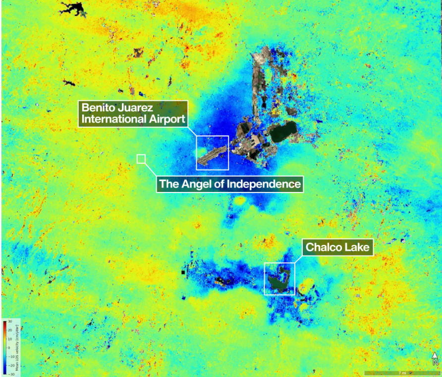
    Mexico City’s subsidence has been mapped in new detail by the NASA–ISRO NISAR L-band radar mission, revealing metropolitan zones sinking by more than 50cm per year over clay-rich former lakebed deposits. Interferometric SAR time-series show differential settlement across key infrastructure corridors, with some districts exhibiting cumulative subsidence of several metres over recent decades, far exceeding typical building serviceability limits. The data set offers geotechnical engineers block-scale deformation rates to refine foundation design, tunnel and metro monitoring, and groundwater extraction management.

    Technical Brief

    • For design and asset management, datasets allow corridor-scale prioritisation of retrofits, re-levelling and groundwater pumping controls.
    • Coverage is limited to NISAR’s acquisition swath and revisit schedule, so small-scale or very rapid failures may be under-resolved.

    Our Take

    For Mexico City, a subsidence ‘Failure’ context means NISAR data can be directly integrated into foundation design checks and sewer/water network renewal planning, allowing engineers to prioritise corridors where differential settlement rates threaten buried infrastructure and elevated transport structures.

    Because NISAR is designed for routine, global coverage rather than project-by-project tasking, municipalities and utilities in Mexico and other high-risk basins can treat it as a baseline deformation layer, reducing reliance on sparse levelling surveys and giving insurers and regulators a common reference for ground-movement risk.

    Geotechnical Software for Modern Teams

    Centralise site data, logs, and lab results with GEODB-io, CMRR-io, and HYDROGEO-io.

    No credit card required.

    • Save and export unlimited calculations
    • Advanced data visualisation
    • Generate professional PDF reports
    • Cloud storage for all your projects

    Prepared by collating external sources, AI-assisted tools, and Geomechanics.io’s proprietary mining database, then reviewed for technical accuracy & edited by our geotechnical team.

    Related Articles

    BGS 11% UK subsidence forecast by 2070: design and risk notes for engineers
    Geotechnical
    8 days ago

    BGS 11% UK subsidence forecast by 2070: design and risk notes for engineers

    New climate-modelling by the British Geological Survey (BGS) projects that up to 11% of UK homes – several million properties – could face increased clay-related subsidence risk by 2070 as hotter, drier summers drive greater soil shrink–swell. The work uses UKCP18 climate scenarios to map susceptibility on shrink–swell clays, flagging particular exposure in southern and eastern England where high-plasticity London Clay and similar formations are widespread. For geotechnical and asset engineers, this points to tighter foundation design, tree and drainage management, and targeted monitoring of existing low-rise housing stock.

    Professor Lyesse Laloui as ISSMGE President: priorities and signals for geotechnical engineers
    Geotechnical
    12 days ago

    Professor Lyesse Laloui as ISSMGE President: priorities and signals for geotechnical engineers

    Professor Lyesse Laloui has been elected President of the International Society for Soil Mechanics and Geotechnical Engineering (ISSMGE) for 2026–2029 at the Vienna Council Meeting held alongside the XXI ICSMGE 2026. Laloui, Chair Professor at EPFL and director of its Laboratory for Soil Mechanics, brings a portfolio of more than 560 publications and 19,000+ citations spanning constitutive modelling, energy geostructures, CO₂ storage and multiphase porous media. The Council also confirmed XXII ICSMGE for Shanghai in November 2029 and the next Council Meeting in Istanbul, 20–25 August 2028.

    Levee Digital Twin Platform for Yuba River: condition monitoring insights for engineers
    Geotechnical
    16 days ago

    Levee Digital Twin Platform for Yuba River: condition monitoring insights for engineers

    Researchers at UC Berkeley, funded by Yuba Water, have launched a Levee Digital Twin Platform for the Yuba River corridor, integrating continuous sensor data, geotechnical models and inspection records into an interactive system for levee condition assessment. The platform combines real-time pore pressure and deformation monitoring with historical performance data to flag anomalous behaviour along specific reaches and embankment sections. Engineers can use the tool to prioritise field investigations, refine seepage and stability analyses, and plan targeted remediation before high-flow events.

    Related Industries & Products

    Construction

    Quality control software for construction companies with material testing, batch tracking, and compliance management.

    Mining

    Geotechnical software solutions for mining operations including CMRR analysis, hydrogeological testing, and data management.

    CMRR-io

    Streamline coal mine roof stability assessments with our cloud-based CMRR software featuring automated calculations, multi-scenario analysis, and collaborative workflows.

    HYDROGEO-io

    Comprehensive hydrogeological testing platform for managing, analysing, and reporting on packer tests, lugeon values, and hydraulic conductivity assessments.

    GEODB-io

    Centralised geotechnical data management solution for storing, accessing, and analysing all your site investigation and material testing data.

    AllGeotechnicalMiningInfrastructureMaterialsHazardsEnvironmentalSoftwarePolicy