Geomechanics.io

  • Free Tools
Sign UpLog In

Geomechanics.io

Geomechanics, Streamlined.

© 2026 Geomechanics.io. All rights reserved.

Geomechanics.io

CMRR-ioGEODB-ioHYDROGEO-ioQCDB-ioFree Tools & CalculatorsBlogLatest Industry News

Industries

MiningConstructionTunnelling

Company

Terms of UsePrivacy PolicyLinkedIn
    Op-Ed
    Projects
    Safety

    Ayesa 3D ground modelling for tunnelling: practice and training lessons for engineers

    February 25, 2026|

    Reviewed by Tom Sullivan

    Ayesa 3D ground modelling for tunnelling: practice and training lessons for engineers

    First reported on New Civil Engineer

    30 Second Briefing

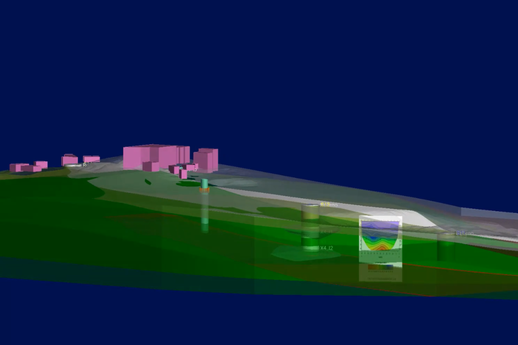
    Ayesa head of ground engineering and tunnelling Cláudio Cabral Dias is pushing wider adoption of subsurface 3D ground modelling to de‑risk next‑generation tunnelling, but warns that success depends on structured retraining rather than simply buying new software. He points to integrated 3D geological models that combine borehole logs, geophysics and historical excavation data to predict fault zones and variable rock mass behaviour ahead of TBM drives. Dias stresses that design teams, site engineers and contractors must all learn to interrogate and update these models in real time if they are to influence alignment, support classes and construction sequencing.

    Technical Brief

    • Subsurface 3D mapping is framed as a safety‑critical design tool, not just visualisation output.
    • Dias stresses that without structured retraining, engineers misinterpret 3D ground models, creating new safety risks.
    • He argues for formal workflows defining who updates models, when, and under which site triggers.
    • Data governance is highlighted: consistent coding of logs and geophysics is needed to avoid unsafe model artefacts.
    • Safety culture is expected to shift from static ground assumptions to continuously revised subsurface risk registers.
    • Contractors are urged to embed 3D model interrogation into method statements and temporary works checks.
    • Dias links model literacy to incident prevention, especially where TBM drives intersect poorly constrained faulted ground.
    • Wider implication: clients may begin specifying 3D ground modelling competence as a pre‑qualification safety requirement.

    Our Take

    Ayesa’s role on HS2 Track Systems Lots 1–3, as noted in our coverage of the Ayesa–Egis JV, suggests its 3D ground modelling tools are already being exercised on some of the UK’s most complex rail tunnelling interfaces, giving the software a high-stress proving ground.

    Within the 33 Software stories in our database, Ayesa is one of the few engineering consultancies appearing both as a digital tools proponent and as a delivery-side designer, which typically allows faster feedback loops between site experience and software feature development.

    For tunnelling-focused safety work, our tag-matched pieces show far more attention on construction methods than on pre-construction modelling, so Ayesa’s emphasis on 3D ground models signals a shift towards moving risk controls upstream into design and planning rather than relying mainly on procedural controls on site.

    Geotechnical Software for Modern Teams

    Centralise site data, logs, and lab results with GEODB-io, CMRR-io, and HYDROGEO-io.

    No credit card required.

    • Save and export unlimited calculations
    • Advanced data visualisation
    • Generate professional PDF reports
    • Cloud storage for all your projects

    Prepared by collating external sources, AI-assisted tools, and Geomechanics.io’s proprietary mining database, then reviewed for technical accuracy & edited by our geotechnical team.

    Related Articles

    Fluke SmartTrace cable spotter: reducing UK utility strike risk for project teams
    Software
    1 day ago

    Fluke SmartTrace cable spotter: reducing UK utility strike risk for project teams

    Fluke has launched the SmartTrace 2082 Series underground locator, which injects signals to trace metallic cables and pipelines down to 6 m depth while identifying ground faults, sheath faults and coating defects where conductors contact earth. The locator connects via Bluetooth to Fluke’s PointMan app, enabling real-time geolocation, mapping and documentation of buried utilities directly on a smartphone for future works planning. Fluke cites around 60,000 utility strikes per year in UK excavations, positioning SmartTrace as a tool to cut strike risk and improve pre-dig surveys.

    World Day for Safety and Health at Work: digital hazard tools for project engineers
    Software
    2 days ago

    World Day for Safety and Health at Work: digital hazard tools for project engineers

    World Day for Safety and Health at Work sees Mott MacDonald showcase five digital tools from a Strategic Design Partnership hackathon aimed at tightening hazard management on infrastructure projects. Concepts include automated hazard identification from design models, mobile apps for site-based risk reporting, and dashboards aggregating incident and near-miss data in real time. For civil and geotechnical teams, the focus is on earlier visibility of construction and ground risks, faster feedback loops between site and design, and more structured capture of lessons learned.

    OS Enhanced Land Cover for BNG: key mapping takeaways for project teams
    Software
    8 days ago

    OS Enhanced Land Cover for BNG: key mapping takeaways for project teams

    Ordnance Survey has launched OS Enhanced Land Cover (ELC) Beta, a national habitat-mapping dataset that fuses OS National Geographic Database topography, OS aerial imagery, OS Terrain 5 and third-party sources including Natural England’s Living England, the Rural Payments Agency’s Crop Map of England and UKHab classifications to support 10% Biodiversity Net Gain (BNG) assessments. The tool enables desktop and field workflows for ecologists and developers, with Wessex Water using it via Linckia’s ESRI-based Habitat Fabric platform to assess hundreds of sites in a single spatial view. Linckia reports a 40% cut in data processing costs versus previous methods, rising to 90% compared with processing raw imagery, with OS claiming time savings of days to weeks per development across 1.5 million homes in the pipeline.

    Related Industries & Products

    Tunnelling

    Specialised solutions for tunnelling projects including grout mix design, hydrogeological analysis, and quality control.

    Construction

    Quality control software for construction companies with material testing, batch tracking, and compliance management.

    QCDB-io

    Comprehensive quality control database for manufacturing, tunnelling, and civil construction with UCS testing, PSD analysis, and grout mix design management.

    AllGeotechnicalInfrastructureHazardsEnvironmental