Geomechanics.io

  • Free Tools
Sign UpLog In
AllGeotechnicalMiningInfrastructureMaterialsHazardsEnvironmentalSoftwarePolicy

Geomechanics.io

Geomechanics, Streamlined.

© 2026 Geomechanics.io. All rights reserved.

Geomechanics.io

CMRR-ioGEODB-ioHYDROGEO-ioQCDB-ioFree Tools & CalculatorsBlogLatest Industry News

Industries

MiningConstructionTunnelling

Company

Terms of UsePrivacy PolicyLinkedIn
    Projects
    Sustainability

    Anglo American Bowen Basin eDNA: habitat data and rehab design notes for engineers

    March 5, 2026|

    Reviewed by Joe Ashwell

    Anglo American Bowen Basin eDNA: habitat data and rehab design notes for engineers

    First reported on Australian Mining

    30 Second Briefing

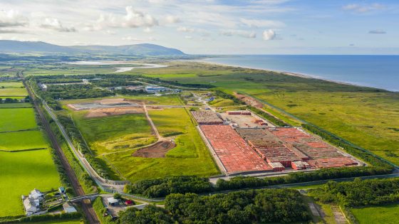
    Anglo American is deploying environmental DNA (eDNA) sampling across its Bowen Basin coal operations, including Capcoal, to verify fauna using rehabilitated waste dumps and tailings areas. Environment teams collect air, water and soil samples to detect species such as microbats, small mammals and birds moving through reshaped and revegetated landforms, complementing traditional trapping and camera surveys. The approach gives mine planners finer-grained data on habitat use and succession, informing design of final landforms, drainage lines and vegetation communities for progressive rehabilitation sign-off.

    Technical Brief

    • Airborne DNA sampling is undertaken using pumps and filters to capture shed skin, fur and faecal particles.
    • Water samples from drainage lines and pit lakes are filtered on-site, then preserved for laboratory metabarcoding.
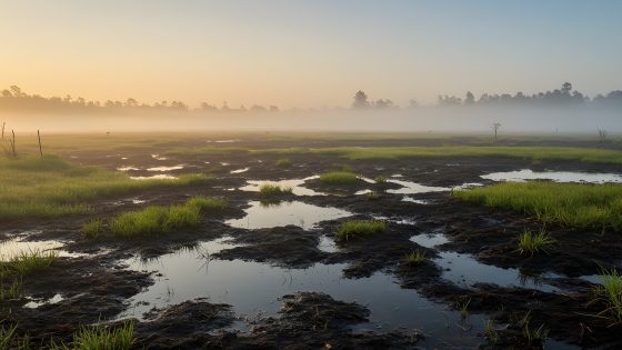
    • Soil cores are collected from rehabilitated profiles, targeting litter layers and topsoil horizons where DNA persists longest.
    • Laboratory analysis uses high-throughput sequencing against regional reference libraries to assign taxa from mixed DNA traces.
    • Results are spatially mapped over reshaped dumps and tailings surfaces to compare fauna use between rehabilitation ages.
    • Data are integrated with existing ecological monitoring datasets to refine completion criteria for progressive rehabilitation sign-off.
    • Similar eDNA workflows could be adopted at other coal mines to validate habitat function on constructed landforms.

    Our Take

    Within the 12 Environmental stories in our database, Anglo American features disproportionately in Australia-focused rehabilitation and sustainability pieces, signalling that its Bowen Basin work is being used as a flagship for its global ESG positioning.

    Bowen Basin rehabilitation is closely watched in our coverage because the basin hosts multiple long-life coal operations; successful post-mining land-use outcomes here tend to be referenced as benchmarks when regulators and communities assess new project approvals in Queensland.

    With 2059 tag-matched pieces under Projects and Sustainability, nature-based and data-heavy rehabilitation approaches at Australian coal sites like Bowen Basin are emerging as a practical way for operators to demonstrate progressive closure performance without committing to early mine shutdowns.

    Geotechnical Software for Modern Teams

    Centralise site data, logs, and lab results with GEODB-io, CMRR-io, and HYDROGEO-io.

    No credit card required.

    • Save and export unlimited calculations
    • Advanced data visualisation
    • Generate professional PDF reports
    • Cloud storage for all your projects

    Prepared by collating external sources, AI-assisted tools, and Geomechanics.io’s proprietary mining database, then reviewed for technical accuracy & edited by our geotechnical team.

    Related Articles

    Environment Agency drone squad: LiDAR enforcement lessons for waste engineers
    Environmental
    14 days ago

    Environment Agency drone squad: LiDAR enforcement lessons for waste engineers

    Environment Agency drones are being deployed more aggressively against organised fly-tipping, with a 33-strong pilot squad logging 272 flight hours since July and preparing to carry light detection and ranging (LiDAR) payloads for high-resolution volumetric mapping of illegal waste sites. Moving LiDAR from manned aircraft to UAVs is intended to give prosecutors precise 3D evidence of waste locations and extents, while a new screening tool cross-checks lorry licence applications against waste permit records to flag suspect operators. Enforcement capacity has been boosted with the joint waste crime unit expanded from 13 to 20 staff, supporting 751 illegal sites shut and 221 prosecutions since March 2025 under a £15.6m enforcement budget.

    Hinkley Point C acoustic fish deterrent: design and permitting lessons for engineers
    Environmental
    24 days ago

    Hinkley Point C acoustic fish deterrent: design and permitting lessons for engineers

    An ultrasonic acoustic fish deterrent designed for EDF’s Hinkley Point C cooling water intakes has proved “highly effective” in Swansea University trials, significantly reducing fish approach rates to the intake zone. The system uses targeted sound frequencies to steer multiple species away from the intake channel, aiming to meet Environment Agency requirements on impingement and entrainment without major changes to the intake structure. Trial results may remove the need for a large compensatory saltmarsh scheme on the Severn Estuary, easing local planning and coastal engineering constraints.

    UK geothermal as mainstream heat: design and monitoring notes for engineers
    Environmental
    25 days ago

    UK geothermal as mainstream heat: design and monitoring notes for engineers

    Britain is being urged to treat deep and shallow geothermal as a mainstream heat source, with a new national roadmap arguing that the country’s substantial but underused subsurface resource could displace a significant share of gas‑fired heating. The plan points to proven concepts such as mine‑water geothermal in former coalfields and district heating from deep sedimentary aquifers, which can be integrated with existing heat networks and large heat pumps. For civil and geotechnical engineers, this signals growing demand for high‑temperature boreholes, well integrity design and long‑term monitoring of thermal–hydraulic behaviour in urban ground.

    Related Industries & Products

    Mining

    Geotechnical software solutions for mining operations including CMRR analysis, hydrogeological testing, and data management.

    CMRR-io

    Streamline coal mine roof stability assessments with our cloud-based CMRR software featuring automated calculations, multi-scenario analysis, and collaborative workflows.

    HYDROGEO-io

    Comprehensive hydrogeological testing platform for managing, analysing, and reporting on packer tests, lugeon values, and hydraulic conductivity assessments.

    GEODB-io

    Centralised geotechnical data management solution for storing, accessing, and analysing all your site investigation and material testing data.