Phillipsburg sinkholes and dump truck collapse: geotechnical lessons for engineers
Reviewed by Joe Ashwell

First reported on Geoengineer.org – News
30 Second Briefing
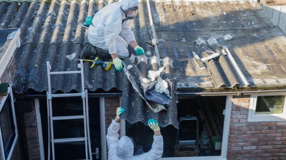
Multiple sinkholes along Summit Avenue near Lewis Street in Phillipsburg, New Jersey have triggered a local state of emergency after one collapse swallowed a loaded dump truck and undermined adjacent properties. Authorities have evacuated several homes, closed the affected road section, and are investigating suspected subsurface voids linked to ageing water or sewer infrastructure beneath the asphalt pavement. Geotechnical teams now face urgent stability assessment, utility leak detection, and staged backfilling or grouting in a constrained urban corridor with active buried services.
Technical Brief
- Dump truck collapse point provides a direct borehole location to log pavement, fill and native strata contacts.
- Forensic work will likely combine CCTV sewer inspection, water main pressure testing and GPR void mapping.
- Pavement distress patterns along Summit Avenue can be used to delineate the active subsidence corridor.
- Continuous vibration and load from construction traffic suggests cyclic degradation of any pre‑existing utility leaks.
- Emergency works will need staged, low‑mobility grout injection to avoid further undermining adjacent foundations.
- Short‑term monitoring should include daily crack mapping, settlement pins on kerbs, and utility flow/pressure logging.
- Incident underlines need for formalised sinkhole risk screening in older service corridors before heavy vehicle permitting.
Our Take
Among the 38 Hazards stories in our coverage, very few involve urban or roadside sinkhole failures in the United States, which signals that the Phillipsburg event in New Jersey is an outlier compared with the more typical tailings or highwall incidents.
For New Jersey projects, repeated sinkhole formation often points to legacy subsurface conditions—such as old utilities, fill, or karst features—that are not always fully captured in standard geotechnical investigations, suggesting local authorities may need more intrusive ground investigation and continuous monitoring along haul routes.
Within the 2083 tag-matched pieces on Projects, Failure and Safety, most roadway-related failures escalate into regulatory reviews of load limits and ground-penetrating surveys, so operators using heavy trucks in similar US towns should expect closer scrutiny of pavement design and subsurface stability near construction or waste sites.
Prepared by collating external sources, AI-assisted tools, and Geomechanics.io’s proprietary mining database, then reviewed for technical accuracy & edited by our geotechnical team.
Related Articles

Related Industries & Products
Construction
Quality control software for construction companies with material testing, batch tracking, and compliance management.
Mining
Geotechnical software solutions for mining operations including CMRR analysis, hydrogeological testing, and data management.
CMRR-io
Streamline coal mine roof stability assessments with our cloud-based CMRR software featuring automated calculations, multi-scenario analysis, and collaborative workflows.
HYDROGEO-io
Comprehensive hydrogeological testing platform for managing, analysing, and reporting on packer tests, lugeon values, and hydraulic conductivity assessments.
GEODB-io
Centralised geotechnical data management solution for storing, accessing, and analysing all your site investigation and material testing data.