Geomechanics.io

  • Free Tools
Sign UpLog In
Built byBoxcut Studio

Geomechanics.io

Geomechanics, Streamlined.

© 2026 Geomechanics.io. All rights reserved.

Geomechanics.io

CMRR-ioGEODB-ioHYDROGEO-ioQCDB-ioFree Tools & CalculatorsBlogLatest Industry News

Industries

MiningConstructionTunnelling

Company

Terms of UsePrivacy PolicyLinkedIn
    Projects
    Product

    RS3 scripting in Python: workflow and parametric analysis gains for engineers

    May 5, 2026|

    Reviewed by Joe Ashwell

    RS3 scripting in Python: workflow and parametric analysis gains for engineers

    First reported on Geoengineer.org – News

    30 Second Briefing

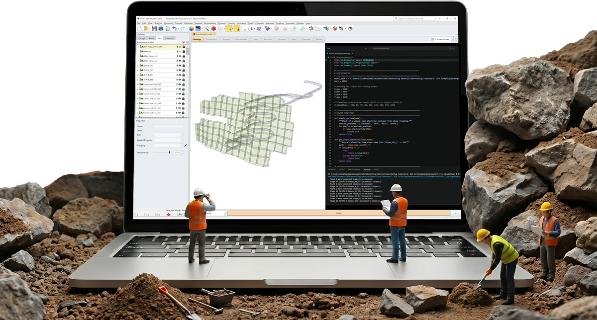
    Rocscience has added a Python-based scripting engine to its RS3 3D finite element software, allowing users to automate model creation, staged construction sequences, and parametric studies that previously required manual input. Engineers can now script geometry generation, material assignment, mesh refinement, and batch analyses, then extract results programmatically for hundreds of scenarios, cutting repetitive setup and post-processing time. The update targets large, complex models such as multi-stage excavations and tunnel–shaft systems where consistent workflows and rapid sensitivity checks are critical.

    Technical Brief

    • Engineers can script complex staged construction sequences, synchronising excavation, support installation and material activation events.
    • Scripting facilitates reproducible workflows for regulatory submissions, with a single code base defining all model variants.
    • For large 3D excavations and underground works, scripting aligns with industry movement towards fully scripted, version-controlled geotechnical models.

    Geotechnical Software for Modern Teams

    Centralise site data, logs, and lab results with GEODB-io, CMRR-io, and HYDROGEO-io.

    No credit card required.

    • Save and export unlimited calculations
    • Advanced data visualisation
    • Generate professional PDF reports
    • Cloud storage for all your projects

    Prepared by collating external sources, AI-assisted tools, and Geomechanics.io’s proprietary mining database, then reviewed for technical accuracy & edited by our geotechnical team.

    Related Articles

    Software
    1 day ago

    Acquire EnviroSys–GIM Suite integration: workflow and QA gains for mine teams

    Acquire Technology Solutions has linked its Envirosys 9.5 environmental compliance platform with its GIM Suite geological data management system, creating a single workflow for drill hole, monitoring and location records. Environmental teams can now pull borehole IDs, collar coordinates and monitoring point locations directly from GIM Suite into Envirosys, reducing manual duplication and reconciliation. For mine operators, this should cut reporting errors in groundwater, dust and discharge datasets that rely on accurate spatial and geological references.

    Alchera’s AI roadworks scheduling funding: network modelling insights for engineers
    Software
    1 day ago

    Alchera’s AI roadworks scheduling funding: network modelling insights for engineers

    Alchera has secured £2.7m in seed funding, including £2m led by Maven Capital Partners via the British Business Bank’s South West Investment Fund plus £700,000 from Innovate UK’s Investor Partnerships programme, to scale its AI platform for road operations and maintenance planning. The software ingests bus location, traffic signal, vehicle movement, weather and air quality data, using proprietary, patent-pending traffic modelling to cut transport analysis from weeks to seconds and provide 24‑month traffic flow forecasts for schemes such as M25 roadworks. In Lancashire it is already analysing over 300 junctions and 85,000 network links to diagnose bus performance issues and target investment.

    Hexagon–Rocscience deal: integrated modelling and monitoring for ground engineers
    Software
    3 days ago

    Hexagon–Rocscience deal: integrated modelling and monitoring for ground engineers

    Hexagon has acquired Toronto-based modelling specialist Rocscience, integrating its finite element and limit equilibrium tools for slope stability, tunnelling and dam analysis into Hexagon’s radar and monitoring division. The combined platform will link Hexagon’s continuous geotechnical sensors, including radar monitoring of ground movement, directly to Rocscience’s rock and soil behaviour models to auto‑update designs from construction through operations. For infrastructure and mining projects, this enables live calibration of stability models, earlier detection of deformation trends and shorter turnaround on ground‑risk assessments.

    Related Industries & Products

    Tunnelling

    Specialised solutions for tunnelling projects including grout mix design, hydrogeological analysis, and quality control.

    Construction

    Quality control software for construction companies with material testing, batch tracking, and compliance management.

    QCDB-io

    Comprehensive quality control database for manufacturing, tunnelling, and civil construction with UCS testing, PSD analysis, and grout mix design management.

    AllGeotechnicalInfrastructureHazardsEnvironmental