Geomechanics.io

  • Free Tools
Sign UpLog In

Geomechanics.io

Geomechanics, Streamlined.

© 2026 Geomechanics.io. All rights reserved.

Geomechanics.io

CMRR-ioGEODB-ioHYDROGEO-ioQCDB-ioFree Tools & CalculatorsBlogLatest Industry News

Industries

MiningConstructionTunnelling

Company

Terms of UsePrivacy PolicyLinkedIn
    Product
    Projects

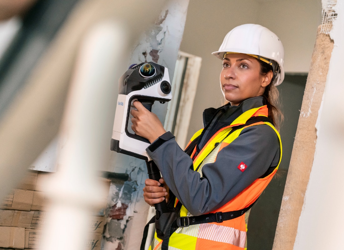
    NavVis CLX handheld capture: practical implications for mine and plant teams

    September 7, 2026|

    Reviewed by Joe Ashwell

    NavVis CLX handheld capture: practical implications for mine and plant teams

    First reported on Australian Mining

    30 Second Briefing

    NavVis has launched the NavVis CLX, an agile handheld reality capture device using dual LiDAR architecture to generate clean, low-noise point clouds for high-volume, day-to-day mine and plant documentation. Positioned to complement the backpack-style NavVis VLX and trolley-based NavVis MLX, the CLX is intended for frequent use by non-specialist staff, putting “professional reality capture in every hand”. For mining engineers and survey teams, this points to wider, lower-cost 3D documentation of underground drives, process plants and brownfield modifications without full survey campaigns.

    Technical Brief

    • Dual LiDAR architecture is configured to minimise occlusions and blind spots during rapid handheld sweeps.
    • Sensor fusion onboard is tuned to output low-noise point clouds suitable for as-built modelling workflows.
    • Device form factor is optimised for single-operator use in congested plant rooms and scaffolded areas.
    • CLX data is designed to integrate with existing NavVis processing pipelines used for MLX and VLX datasets.
    • Handheld configuration targets short mobilisation times, reducing setup compared with tripod or trolley-based scanners.
    • System is positioned for repetitive documentation passes, supporting change detection in active construction or retrofit zones.
    • Wider deployment to non-specialists implies revised QA workflows for scan coverage, registration accuracy and metadata management.

    Our Take

    For Australian projects, handheld capture like NavVis CLX typically reduces the need for repeat site access by design and engineering teams, which can materially cut travel and shutdown time compared with tripod-based scanning workflows.

    NavVis already appears in our coverage via its MLX and VLX systems, and adding CLX suggests the company is trying to cover both high-throughput trolley or backpack mapping and lighter, task-based documentation, giving mine operators more flexibility in how they digitise workings and plants.

    Geotechnical Software for Modern Teams

    Centralise site data, logs, and lab results with GEODB-io, CMRR-io, and HYDROGEO-io.

    No credit card required.

    • Save and export unlimited calculations
    • Advanced data visualisation
    • Generate professional PDF reports
    • Cloud storage for all your projects

    Prepared by collating external sources, AI-assisted tools, and Geomechanics.io’s proprietary mining database, then reviewed for technical accuracy & edited by our geotechnical team.

    Related Articles

    Workday AI Research: reliability and auditability notes for mining HR systems
    Software
    3 days ago

    Workday AI Research: reliability and auditability notes for mining HR systems

    Workday has launched Workday AI Research, a dedicated technical team to develop reliable, auditable AI models for enterprise HR, finance, and IT workflows used by mining and resources companies. The group will publish methods and evaluation frameworks for areas such as bias detection in workforce analytics, explainable decision support for rostering and payroll, and efficiency gains in large-scale ERP data processing. For mine operators, this signals more rigorous, research-backed AI tools embedded in core systems that govern labour planning, contractor management, and compliance reporting.

    Datamine leadership changes: workflow and interoperability takeaways for mine teams
    Software
    4 days ago

    Datamine leadership changes: workflow and interoperability takeaways for mine teams

    Datamine has appointed former KPMG and EY consultant Phil Ciezak as chief operating officer and long‑time mining software leader Anthony Cook as chief product officer to drive its integrated geology, planning and fleet management platforms. The move targets tighter linkage between Datamine’s mine planning, scheduling and ore control tools and its real‑time operational systems for drill‑and‑blast, haulage and processing. For engineers, this signals more emphasis on end‑to‑end data workflows, decision support and interoperability across existing Datamine deployments.

    Software
    6 days ago

    Deswik NOVA integrated surface mine planning: workflow takeaways for engineers

    Deswik, part of Sandvik Mining, has launched Deswik NOVA, an integrated surface mine planning platform that combines mining, blending and haulage in a single environment. The tool is aimed at data-intensive open pits where planners must rapidly test multiple scenarios, linking block models, stockpile balances and truck haulage routes without exporting between separate packages. For geotechnical and mining engineers, this promises tighter coupling between pit designs, material movement schedules and plant feed quality control, with fewer manual hand-offs and version risks.

    Related Industries & Products

    Mining

    Geotechnical software solutions for mining operations including CMRR analysis, hydrogeological testing, and data management.

    Construction

    Quality control software for construction companies with material testing, batch tracking, and compliance management.

    CMRR-io

    Streamline coal mine roof stability assessments with our cloud-based CMRR software featuring automated calculations, multi-scenario analysis, and collaborative workflows.

    GEODB-io

    Centralised geotechnical data management solution for storing, accessing, and analysing all your site investigation and material testing data.

    HYDROGEO-io

    Comprehensive hydrogeological testing platform for managing, analysing, and reporting on packer tests, lugeon values, and hydraulic conductivity assessments.

    AllGeotechnicalInfrastructureHazardsEnvironmental