Geomechanics.io

  • Free Tools
Sign UpLog In

    Geomechanics.io

    Geomechanics, Streamlined.

    © 2026 Geomechanics.io. All rights reserved.

    Geomechanics.io

    CMRR-ioGEODB-ioHYDROGEO-ioQCDB-ioFree Tools & CalculatorsBlogLatest Industry News

    Industries

    MiningConstructionTunnelling

    Company

    Terms of UsePrivacy PolicyLinkedIn
    Projects
    Safety

    Hull Heat Network dig: coordinating archaeology and trench design for engineers

    May 20, 2026|

    Reviewed by Joe Ashwell

    Hull Heat Network dig: coordinating archaeology and trench design for engineers

    First reported on New Civil Engineer

    30 Second Briefing

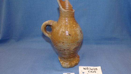
    Excavation for the Hull Heat Network has exposed medieval remains dating back around 700 years, forcing design teams to coordinate trench routes and depths with on-site archaeologists. Trial pits and open-cut sections for district heating pipework in the city centre have revealed structural remains and artefacts that require recording and, in some cases, redesign of alignments. Contractors face programme and access constraints as archaeological works run in parallel with installing buried hot-water mains and associated chambers in narrow urban streets.

    Technical Brief

    • Any human burials encountered would invoke Ministry of Justice licensing and strict exhumation handling protocols.
    • Work sequencing must allow archaeologists safe access in confined trenches, avoiding plant–personnel interface conflicts.
    • Temporary works and shoring designs need flexibility for local widening or deepening where significant structures emerge.
    • Risk assessments require live updating to reflect changing ground conditions as masonry, voids or soft backfill are exposed.
    • Permit-to-dig and service-location procedures become more complex where historic foundations obscure utility survey signatures.
    • Discovery of heritage assets can extend occupation of traffic-management setups, increasing exposure to roadworker safety risks.

    Our Take

    Hull is relatively under-represented in our 839 Infrastructure stories, so the Hull Heat Network project stands out as one of the few major urban utility digs in the region where archaeological risk is clearly materialising on site.

    Discoveries dating back 700 years typically trigger closer coordination between project teams and heritage bodies; in other UK urban utility schemes this has led to revised method statements and tighter exclusion zones, which can affect programme and trench sequencing.

    Because New Civil Engineer is also pushing digital handover themes in its recent webinar coverage, the Hull Heat Network finds itself in a cohort of projects where capturing archaeological and ground-condition data in common data environments is becoming as important as recording the installed heat network assets themselves.

    Geotechnical Software for Modern Teams

    Centralise site data, logs, and lab results with GEODB-io, CMRR-io, and HYDROGEO-io.

    No credit card required.

    • Save and export unlimited calculations
    • Advanced data visualisation
    • Generate professional PDF reports
    • Cloud storage for all your projects

    Prepared by collating external sources, AI-assisted tools, and Geomechanics.io’s proprietary mining database, then reviewed for technical accuracy & edited by our geotechnical team.

    Related Articles

    Strabag’s Pfaffensteig Tunnel contract: design and delivery notes for rail engineers
    Infrastructure
    in 7 months

    Strabag’s Pfaffensteig Tunnel contract: design and delivery notes for rail engineers

    Strabag and Group company Züblin have secured the design-and-build structural works for the ABS Gäubahn Nord/Pfaffensteig Tunnel in south-west Germany, centred on an 11km twin-bore rail tunnel linking Stuttgart Airport station directly to the Gäubahn line towards Switzerland. About 9.8km will be driven by two TBMs, with conventional tunnelling for the A8 motorway undercrossing and airport connection, plus a 240m cut-and-cover section, retaining structures, railway underpasses and a grade-separated crossing. A 3km surface section will be upgraded and partially realigned for 200km/h operation, delivered under an integrated project delivery model with Ed. Züblin, Wayss & Freytag and Strabag AG sharing tunnelling, structural and earthworks packages.

    National Grid TBM under the Thames: tunnelling design and risk notes for engineers
    Infrastructure
    in 7 months

    National Grid TBM under the Thames: tunnelling design and risk notes for engineers

    A 271.5‑tonne Herrenknecht Mixshield TBM, Caroline, has started driving a 2.2km electricity cable tunnel with a 4m internal diameter beneath the River Thames in Essex for National Grid’s Grain to Tilbury project, delivered by the Ferrovial BEMO joint venture. The drive will pass through variable Thames estuary ground conditions between 35m‑deep launch and reception shafts of 15m and 12m diameter, with tunnelling continuing into 2026 and overall scheme completion targeted for 2029. The new tunnel will replace the 1969 Thames Cable Tunnel and carry new high‑voltage circuits between Grain and Tilbury substations.

    Panama Canal Mixshield undercrossing: design and tunnelling lessons for engineers
    Infrastructure
    in 7 months

    Panama Canal Mixshield undercrossing: design and tunnelling lessons for engineers

    A 13.46m diameter Herrenknecht Mixshield TBM has broken through into the future Balboa station on Panama Metro Line 3 after completing the first-ever TBM undercrossing of the Panama Canal at depths exceeding 60m below sea level. The 5,600kW, 26,616kNm machine, fitted with an accessible cutterhead and more than 4,500 sensors linked via the Herrenknecht.Connected platform, has achieved peak advance of 150 segment rings (about 300m) per month through mixed sandstone, tuff, breccias and basalt. Around 1.5km of the 4.5km twin-track tunnel remains to final breakthrough.

    Related Industries & Products

    Construction

    Quality control software for construction companies with material testing, batch tracking, and compliance management.

    Mining

    Geotechnical software solutions for mining operations including CMRR analysis, hydrogeological testing, and data management.

    CMRR-io

    Streamline coal mine roof stability assessments with our cloud-based CMRR software featuring automated calculations, multi-scenario analysis, and collaborative workflows.

    HYDROGEO-io

    Comprehensive hydrogeological testing platform for managing, analysing, and reporting on packer tests, lugeon values, and hydraulic conductivity assessments.

    GEODB-io

    Centralised geotechnical data management solution for storing, accessing, and analysing all your site investigation and material testing data.

    AllGeotechnicalInfrastructureHazardsEnvironmental