Geomechanics.io

  • Free Tools
Sign UpLog In

    Geomechanics.io

    Geomechanics, Streamlined.

    © 2026 Geomechanics.io. All rights reserved.

    Geomechanics.io

    CMRR-ioGEODB-ioHYDROGEO-ioQCDB-ioFree Tools & CalculatorsBlogLatest Industry News

    Industries

    MiningConstructionTunnelling

    Company

    Terms of UsePrivacy PolicyLinkedIn
    Projects

    Europe’s deepest offshore breakwater: geotechnical design lessons for engineers

    March 24, 2026|

    Reviewed by Joe Ashwell

    Europe’s deepest offshore breakwater: geotechnical design lessons for engineers

    First reported on New Civil Engineer

    30 Second Briefing

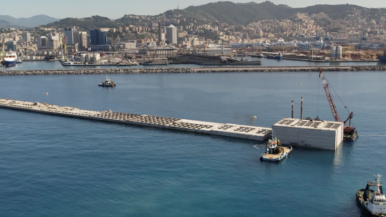
    Construction of a 6km offshore breakwater with Europe’s deepest foundations is pushing marine geotechnical limits, with caissons and foundation elements installed in exceptionally deep water using heavy-lift vessels and precision positioning systems. Complex offsite fabrication of large concrete units, likely in a dedicated casting yard with slipform or match-cast techniques, is being coordinated with narrow marine weather windows and high-capacity barges to maintain programme. For designers and contractors, the project stresses accurate seabed characterisation, robust scour protection detailing and tight control of tolerances during submerged placement.

    Technical Brief

    • Geotechnical investigations used closely spaced offshore boreholes and CPTs to characterise highly variable seabed stratigraphy.
    • Designers adopted staged construction sequences to limit differential settlement between adjacent caissons along the alignment.
    • Rock armour gradings and underlayer specifications were tailored to deep-water wave loading and long-period swell.
    • Survey control relies on integrated GNSS, gyro and subsea acoustic positioning to maintain millimetre-level placement tolerances.
    • Concrete mix designs were optimised for low heat of hydration and durability under aggressive marine exposure classes.
    • Fabrication logistics included dedicated storage berths and rotation plans to prevent casting yard bottlenecks as units cured.
    • For future large marine energy or port schemes, comparable depth-driven constraints will likely dictate similar offshore-focused geotechnical workflows.

    Geotechnical Software for Modern Teams

    Centralise site data, logs, and lab results with GEODB-io, CMRR-io, and HYDROGEO-io.

    No credit card required.

    • Save and export unlimited calculations
    • Advanced data visualisation
    • Generate professional PDF reports
    • Cloud storage for all your projects

    Prepared by collating external sources, AI-assisted tools, and Geomechanics.io’s proprietary mining database, then reviewed for technical accuracy & edited by our geotechnical team.

    Related Articles

    Mitchells Causeway NSW road fix: geotechnical design notes for ground engineers
    Geotechnical
    4 days ago

    Mitchells Causeway NSW road fix: geotechnical design notes for ground engineers

    Two engineering consortia have been shortlisted by the New South Wales Government to design and deliver a fix for Mitchells Causeway on the Great Western Highway at Victoria Pass, closed since March after substantial cracking and ground movement were detected. The move follows an industry briefing and on-site inspection involving 20 Australian and international firms, signalling complex geotechnical and structural stabilisation requirements on this steep Blue Mountains section. Outcomes will directly affect detour durations, heavy vehicle access and long-term slope and pavement performance on this key freight and commuter corridor.

    Mexico City’s sinking crisis mapped by NISAR: geotechnical design notes for engineers
    Geotechnical
    10 days ago

    Mexico City’s sinking crisis mapped by NISAR: geotechnical design notes for engineers

    Mexico City’s subsidence has been mapped in new detail by the NASA–ISRO NISAR L-band radar mission, revealing metropolitan zones sinking by more than 50cm per year over clay-rich former lakebed deposits. Interferometric SAR time-series show differential settlement across key infrastructure corridors, with some districts exhibiting cumulative subsidence of several metres over recent decades, far exceeding typical building serviceability limits. The data set offers geotechnical engineers block-scale deformation rates to refine foundation design, tunnel and metro monitoring, and groundwater extraction management.

    Brownfield success: integrated ground data workflows for project teams
    Geotechnical
    12 days ago

    Brownfield success: integrated ground data workflows for project teams

    Brownfield infrastructure projects are seeing geotechnical and environmental teams urged to integrate ground investigation, contamination data and 3D ground models from the outset, rather than running parallel site characterisation workflows. The piece stresses unified digital datasets combining borehole logs, in situ test results and contaminant plumes to refine ground risk registers, optimise foundation and earthworks design, and avoid late-stage remediation surprises. Case experience shows that early joint modelling of variable made ground, buried obstructions and legacy industrial pollution can materially cut unforeseen ground conditions claims and programme delays.

    Related Industries & Products

    Construction

    Quality control software for construction companies with material testing, batch tracking, and compliance management.

    Mining

    Geotechnical software solutions for mining operations including CMRR analysis, hydrogeological testing, and data management.

    QCDB-io

    Comprehensive quality control database for manufacturing, tunnelling, and civil construction with UCS testing, PSD analysis, and grout mix design management.

    AllGeotechnicalInfrastructureHazardsEnvironmental