£100M A47 upgrade: capacity, safety and access design notes for project teams
Reviewed by Joe Ashwell
First reported on New Civil Engineer
30 Second Briefing
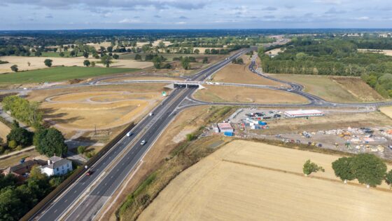
A £100M upgrade of the A47 in Norfolk is entering its final construction phase, with contractors targeting completion of new dual carriageway sections and junction improvements designed to increase capacity on this key east–west corridor. Works include realigned approaches, additional lanes and upgraded signalised junctions to reduce queuing and collision risk at existing bottlenecks. The scheme is also providing new access roads and serviced plots to unlock adjacent development land for local industrial and commercial use.
Technical Brief
- Final construction phase implies live-traffic working with temporary alignments and reduced cross-sections, elevating workzone risk.
- Staged tie-ins to existing A47 likely require night possessions and strict temporary signal phasing to manage conflicts.
- Proximity to development plots introduces additional access points, demanding careful control of turning movements and sightlines.
- Norfolk’s relatively flat, low-lying terrain increases emphasis on surface water management to prevent hydroplaning and spray.
- Interface with local business traffic requires segregated access roads to remove slow-moving HGVs from high-speed flows.
- Construction traffic management must separate heavy plant haul routes from public carriageways to minimise collision exposure.
- Lessons on integrating safety-led junction upgrades with land-release objectives will inform similar UK trunk road schemes.
Our Take
New Civil Engineer’s recent webinar on BIM, CDEs and asset data handover suggests that, as this A47 project nears completion, the client and contractors will be under pressure to ensure digital asset information is clean and complete at close-out to avoid the ‘data handover gap’ now being highlighted across UK infrastructure schemes.
Prepared by collating external sources, AI-assisted tools, and Geomechanics.io’s proprietary mining database, then reviewed for technical accuracy & edited by our geotechnical team.


